

El Niño intensifies Puerto Rico's record drought and water crisis as water rationing begins
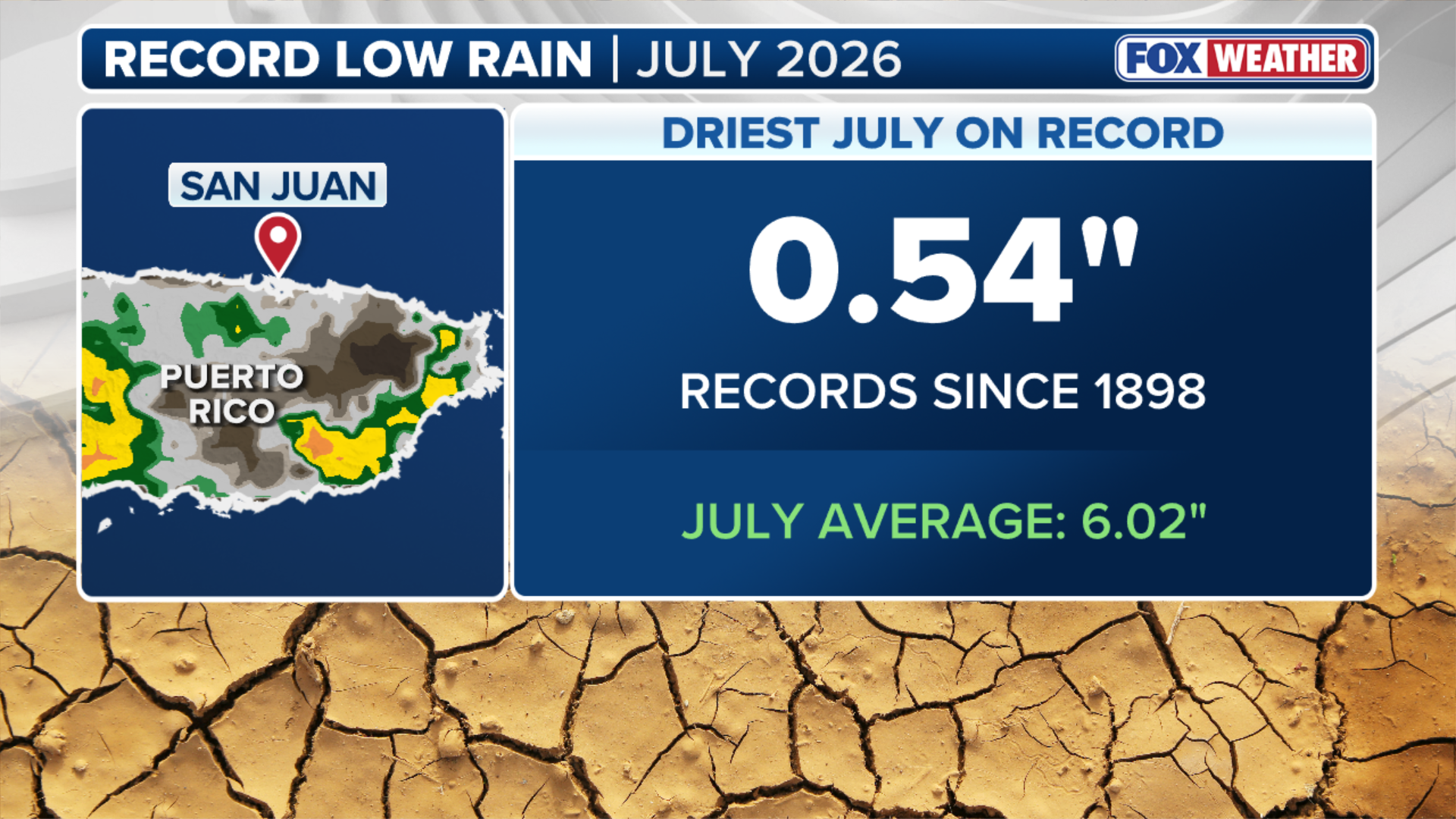
This follows San Juan’s driest July since record-keeping began in 1898, with just a half-inch of rain recorded this past month.
Looming 'Super' El Niño is limiting tropical activity across the Atlantic Basin
🌀 EXCLUSIVE ANALYSIS: FOX Weather Hurricane Specialist Bryan Norcross shares the latest updates from NOAA on the developing El Niño, the quiet start to the season so far, and the number of named storms that could form.
SAN JUAN, Puerto Rico — Water rationing officially began across parts of Puerto Rico Friday as the U.S. commonwealth grapples with significant drought and water shortages. Forecasters say a strong El Niño climate pattern is now intensifying drought conditions, with little relief expected as El Niño could reach historic strength later this year.
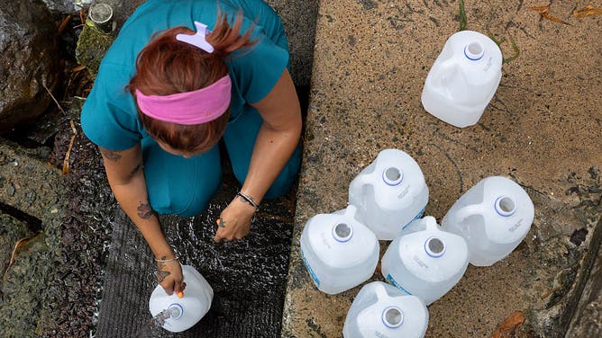
![]() Image 1 of 6
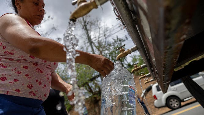
Image 1 of 6A resident fills water containers from a natural spring during a mandatory water rationing imposed amid a severe drought in Trujillo Alto, Puerto Rico, on August 6, 2026. About 180,000 customers across Puerto Ricos's capital San Juan and surrounding municipalities are experiencing water shortages worsened by underinvestment and poor physical maintenance that have left the island's aqueduct and sewer system vulnerable to leaks and failures, according to community leaders and local officials in the US territory. ((Photo by Ricardo ARDUENGO / AFP via Getty Images))
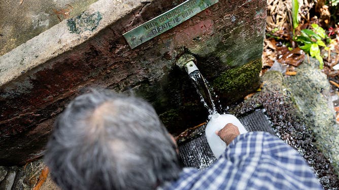
![]() Image 2 of 6
Image 2 of 6A resident fills a water container from a natural spring beneath a sign reading "God Bless This Fountain of Life" during a mandatory water rationing imposed amid a severe drought in Trujillo Alto, Puerto Rico, on August 6, 2026. About 180,000 customers across Puerto Ricos's capital San Juan and surrounding municipalities are experiencing water shortages worsened by underinvestment and poor physical maintenance that have left the island's aqueduct and sewer system vulnerable to leaks and failures, according to community leaders and local officials in the US territory. (Photo by Ricardo ARDUENGO / AFP via Getty Images) ((Photo by Ricardo ARDUENGO / AFP via Getty Images))
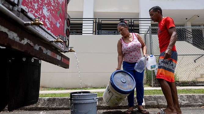
![]() Image 3 of 6
Image 3 of 6Residents collect water from a tanker truck at a distribution point during a government imposed water rationing amid a severe drought in San Juan, Puerto Rico, on August 6, 2026. About 180,000 customers across Puerto Ricos's capital San Juan and surrounding municipalities are experiencing water shortages worsened by underinvestment and poor physical maintenance that have left the island's aqueduct and sewer system vulnerable to leaks and failures, according to community leaders and local officials in the US territory. (Photo by Ricardo ARDUENGO / AFP via Getty Images) ((Photo by Ricardo ARDUENGO / AFP via Getty Images))
![]() Image 4 of 6
Image 4 of 6A resident collects water from a tanker truck at a distribution point during a government imposed water rationing amid a severe drought in San Juan, Puerto Rico, on August 6, 2026. About 180,000 customers across Puerto Ricos's capital San Juan and surrounding municipalities are experiencing water shortages worsened by underinvestment and poor physical maintenance that have left the island's aqueduct and sewer system vulnerable to leaks and failures, according to community leaders and local officials in the US territory. (Photo by Ricardo ARDUENGO / AFP via Getty Images) ((Photo by Ricardo ARDUENGO / AFP via Getty Images))
![]() Image 5 of 6
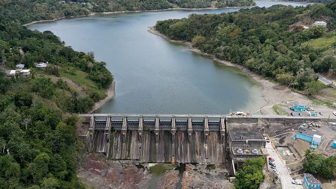
Image 5 of 6This aerial view shows the Carraizo Dam, one of the main water reservoirs supplying the San Juan metropolitan area, during a government imposed water rationing amid a severe drought in Trujillo Alto, Puerto Rico, on August 6, 2026. About 180,000 customers across Puerto Ricos's capital San Juan and surrounding municipalities are experiencing water shortages worsened by underinvestment and poor physical maintenance that have left the island's aqueduct and sewer system vulnerable to leaks and failures, according to community leaders and local officials in the US territory. (Photo by Ricardo ARDUENGO / AFP via Getty Images) ((Photo by Ricardo ARDUENGO / AFP via Getty Images))
![]() Image 6 of 6
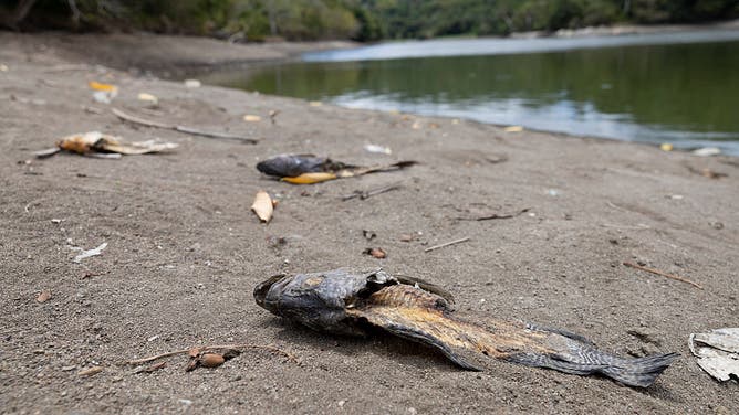
Image 6 of 6Dead fish lie along the exposed shoreline of Carraizo Reservoir, one of the main water reservoirs supplying the San Juan metropolitan area, during a government imposed water rationing amid a severe drought in Trujillo Alto, Puerto Rico, on August 6, 2026. About 180,000 customers across Puerto Ricos's capital San Juan and surrounding municipalities are experiencing water shortages worsened by underinvestment and poor physical maintenance that have left the island's aqueduct and sewer system vulnerable to leaks and failures, according to community leaders and local officials in the US territory. (Photo by Ricardo ARDUENGO / AFP via Getty Images) ((Photo by Ricardo ARDUENGO / AFP via Getty Images))
Seven municipalities in northeastern Puerto Rico supplied by the Carraízo Reservoir and Sergio Cuevas filtration plant, including San Juan, will have water service interrupted for up to two days at a time, according to Puerto Rico’s Aqueduct and Sewer Authority.
This follows San Juan’s driest July since record-keeping began in 1898, with just a half-inch of rain recorded this past month.
(FOX Weather)
The drought began developing in late April as water levels for the Carraizo Reservoir, which services the San Juan metropolitan area, began to nosedive — now more than 11 feet below full pool.
Drought conditions had already caused water service disruptions in the nearby municipalities of Río Grande and Canóvanas in July.
Puerto Rico Governor Jennifer Gonzalez Colon declared a State of Emergency on July 31 due to a significant decrease in water levels at main reservoirs caused by a lack of rainfall.
The governor ordered island agencies to prioritize areas with the biggest water needs.
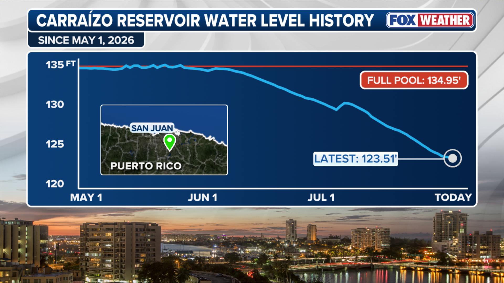
(FOX Weather)
This comes amid ongoing challenges with Puerto Rico’s water and electrical infrastructure.
In her executive order, Gov. Gonzalez Colon blamed El Niño for the ongoing drought across the Caribbean, and said the problem was being compounded by increased forest fires, hotter temperatures and plumes of Saharan dust being blown across the Atlantic.
While El Niño's hostile winds have limited tropical development in the Atlantic this year, those same winds are exacerbating the drought in the Caribbean.
El Niño is one of three phases of a climate cycle called the El Niño-Southern Oscillation (ENSO). It describes natural temperature changes in the central Pacific Ocean that alter atmospheric circulation and can greatly influence global weather.
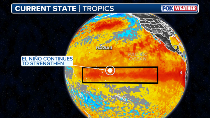
This graphic shows the El Niño zone.
(FOX Weather)
El Niño describes warmer than average water across the equatorial Pacific, while La Niña describes colder than average water conditions, and ENSO neutral refers to a state where temperatures are close to average.
During El Niño, above-average water temperatures in the central and eastern Pacific Ocean alter the position and strength of the subtropical jet stream. It's typically more robust and extends well into the Caribbean and Atlantic Ocean. The jet stream is a belt of very fast winds high in the atmosphere.
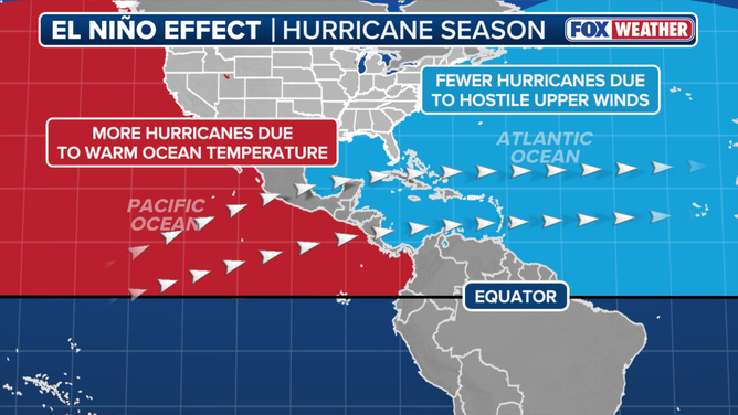
El Niño impact on hurricane season.
(FOX Weather / FOX Weather)
It's these strong westerly winds that hinder tropical development in the Atlantic during an El Niño. Calm conditions are generally more conducive to hurricane formation.
Those same winds tear apart cloudtops and limit thunderstorm development in the Caribbean, intensifying the ongoing drought.
NOAA officially declared El Niño conditions were present in June.
The FOX Forecast Center added that El Niño also produces large-scale sinking air across the Caribbean, which also limits storm development.
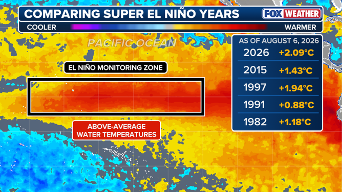
Super El Niño comparison
(FOX Weather)
When water temperatures in the El Niño zone reach at least 2 degrees Celsius above average for at least three consecutive months, it is considered a Super El Niño.
According to NOAA, some computer forecast models suggest this El Niño could be the strongest event since record keeping began in 1950. In its July update, NOAA said El Niño could reach historically strong conditions between October and December, with a 97% chance of lasting through next spring.
However, the agency cautioned that a record-breaking El Niño event could produce atmospheric impacts never before seen.
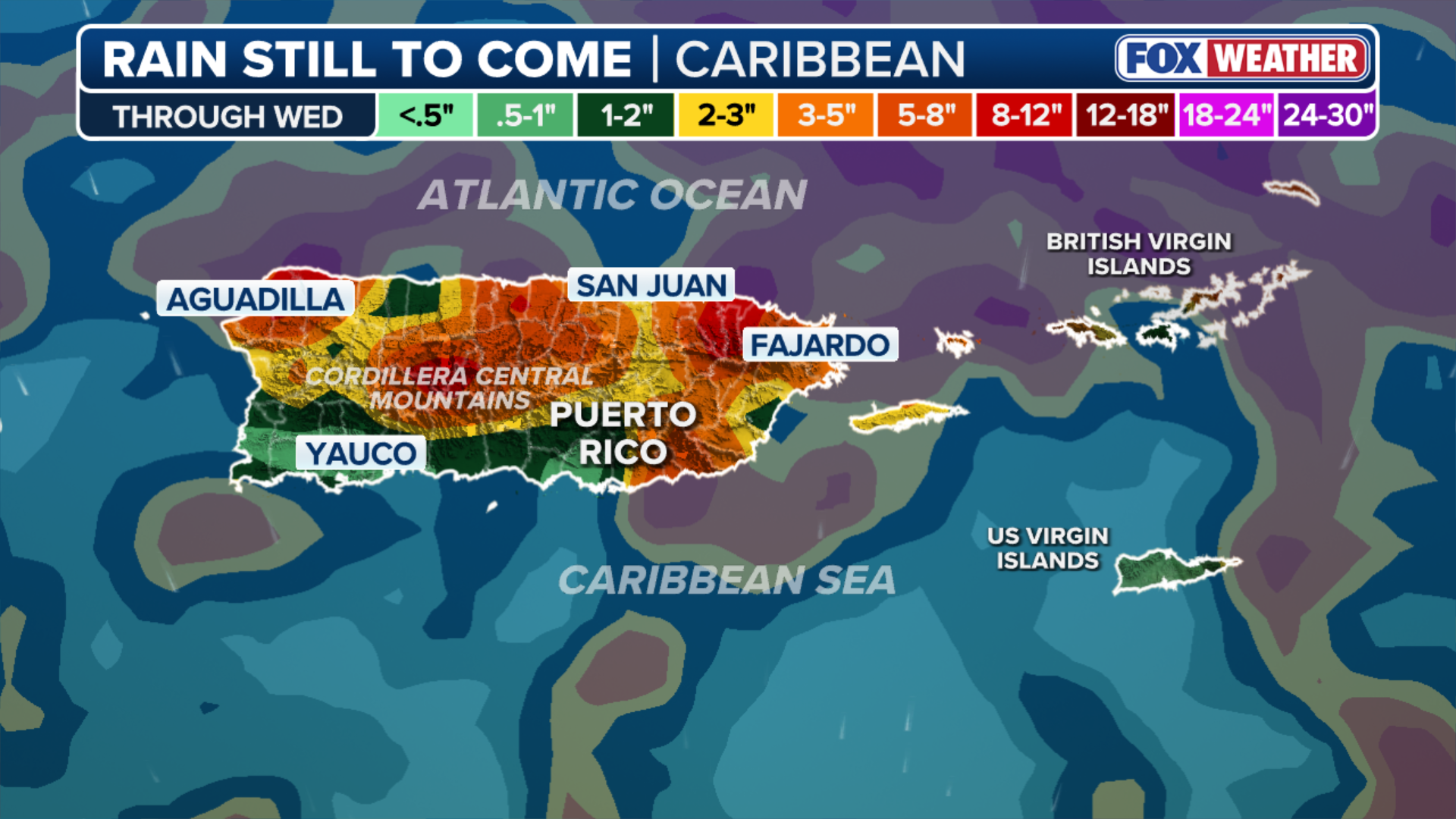
(FOX Weather)
"A strong event could have different impacts than those traditionally observed as opposed to similar impacts with greater intensity," NOAA said.
Meanwhile, Puerto Rico is expected to get some relief through next Wednesday, with up to an inch of rain along the island’s northern coast and pockets of 3 to 5 inches in the central mountains.