El Nino essentially slam dunk to persist through winter
Temperatures have kept climbing well beyond the El Niño threshold – considered when waters warm more than 0.5 degrees Celsius above average – and now NOAA says its latest measurements recorded the anomaly at 1 degree Celsius above average.
What is an El Nino weather pattern
El Ninos are known to produce extreme weather around the globe. The world entered an El Nino in June 2023, and events are known to produce both good and bad impacts.
El Niño is here and shows no signs of stopping for the next several months, according to an updated forecast from NOAA’s Climate Prediction Center.
Ocean temperatures in the tropical Pacific have been warming for months on the heels of a stubborn three-year La Niña period and crossed into El Niño territory in June.
Temperatures have kept climbing well beyond the El Niño threshold – considered when waters warm more than 0.5 degrees Celsius above average – and now NOAA says its latest measurements recorded the anomaly at 1 degree Celsius above average.
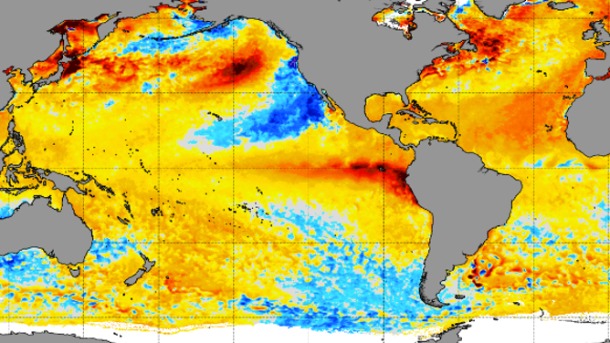
Current sea-surface temperature chart in the Pacific Ocean showing above-average temperatures in the equatorial Pacific.
(NOAA)
In addition, forecasts indicate temperatures will continue warming into moderate-to-strong intensity, with a 20% chance that El Niño reaches "historically strong" levels this winter.
Some experts have dubbed El Niño to be the world’s ultimate "master weather-maker" as its influences impact everything from animal migrations to the amount of billion-dollar disasters reported around the globe.
The new forecast now gives a greater than 90% chance of El Niño holding through the winter and into 2024.
EL NIÑO DELIVERS ON EXPECTATIONS WORLD IS HEADING TOWARDS PERIOD OF ALL-TIME RECORD HEAT
Warm ocean temperatures in Atlantic may counteract El Nino's tropic-suppressing powers
According to NOAA, an El Niño event typically lasts 9 to 12 months, while La Niñas can endure for years
If the current El Niño follows precedent, this year’s summer, hurricane season, winter and the spring 2024 severe weather season will all be impacted by the climate pattern’s sphere of influence.
"During El Niño, unusually warm sea-surface temperatures in the central/eastern tropical Pacific lead to increased evaporation and cooling of the ocean. At the same time, the increased cloudiness blocks more sunlight from entering the ocean. When water vapor condenses and forms clouds, heat is released into the atmosphere," NOAA climate experts wrote in a 2022 blog.
Typically, El Niño summers will suppress tropical activity in the Atlantic Ocean due to increased wind shear. However, this season may end up an exception due to much warmer-than-average water temperatures in the Atlantic.

Warm water temperatures are common across the Atlantic basin
(FOX Weather)
Hurricane experts at Colorado State University have increased the anticipated amount tropical cyclones they expect to form in the Atlantic Basin during the 2023 season and warn the year might finish with above-average activity.
The updated annual outlook now calls for 18 named storms, nine hurricanes and four that will reach major hurricane status with winds of at least 115 mph.
"While we continue to anticipate a robust El Niño for the peak of the Atlantic hurricane season, most of the tropical and subtropical Atlantic now has record-warm sea-surface temperatures. El Niño increases vertical wind shear in the Caribbean and tropical Atlantic, but the extreme anomalous warmth in the tropical and subtropical Atlantic may counteract some of the typical El Niño-driven increase in vertical wind shear," authors of the updated CSU Atlantic hurricane season outlook stated.
HOW EL NIÑO, ‘FREAKISH’ WARM OCEANS FACTOR INTO HURRICANE SEASON
Previous El Niño impacts on the US
The last El Niño event to impact the country was during 2018-19, and it helped produce over a year of warm temperatures and plentiful precipitation over the country.
The event was considered weak, with water temperatures in critical parts of the Pacific only reaching between 0.5 and 1 degree Celsius above average.
During the El Niño-impacted years, climatologists noted departures of overnight temperatures were greater compared to afternoon temperature anomalies.
Warm overnight lows prevent people and buildings from recovering from the daytime heat, leading to more extensive and dangerous heat waves.
Tropical cyclone experts believe the climate pattern did not play a significant role in overall activity during the 2018 or 2019 hurricane seasons; in fact, both years recorded above-average activity and produced storms such as Florence, Michael and Dorian.