'Strong' El Nino confidence increases through winter, meteorologists say
An El Nino is a climate pattern in which warming waters of the central and eastern Pacific Ocean have significant impacts on global weather.

Meteorologists predict 95% chance of El Nino with greater confidence in a 'strong' El Nino event
Chances of an El Nino have increased from 90% to 95% for this year, according to meteorologists at NOAA. August 10, 2023.
NOAA announced on Thursday that the chances of an El Niño event this year have increased from 90% to greater than 95% certainty, with greater confidence in a "strong" El Niño event leading into this winter.
"Given recent developments, forecasters are more confident in a 'strong' El Niño event, with roughly 2 in 3 odds of an event reaching or exceeding 1.5°C for the November-January seasonal average in Niño-3.4," NOAA said.
An El Niño is a climate pattern in which warming waters of the central and eastern Pacific Ocean have significant impacts on global weather. For this to occur, the sea surface temperature anomalies in an El Nino rise above .5 degrees Celsius.
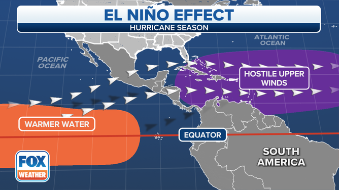
El Nino impacts on the western Atlantic basin.
(FOX Weather)
Stronger El Niño events, including that which NOAA is forecasting, can occur when the sea surface temperature anomalies rise to one degree Celsius and 1.5 degrees Celsius. The latter produces an event similar to some of the strongest El Niños in history, according to FSU meteorology professor Michael Diamond.
EL NINO ESSENTIALLY A SLAM DUNK TO PERSIST THROUGH WINTER
Diamond noted that, in addition to the amount the sea surface temperature anomalies increase, the location of those anomalies should also be taken into account.
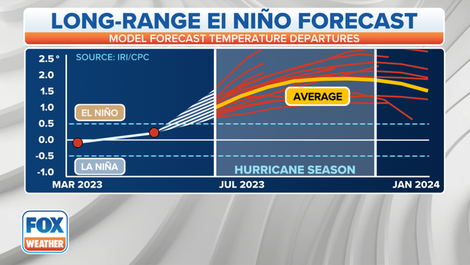
El Nino model predictions for 2023
(FOX Weather)
"Some of these more Eastern Pacific El Niños tend to be the ones that have these ultimately strongest anomalies and strongest climate impacts," he said. "So far this year, this looks like a very Eastern-driven El Niño event."
WHAT ARE THE EL NINO AND LA NINA CLIMATE PATTERNS?
The El Niños event is expected to continue through the Northern Hemisphere winter, according to NOAA.