Potential derecho spawning tornadoes, hurricane-force winds threatens several states across Plains, Midwest
Intense thunderstorms are expected to develop over western South Dakota in the afternoon and move east through the evening and overnight hours. "The destructive winds today could very well do damage just like tornadoes do," FOX Weather Meteorologist Stephen Morgan warned.

Ingredients for powerful derecho coming together in Plains, Midwest overnight
Meteorologist Ian Oliver outlines the forecast for a derecho packing tornadoes and powerful winds in the Plains and Midwest overnight.
ABERDEEN, S.D. – The northern Plains, including the Dakotas, Iowa and Minnesota, are in the bull's-eye of a renewed severe weather threat Monday that is expected to bring violent, damaging wind gusts.
According to NOAA's Storm Prediction Center, a derecho is expected to blast across portions of the northern Plains on Monday, with the potential for several wind gusts of over 75 mph. Tornadoes and large hail are also possible across this region.

A tornado near Gregory, South Dakota on July 28, 2025.
(Brandon Copic / FOX Weather)
A derecho is a cluster of thunderstorms that produces destructive wind gusts for hundreds of miles.

(FOX Weather)
For meteorologists to classify a windstorm as a derecho – from the Spanish word for "straight" – the swath of straight-line wind damage it causes must contain multiple wind reports of at least 75 mph that are associated with the same cluster of thunderstorms.
Intense thunderstorms are expected to develop over western South Dakota in the afternoon and move east through the evening and overnight hours.
Storms have already spawned tornado reports across South Dakota, including in Gregory, where FOX Weather Storm Chaser Brandon Copic was on the ground tracking a large twister.
The storms are being driven by a cold front that is charging south and eastward.
More than one million people in eastern South Dakota, a portion of southwestern Minnesota and part of northern Iowa are under a Level 4 out of 5 risk of severe thunderstorms, according to NOAA's Storm Prediction Center.
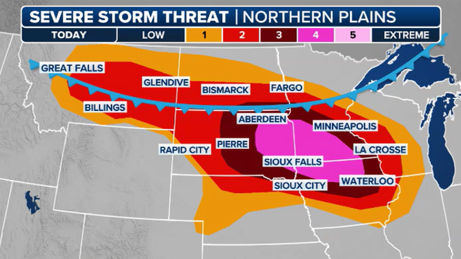
This graphic shows the severe weather threat for Monday, July 28, 2025.
(FOX Weather)
This area includes the cities of Aberdeen, Watertown and Brookings in South Dakota, as well as Mankato, Minnesota and Mason City, Iowa.
Minneapolis and St. Paul, Minnesota are under a Level 3 out of 5 threat.
Additional scattered severe thunderstorms could also produce damaging winds and hail farther west across portions of Montana.

Watch: Massive tornado tears across South Dakota landscape
A dramatic video shared by exclusive FOX Weather Storm Tracker Brandon Copic shows a massive tornado tearing across the landscape in Watertown, South Dakota, on July 27, 2025.
FOX Weather Meteorologist Stephen Morgan warned people on Monday not to underestimate the power of straight-line wind gusts.
"The destructive winds today could very well do damage just like tornadoes do," Morgan said. "A lot of times these derechoes, if that's what we end up getting, what these windstorms can bring, it's a much wider path of damage."
This comes just a day after a prior round of severe weather in South Dakota. Copic intercepted a tornado spinning across the area in Watertown that destroyed at least one building.
WATCH: MASSIVE TORNADO SPOTTED TEARING THROUGH SOUTH DAKOTA
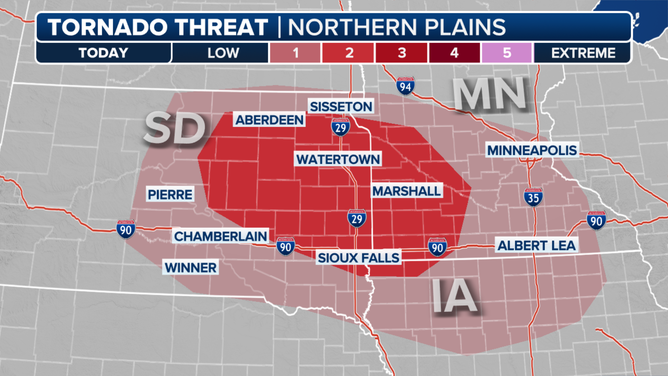
This graphic shows the tornado threat for Monday, July 28, 2025.
According to the FOX Forecast Center, tornadoes are also increasingly likely, especially along the leading edge of any line of severe storms.
Leftover thunderstorms are expected to reach parts of Wisconsin and Illinois on Tuesday morning.