Flash flooding turns deadly as severe thunderstorms pummel Texas, Oklahoma
At least two drivers were killed in Oklahoma following flash flooding on Tuesday and Wednesday.

Watch: Roads flooded in Pottawatomie County, Oklahoma
A video recorded in Pottawatomie County, Oklahoma, shows strees that were flooded after torrential rain fell across the region on April 30, 2025.
OKLAHOMA CITY – More rounds of torrential rain and severe weather plowed across the southern Plains on Wednesday, causing deadly flooding and numerous reports of damage.
There have been at least two deaths associated with flooding in Oklahoma.
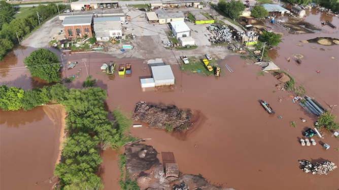
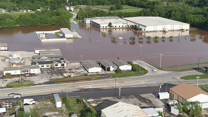
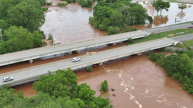
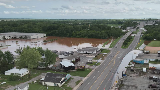
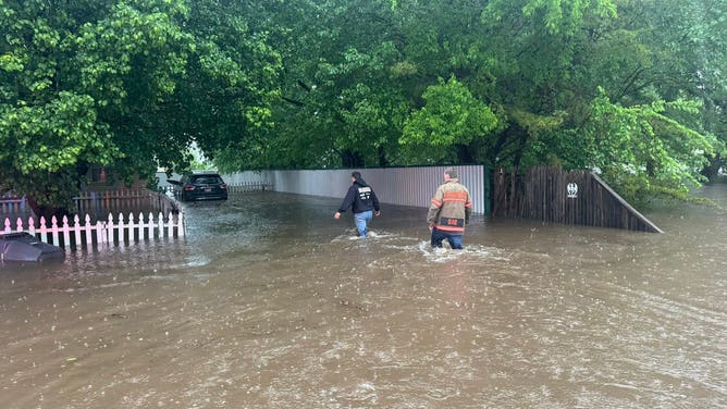
![This drone image shows flooding in Purcell, Oklahoma, on Wednesday, April 30, 2025.]() Image 1 of 10
Image 1 of 10This drone image shows flooding in Purcell, Oklahoma, on Wednesday, April 30, 2025. (Purcell Police Department/Facebook)
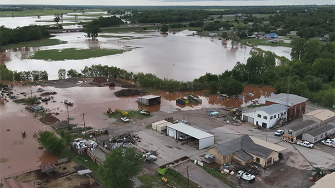
![This drone image shows flooding in Purcell, Oklahoma, on Wednesday, April 30, 2025.]() Image 2 of 10
Image 2 of 10This drone image shows flooding in Purcell, Oklahoma, on Wednesday, April 30, 2025. (Purcell Police Department/Facebook)
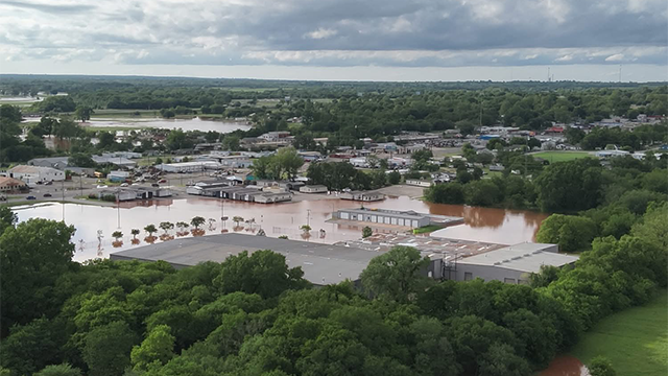
![This drone image shows flooding in Purcell, Oklahoma, on Wednesday, April 30, 2025.]() Image 3 of 10
Image 3 of 10This drone image shows flooding in Purcell, Oklahoma, on Wednesday, April 30, 2025. (Purcell Police Department/Facebook)
![This drone image shows flooding in Purcell, Oklahoma, on Wednesday, April 30, 2025.]() Image 4 of 10
Image 4 of 10This drone image shows flooding in Purcell, Oklahoma, on Wednesday, April 30, 2025. (Purcell Police Department/Facebook)
![This drone image shows flooding in Purcell, Oklahoma, on Wednesday, April 30, 2025.]() Image 5 of 10
Image 5 of 10This drone image shows flooding in Purcell, Oklahoma, on Wednesday, April 30, 2025. (Purcell Police Department/Facebook)
![This drone image shows flooding in Purcell, Oklahoma, on Wednesday, April 30, 2025.]() Image 6 of 10
Image 6 of 10This drone image shows flooding in Purcell, Oklahoma, on Wednesday, April 30, 2025. (Purcell Police Department/Facebook)
![This drone image shows flooding in Purcell, Oklahoma, on Wednesday, April 30, 2025.]() Image 7 of 10
Image 7 of 10This drone image shows flooding in Purcell, Oklahoma, on Wednesday, April 30, 2025. (Purcell Police Department/Facebook)
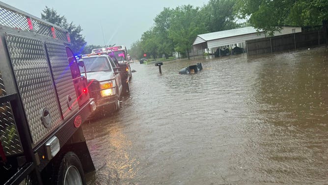
![The Lexington Fire Department is working to evacuate those from flooded homes as torrential rain hits Oklahoma on Wednesday.]() Image 8 of 10
Image 8 of 10The Lexington Fire Department is working to evacuate those from flooded homes as torrential rain hits Oklahoma on Wednesday. (Lexington Fire Dept.)
![The Lexington Fire Department is working to evacuate those from flooded homes as torrential rain hits Oklahoma on Wednesday.]() Image 9 of 10
Image 9 of 10The Lexington Fire Department is working to evacuate those from flooded homes as torrential rain hits Oklahoma on Wednesday. (Lexington Fire Dept.)
![The Lexington Fire Department is working to evacuate those from flooded homes as torrential rain hits Oklahoma on Wednesday.]() Image 10 of 10
Image 10 of 10The Lexington Fire Department is working to evacuate those from flooded homes as torrential rain hits Oklahoma on Wednesday. (Lexington Fire Dept.)

Officials in Pottawatomie County, outside of Oklahoma City, reported that a driver was swept away by floodwaters, and a responding deputy required assistance due to the strong current.
Another death was reported in nearby Lincoln County.

Watch: Time-lapse video shows severe weather blasting through Pittsburgh
A time-lapse video showed severe weather pushing through Pittsburgh as powerful storms moved through the region on Tuesday, April 29, 2025.
The storm threat on Wednesday came after at least three people were killed and hundreds of thousands of people were left without power in Pennsylvania after a serial derecho tore across communities from the Plains to the Midwest and into the Northeast on Tuesday.
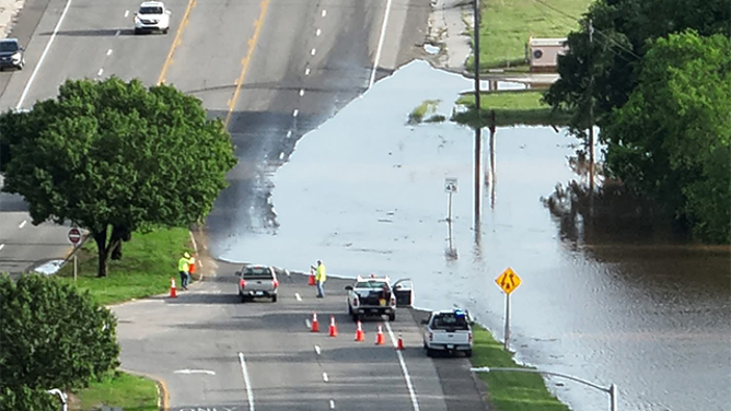
Flooding forced officials to close a section of Interstate 35 in Oklahoma City because of water on the roadway, impacting travel in the area.
Officials in Pottawatomie County alone reported dozens of road closures, and damage assessments would take days to complete.
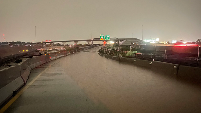
The heavy rainfall caused troopers to shut down northbound Interstate 35 at Interstate 44 in the Oklahoma City metro due to significant flooding.
(@OHPDPS/X / FOX Weather)
Farther south in Texas, it was hailstones and winds that were problematic, with reported wind gusts approaching 100 mph.
A video from Mabelle, Texas, captured the moments a driver crawled out of a semi-truck that was blown over during the severe weather.
No major injuries were reported, but about 100,000 power outages were reported across the southern Plains.

Fierce winds topple tractor trailer in Texas
A tractor trailer toppled amid raging wind and rain Tuesday night near Mabelle, Texas.This dramatic video was captured by KJTL/KDFX storm chaser Kyle G. around 7:00 p.m. local time. Baylor County, Texas was one of the hardest hit areas by Tuesday's deadly severe weather.
Rainfall not over yet for region
As long as frontal boundaries find their way into the southern Plains and the lower Mississippi Valley, the chance of scattered showers and thunderstorms will continue to persist into the early weekend.
Computer forecast models indicate an additional 1-4 inches of precipitation could fall over the Red River Valley through the early weekend.
Most storms are expected to remain below severe weather criteria, but a few could produce hail, damaging winds and isolated tornadoes.

(FOX Weather)
DOWNLOAD THE FREE FOX WEATHER APP
Due to the continuing threats posed by the heavy rainfall, more than 5 million residents across the region were under various flood alerts, which could run through Saturday for some communities.
According to National Weather Service forecasters, just 6 inches of fast-moving water can knock an adult off their feet, and a foot of floodwater can carry a car away.

(FOX Weather)