The Daily Weather Update from FOX Weather: Florida, Southeast soaked as storm may get tropical development
Start your day with the latest weather news – The Sunshine State is set to see relentless rain this week, but forecasters are closely monitoring what could potentially for off the Florida coast.
Florida, southeastern US coast braces for stormy week
It's going to be a stormy week in Florida as a front drapes across the state, and forecasters are keeping their eyes on a potential tropical disturbance that could form off the coast and bring strong winds and dangerous surf to the Southeast.
Welcome to the Daily Weather Update from FOX Weather. It’s Tuesday, Sept. 19, 2023. Start your day with everything you need to know about today's weather. You can also get a quick briefing of national, regional and local weather whenever you like with the FOX Weather Update podcast.
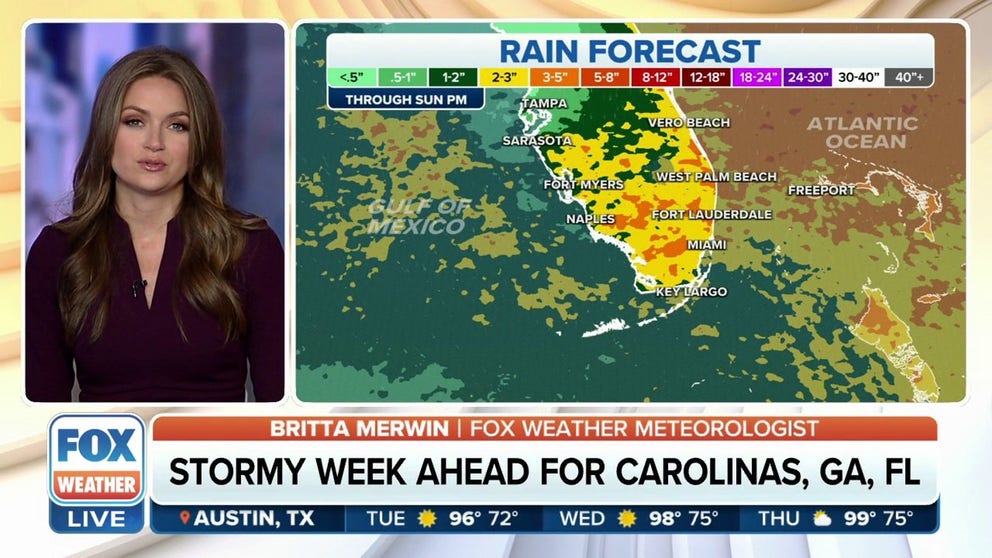
Relentless rain for the Sunshine State
Heavy rain will soak Florida this week, bringing the threat of coastal flooding and dangerous rip currents.
A front will stall over the state and provide storm chances to Florida and the rest of the Southeast through the workweek. North Carolina, South Carolina, Georgia and much of Florida could see several inches of rain by the end of the week.

(FOX Weather)
Hurricane HQ: Forecasters closely monitoring area off the Southeast coast
Speaking of that low, it may try to take on some tropical characteristics as it sits over the warm waters of the Gulf Stream. The National Hurricane Center has outlined the area over the Southeast coast for possible tropical development over the next week, giving it a 30% chance.
"A non-tropical area of low pressure could form near the southeastern coast of the United States late this week," the National Hurricane Center said. "This system could acquire some subtropical characteristics this weekend if it remains offshore while it moves slowly northward or northwestward."
Tropical or not, the low, combined with the high to the north, will lead to increased rain and multiple days of strong onshore winds along Florida's Atlantic coast and up into the coastal Carolinas, the FOX Forecast Center said.

(FOX Weather)
Hurricane Nigel is expected to continue to rapidly intensify over the central Atlantic and is forecast to become a major hurricane on Tuesday.
Nigel is expected to stay clear of North America and continue to move north before taking a northeasterly track.
(FOX Weather)
And further east, a new tropical wave is forecast to emerge off the west coast of Africa by the middle part of next week, according to the NHC. It's expected to gradually develop once it moves off Africa and begins its westward jaunt across the eastern tropical Atlantic.
It has a high chance of development over the next seven days.

(FOX Weather)
Severe weather returns to the Plains
Severe weather chances are returning to the High Plains Tuesday as scattered severe thunderstorms are possible throughout the day on Tuesday.
Areas from North Texas through Oklahoma could see very large hail and severe wind gusts.
Coverage and intensity of the storms will gradually increase as storms march toward the I-35 corridor. The Tuesday evening commute could be disrupted for millions from Wichita, Kansas, to Wichita Falls, Texas. Large hail and damaging wind will be the primary threats, but a tornado or two cannot be ruled out, the FOX Forecast Center said.

(FOX Weather)
Before you go
Here are a few other stories making weather news:
- Dramatic video shows massive shark rescued after becoming stranded on Florida beach
- October solar eclipse 'ring of fire' will happen during Albuquerque International Balloon Fiesta
- Child swept out to sea after freak wave crashes into South African restaurant
Need more weather? Check your local forecast plus 3D radar in the FOX Weather app. You can also watch FOX Weather wherever you go using the FOX Weather app at foxweather.com/live or on your favorite streaming service.
It’s easy to share your weather photos and videos with us. Email them to weather@fox.com or add the hashtag #FOXWeather to your post on your favorite social media platform.