Florida faces days of heavy rain while potential tropical system tries to form off Southeast coast
A potential tropical disturbance could form off the southeastern U.S. coast this weekend, but regardless of development that area of disturbed weather will likely drop several inches of rain from Florida to the Carolinas and into parts of the mid-Atlantic that will be accompanied by gusty winds that could produce large waves, dangerous rip currents and coastal flooding.
Potential tropical trouble for Florida
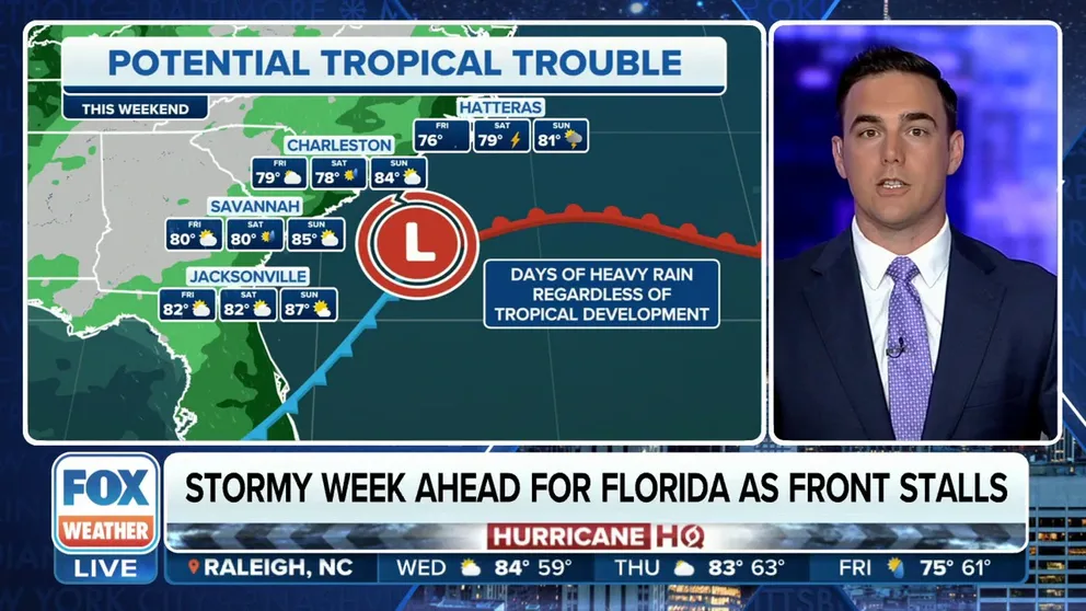
FOX Weather is watching a low that will form on the stationary front keeping Florida soggy this week. The low has the potential of becoming a tropical depression.
It’s called the Sunshine State for a reason, but much of Florida will be missing that big orange glow in the daytime sky as a stationary front parked across the region will spark numerous thunderstorms throughout the week.
And that’s not all, as a potential tropical disturbance could form off the southeastern U.S. coast this weekend.

High tide flooding in Charleston
Seawater flowed through downtown Charleston on Sunday during high tide. Strong onshore winds are piling water at the shore.
But regardless of any tropical development, that area of disturbed weather will likely drop several inches of rain from Florida to the Carolinas and into parts of the mid-Atlantic. Any storms will be accompanied by gusty winds that could help produce large waves, coastal flooding and dangerous rip currents.
And it’s already been a soggy stretch across parts of the Southeast, with flooding reported in Charleston, South Carolina, over the weekend.
Florida bracing for more heavy rain, thunderstorms this week
Florida dries out for the weekend.
(FOX Weather)
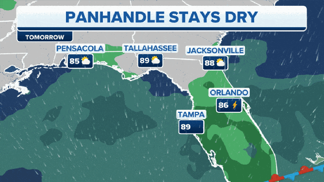
The FOX Forecast Center says a stationary front draped across Florida will help kick off thunderstorms every day this week; each storm capable of producing gusty winds, heavy rain and frequent lightning.
The thunderstorm activity will be more prevalent across South Florida and along areas where sea breeze boundaries develop along the eastern shores.
By the time the week ends, several inches of rain could fall and flooding could occur.
HERE'S WHEN THE SUNSHINE STATE'S RAINY SEASON GETS UNDERWAY

(FOX Weather)
"Now, as this overall pattern persists as we move through the next several days, what’s left of the workweek and into the weekend, the net result of all that, you see all the yellow and orange that’s two to locally as much as five inches of rain in these areas that have been soaked already," said FOX Weather meteorologist Ian Oliver.
Southeast storm could develop into something tropical off the coast
And as we get into the weekend, there is the potential for some tropical activity to develop off the southern coast.
With a strong area of high pressure developing in the north, that will hold the potential system in place over the warm waters off the coast.

(FOX Weather)
The FOX Forecast Center says the clockwise winds around the high interacting with what’s leftover from the stalled out front may begin to produce an area of spin off the eastern coast of Florida.

(FOX Weather)
"The issue, as we move into this point of the (hurricane) season when you have a boundary which is the focus of convection for new showers and thunderstorms occurring over still very warm sea surface temperatures, you can get an area of low pressure to develop," Oliver continued. "As it does so, it may eventually start developing some tropical characteristics – tropical or subtropical, meaning it has characteristics of both."
It’s still unknown if the system will develop, and the National Hurricane Center is giving it a low chance of development over the next week.
"Regardless of subtropical development, this low is likely to bring gusty winds, heavy rain, and high surf conditions to portions of the coastal Carolinas into the coastal Mid-Atlantic states late this week into this weekend," the NHC stated in their tropical advisory.

(FOX Weather)
The FOX Forecast Center said that tropical or not, the low, combined with the high pressure to the north, will lead to heavy rain and several days of gusty winds on the shore along the Atlantic coast of Florida and up into the Carolinas and mid-Atlantic.
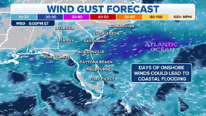
Days of stiff onshore wind will not only create afternoon thunderstorms but also push waves onshore which could mean high tide flooding.
(FOX Weather)
Hazardous beach conditions are expected including large waves, rip currents and coastal flooding.

(FOX Weather)
"Notice how this (rain) spreads up into the mid-Atlantic and through southern parts of the Northeast, areas that have gotten soaked by severe weather, and of course, fringe impacts from Lee last weekend," Oliver said. "So, for that reason, we’ll be watching this."
Coastal areas of the Carolinas could pick up 2-3 inches of rain, but there are parts of North Carolina and Virginia that could see rainfall totals of between 3-5 inches through the end of the weekend.