The Daily Weather Update from FOX Weather: October begins with record warmth expanding across US
Start your day with the latest weather news – The first week of October will feel more like summer in the central and eastern U.S., but a fall storm sweeping across the country will bring cooler temperatures by the end of the week.
Millions in central US brace for record heat as fall makes brief pause
Millions of people in the central U.S. are bracing for some record heat thanks to a blocking pattern that will send temperatures soaring 15 to 25 degrees above average in some areas before the warm temperatures expand farther east later this week.
Welcome to the Daily Weather Update from FOX Weather. It’s Monday, Oct. 2, 2023. Start your day with everything you need to know about today's weather. You can also get a quick briefing of national, regional and local weather whenever you like with the FOX Weather Update podcast.
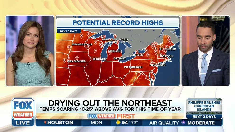
Fall on pause as summerlike warmth expands across US
The calendar might say October, but this week's temperatures will be more typical of summer in the eastern half of the U.S. Record warmth will focus on the Plains and Midwest on Monday before expanding to the Northeast Tuesday and Wednesday. Highs will climb well into the 80s, with some cities even reaching the 90s. These temperatures are 15 to 25 degrees above average for the beginning of October.

(FOX Weather)
First October storm to bring heavy rain, mountain snow and heat relief
One of the season's first fall storms is brewing this week, which is expected to bring some high-elevation snow to the West, heavy rain and the potential for severe weather in the Plains, then a fairly noticeable temperature drop to nearly the entire central U.S. before beginning to lose steam by Thursday.
On Monday, the storm will bring heavy rain to parts of the Four Corners region, along with potentially heavy snow to some of the highest elevations in the Rockies. The rain will expand throughout the day, likely stretching from the Dakotas to New Mexico as a cold front develops off the Rockies. Some severe storms are possible from the Dakotas to West Texas.

(FOX Weather)
Hurricane HQ: Philippe prompts tropical storm alerts for northern Leeward Islands
Tropical Storm Philippe is expected to pass near or just northeast of the northern Leeward Islands through Monday night, prompting a Tropical Storm Watch for the islands of Antigua and Barbuda. Between 4 and 6 inches of rain is expected on those islands, with 2 to 4 inches predicted for the rest of the Leeward Islands. Tropical-storm-force winds (39-plus mph) are also possible on Antigua and Barbuda on Monday.
Philippe is then expected to turn northward and move away from the northern Leeward Islands on Tuesday. The National Hurricane Center forecasts Philippe to strengthen into a hurricane by Thursday or Friday as it moves into the central Atlantic Ocean.
Meanwhile, Tropical Storm Rina is no longer being monitored by the National Hurricane Center as it dissipated overnight several hundred miles to the north-northeast of Philippe.

(FOX Weather)
Before you go
Here are a few other stories you might find interesting.
- Solar eclipse, Orionid meteor shower make October skygazing forecast a standout
- What to expect in tropics as hurricane season enters October
- 7 weather changes to expect in October
Need more weather? Check your local forecast plus 3D radar in the FOX Weather app. You can also watch FOX Weather wherever you go using the FOX Weather app, at foxweather.com/live or on your favorite streaming service.
It’s easy to share your weather photos and videos with us. Email them to weather@fox.com or add the hashtag #FOXWeather to your post on your favorite social media platform.