Daily Weather Update from FOX Weather: Significant severe weather targets 140M, after tornadoes rake Wisconsin
Top weather news for Friday, May 16, 2025: An even more intense day of severe weather is forecast for the Midwest and Ohio valley after tornadoes and damaging wind gusts took out power for hundreds of thousands across Wisconsin and the Great Lakes region on Thursday.
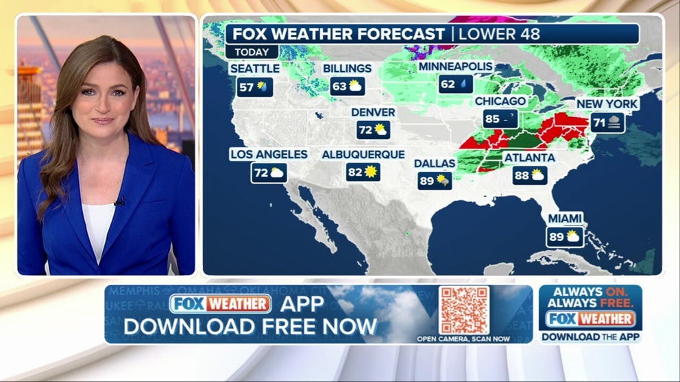
Weather in America: May 16, 2025
FOX Weather has you covered with the breaking forecasts and weather news headlines for your Weather in America on Friday, May 16, 2025. Get the latest from FOX Weather Meteorologist Britta Merwin.
Welcome to the Daily Weather Update from FOX Weather. It’s Friday, May 16, 2025. Start your day with everything you need to know about today's weather. You can also get a quick briefing of national, regional and local weather whenever you like with the FOX Weather Update podcast.
Renewed severe weather outbreak threatens over 140 million with strong tornadoes, extreme gusts
Another significant severe weather outbreak is unfolding across the Midwest and Ohio Valley on Friday, placing more than 143 million people under alert.
The most significant concern for Friday lies in the afternoon and evening hours, where NOAA’s Storm Prediction Center has issued a Level 4 out of 5 risk of severe weather, particularly for southern Illinois, Indiana and Kentucky. This "bull’s-eye" region faces a high potential for strong tornadoes, possibly EF-2 or stronger.
The FOX Forecast Center notes that during the evening hours, several "bow echoes" will move through the northern Tennessee Valley, resulting in extensive wind damage in swaths as gusts exceed 75 mph.
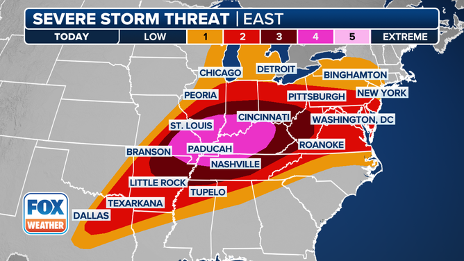
This graphic shows the severe weather threat for May 16, 2025.
(FOX Weather)
Significant tornado damage reported in Wisconsin as severe storms roll through Minneapolis, Chicago
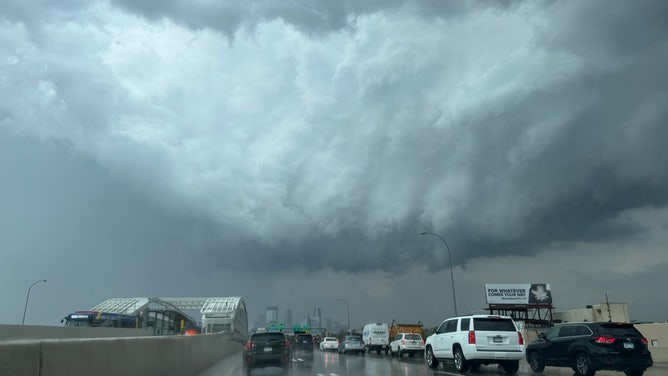
Communities across the Upper Midwest were cleaning up storm damage Friday morning after severe storms spawned damaging wind gusts and even a few tornadoes Thursday evening.
The cities of Juneau and Mayville, Wisconsin, around 60 miles northeast of Milwaukee, received some of the worst damage as tornado-warned storms moved through around 6 p.m. local time. Gusts around Chicago reached nearly 80 mph.
![A potential tornado was spotted just south and east of New Richmond, Wisconsin, late Thursday afternoon.]() Image 1 of 11
Image 1 of 11A potential tornado was spotted just south and east of New Richmond, Wisconsin, late Thursday afternoon. (@mattmain13 / X)
![Ominous clouds over downtown Minneapolis on Thursday, May 15, 2025.]() Image 2 of 11
Image 2 of 11Ominous clouds over downtown Minneapolis on Thursday, May 15, 2025. (@UnitedNathans/X)
![Ominous clouds over downtown Minneapolis on Thursday, May 15, 2025.]() Image 3 of 11
Image 3 of 11Ominous clouds over downtown Minneapolis on Thursday, May 15, 2025. (@UnitedNathans/X)
![Storm clouds loom over Minnesota drivers on Thursday.]() Image 4 of 11
Image 4 of 11Storm clouds loom over Minnesota drivers on Thursday. (@ZachHalverson / X)
![Tornado in New Richmond, Wisconsin]() Image 5 of 11
Image 5 of 11Tornado in New Richmond, Wisconsin (Tara Olson via FOX 9 Minneapolis)
![Hail from East Troy in southeastern Wisconsin.]() Image 6 of 11
Image 6 of 11Hail from East Troy in southeastern Wisconsin. (@AmyM10113 / X)
![Tornado damage in Juneau, Wisconsin]() Image 7 of 11
Image 7 of 11Tornado damage reported in Juneau, Wisconsin on May 15, 2025. (Brian Jansen)
![Tornado damage in Juneau, Wisconsin]() Image 8 of 11
Image 8 of 11Tornado damage reported in Juneau, Wisconsin on May 15, 2025. (Brian Jansen)
![Tornado damage in Juneau, Wisconsin]() Image 9 of 11
Image 9 of 11Tornado damage reported in Juneau, Wisconsin on May 15, 2025. (Brian Jansen)
![Tornado damage in Juneau, Wisconsin]() Image 10 of 11
Image 10 of 11Tornado damage reported in Juneau, Wisconsin on May 15, 2025. (Brian Jansen)
![Tornado damage in Juneau, Wisconsin]() Image 11 of 11
Image 11 of 11Tornado damage reported in Juneau, Wisconsin on May 15, 2025. (Brian Jansen)


Another wet weekend for Northeast and mid-Atlantic as severe storms crash end of week plans
A new cold front from the west will bring yet another round of rain and storms to the Northeast late Friday into Saturday.
A Level 2 out of 5 severe thunderstorm risk exists for the Mid-Atlantic and Northeast Saturday up along the East Coast from North Carolina's outer banks to eastern Connecticut.
Washington, D.C., Philadelphia and New York City are covered in the threat.
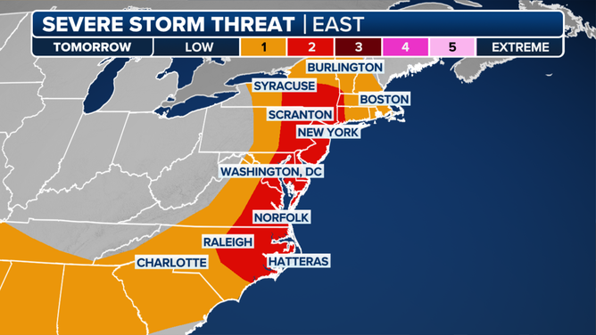
This graphic shows the severe storm threat for Saturday, May 17, 2025.
(FOX Weather / FOX Weather)
Are you a weather wiz?
Put your weather trivia knowledge to the test with our five-question quiz. Click here to get started.

(FOX Weather)
Before you go
Here are a few more stories you might find interesting.
- Watch: 'Fog tsunami' rolls over Lake Michigan, mesmerizing video shows
- Missing woman found after spending weeks surviving alone in California wilderness
- Watch: Navy veteran jumps into rushing Michigan river to save kayaker in distress
Need more weather? Check your local forecast plus 3D radar in the FOX Weather app. You can also watch FOX Weather wherever you go using the FOX Weather app, at FOXWeather.com/live or on your favorite streaming service.