Tornadoes rip through heartland leaving paths of destruction, half a million without power
At least 5 people were killed in weather-related incidents, but that number could fluctuate as first responders continue to check on the hardest impacted areas.
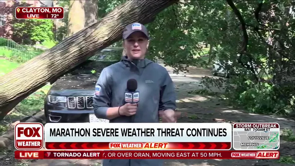
Damage reported in St. Louis metro area after tornado-warned storm
FOX News Multimedia Reporter Olivianna Calmes reports from Clayton, Missouri, where damage has been seen after a tornado-warned storm hit the St. Louis metro area.
PADUCAH, Ky. – Another significant severe weather outbreak unfolded across much of the eastern third of the nation on Friday, with more than 146 million people on alert.
This comes following a turbulent Thursday that saw more than a dozen tornado reports, more than 135 damaging wind incidents and more than 90 reports of large hail across the Upper Midwest.
On Friday afternoon, nearly a million people in the St. Louis metro area were placed under a "Particularly Dangerous Situation" Tornado Warning as a powerful thunderstorm moved through.
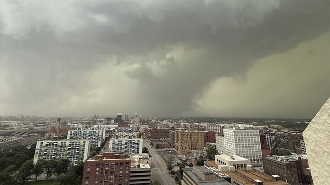
An ominous cloud formation is seen in the St. Louis metro as a tornado-warned storm moved through the city May 16, 2025.
(Sean Malone/KMOX News / FOX Weather)
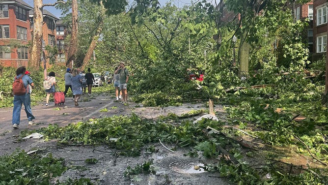
Trees and power lines were reported down across the metro, with more than 100,000 customers in the dark due to the severe weather.
Most of the damage was concentrated on the western and northern sides of St. Louis, which could be indicative of a twister's track.
Emergency management reported responding to dozens of calls for service, which included damaged roofs and partial building collapses.
Video from the St. Louis Arch showed the supercell cutting through the metro, but if there was a tornado, it was likely rain-wrapped and difficult to see.
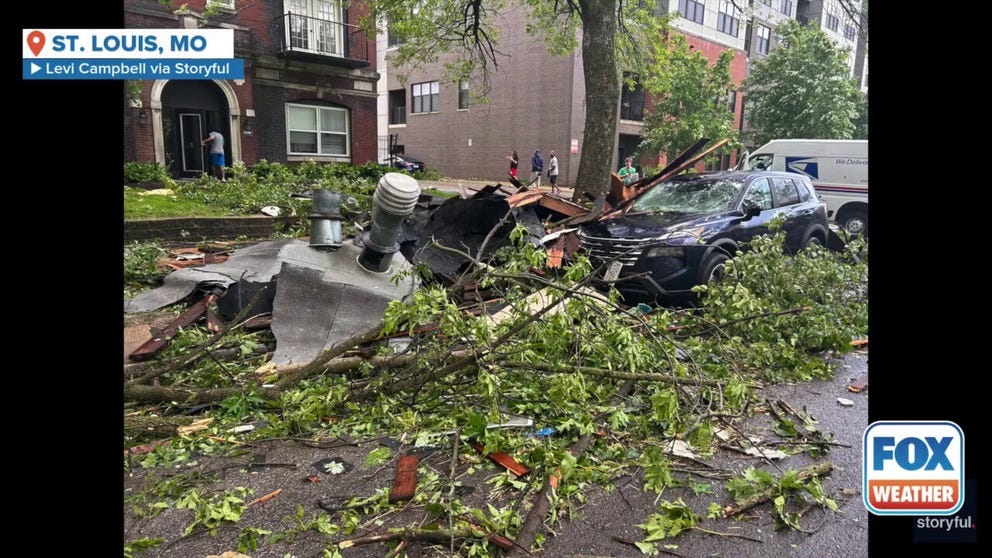
Powerful winds send trees, debris down St. Louis street
Footage shot on Friday afternoon shows powerful winds in St. Louis, Missouri, hurling brush and debris down Pershing Avenue.
St. Louis Mayor Cara Spencer shared five people were killed in weather-related incidents and over 5,000 homes were affected.
That number could fluctuate as first responders continue to check on the hardest impacted areas.
LIVE STORM TRACKER: SEVERE WEATHER MAPS, RADAR, HAIL POTENTIAL, TORNADO THREATS, AND MORE
In addition to the tornado threat, large hail was also seen across the region.
The Missouri State Emergency Management Agency said destructive 2-3" hail stones were observed.
The National Weather Service office that services the St. Louis metro believes that many of the severe weather reports are from damaging wind gusts but will be in the field on Saturday to determine if any tornadoes touched down.
The severe weather could not have occurred at a worst time for the metro, as many traffic lights were knocked out of service for Friday's evening rush.
![Large hail in Missouri on 5/16/2025]() Image 1 of 9
Image 1 of 9Large hail in Missouri on 5/16/2025 (Willow Springs FD & Pulaski Co EM)
![Large hail in Missouri on 5/16/2025]() Image 2 of 9
Image 2 of 9Large hail in Missouri on 5/16/2025 (Willow Springs FD & Pulaski Co EM)
![An ominous cloud formation is seen in the St. Louis metro as a tornado-warned storm moved through the city May 16, 2025.]() Image 3 of 9
Image 3 of 9An ominous cloud formation is seen in the St. Louis metro as a tornado-warned storm moved through the city May 16, 2025. (Sean Malone/KMOX News)
![An ominous cloud formation is seen in the St. Louis metro as a tornado-warned storm moved through the city May 16, 2025.]() Image 4 of 9
Image 4 of 9An ominous cloud formation is seen in the St. Louis metro as a tornado-warned storm moved through the city May 16, 2025. (Sean Malone/KMOX News)
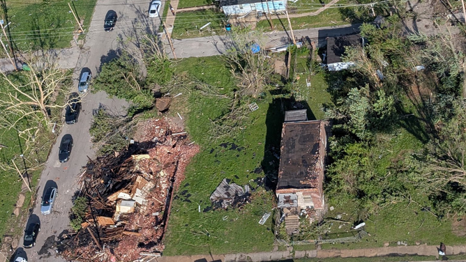
![Storm damage is seen in University City, Missouri, near St. Louis, on May 16, 2025.]() Image 5 of 9
Image 5 of 9Storm damage is seen in University City, Missouri, near St. Louis, on May 16, 2025. (Kurt/X)
![Storm damage is seen in the Forest Park neighborhood of St. Louis, Missouri, on May 16, 2025.]() Image 6 of 9
Image 6 of 9Storm damage is seen in the Forest Park neighborhood of St. Louis, Missouri, on May 16, 2025. (Aishah French)
![Storm damage is seen in Clayton, Missouri, near St. Louis, on May 16, 2025.]() Image 7 of 9
Image 7 of 9Storm damage is seen in Clayton, Missouri, near St. Louis, on May 16, 2025. (timconttreras25/X)
![An uprooted tree is seen in Clayton, Missouri, near St. Louis, on May 16, 2025.]() Image 8 of 9
Image 8 of 9An uprooted tree is seen in Clayton, Missouri, near St. Louis, on May 16, 2025. (timconttreras25/X)
![Tornado damage around St. Louis, Missouri]() Image 9 of 9
Image 9 of 9Tornado damage around St. Louis, Missouri (St. Louis, MO Police)


A hard-hit area was around the city's zoo, but staff said all guests and animals were accounted for.
The zoo was expected to remain closed through at least Saturday for clean-up.
Further south, significant tornado damage was also reported in Scott County, where first responders were in search and rescue mode on Friday for missing people.
HOW TO WATCH FOX WEATHER
Tornadic thunderstorms also impacted Indiana, where several counties south of Interestate 70 were placed under Tornado Warnings.
The mayor of Bloomington, Indiana said police were in search and rescue mode on Friday evening, but it would likely be several hours before the all-clear would be given.
The SPC received more than half a dozen reports of tornado touchdowns in the Hoosier State, but there were no reports of any fatalities connected to the severe weather.
And in Virginia, Fairfax County Emergency Management reported two people were dead from weather-related crashes.
Overall, more than half a million were reported without power across at least a dozen states, with outages likely to last days in hard-hit communities.

Tornado spotted in progress in southern Missouri
A tornado was spotted by a team of FOX Weather Exclusive Storm Trackers crossing through southern Missouri, near Bell City,
The storm system also triggered Dust Storm Warnings on the south side of Chicago along Interstate 80.
NWS meteorologists advised drivers in Northern Illinois to exercise caution if venturing out in the gusty winds.
"A dust storm continues to race across the Chicago metro resulting in near zero visibility and hazardous travel. Dust will continue north over the next couple hours. Isolated storms are also developing in northeast IL which may result in damaging winds," forecasters stated.
Severe storm threat continues through early next week
If storms can maintain their strength overnight, they could impact parts of the mid-Atlantic and Northeast on Saturday. Damaging wind gusts look to be the largest threat, the FOX Forecast Center said.
SEE IT: HUGE WALL OF DUST LOOMS OVER NEBRASKA FIELD
Another wave of severe weather will move across the central U.S. The Storm Prediction Center has highlighted the potential of severe weather in several areas of the country through early next week.
"This is a classic severe weather setup for the Central Plains," Merwin said. "You have all of that moisture streaming in from the Gulf, the cooler, drier air off the Rockies, and then you get that classic clash zone."
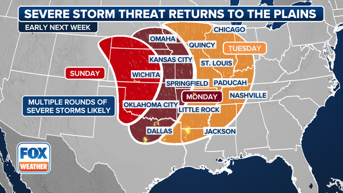
This graphic shows a severe weather threat starting on Sunday, May 18.
(FOX Weather)