Significant tornado damage reported in Wisconsin as severe storms roll through Minneapolis, Chicago
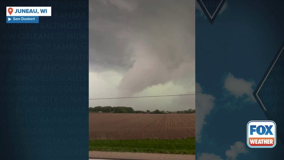
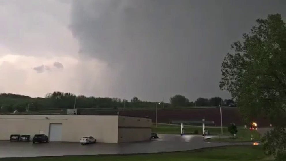
Significant damage was reported by first responders around Juneau and Mayville, Wisconsin, as a line of tornado-warned storms raced through on Thursday evening.
Tornadoes, severe weather tear through Upper Midwest
Radar-confirmed tornadoes tore through parts of Western Wisconsin on Thursday. Dozens of tornado warnings were issued throughout Minnesota and Wisconsin.
MAYVILLE, Wis. – Communities across the Upper Midwest were cleaning up storm damage Friday morning after severe storms spawned damaging wind gusts and even a few tornadoes Thursday evening.
Tornado Warnings wailed across Minneapolis and nearby communities on Thursday afternoon, and tornadoes were spotted spinning through Minnesota and Wisconsin, as dangerous storms charged through the region.
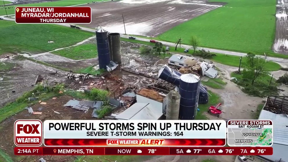
The cities of Juneau and Mayville, Wisconsin, around 60 miles northeast of Milwaukee, received some of the worst damage as tornado-warned storms moved through around 6 p.m. local time.

Tornado-warned storms leave behind trail of damage in Juneau, Wisconsin
Significant damage was reported by first responders around Juneau and Mayville, Wisconsin, as a line of tornado-warned storms raced through on Thursday evening.
The Dodge County Sheriff's Office said multiple buildings were destroyed in both cities and one person was taken to the hospital for minor injuries.
Tornado spotted in southern Wisconsin
A tornado was spotted in Juneau, Wisconsin, on Thursday.
Photos from around Juneau showed significant damage to farms, with trees and debris that blocked roadways.
The Mayville Fire Department reported responding to numerous gas leaks as well as buildings that had structural damage.
Tornado sirens blare in Wisconsin ahead of supercell
A tornado around Mayville, Wisconsin, caused significant damage on Thursday.
Emergency crews reported responding to numerous calls for injuries, but few people required transport to medical centers.
At least two shelters were opened for residents whose homes were significantly damaged during the severe weather event.
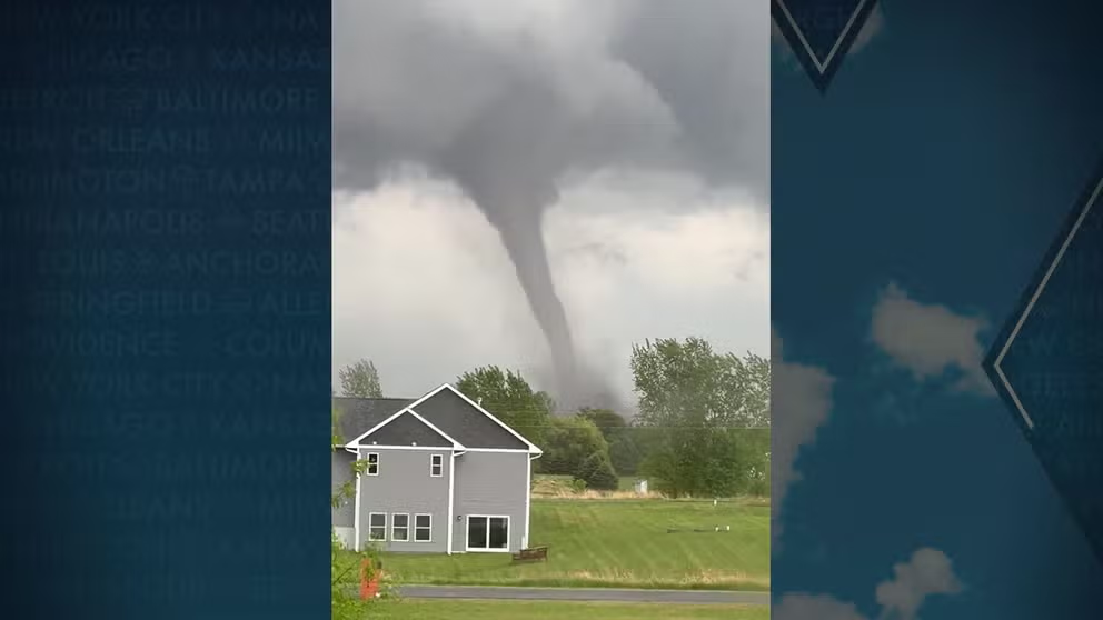
Tornado rolls by homes in New Richmond, Wisconsin
A tornado swirled near a neighborhood in New Richmond, Wisconsin on May 15, 2025.
Significant power outages remained in Dodge, Fond du Lac and Sheboygan counties, and officials said power outages could last for several days as many utility poles were snapped by the intense winds.
![A potential tornado was spotted just south and east of New Richmond, Wisconsin, late Thursday afternoon.]() Image 1 of 11
Image 1 of 11A potential tornado was spotted just south and east of New Richmond, Wisconsin, late Thursday afternoon. (@mattmain13 / X)
![Tornado damage in Juneau, Wisconsin]() Image 2 of 11
Image 2 of 11Tornado damage reported in Juneau, Wisconsin on May 15, 2025. (Brian Jansen)
![Tornado damage in Juneau, Wisconsin]() Image 3 of 11
Image 3 of 11Tornado damage reported in Juneau, Wisconsin on May 15, 2025. (Brian Jansen)
![Ominous clouds over downtown Minneapolis on Thursday, May 15, 2025.]() Image 4 of 11
Image 4 of 11Ominous clouds over downtown Minneapolis on Thursday, May 15, 2025. (@UnitedNathans/X)
![Ominous clouds over downtown Minneapolis on Thursday, May 15, 2025.]() Image 5 of 11
Image 5 of 11Ominous clouds over downtown Minneapolis on Thursday, May 15, 2025. (@UnitedNathans/X)
![Storm clouds loom over Minnesota drivers on Thursday.]() Image 6 of 11
Image 6 of 11Storm clouds loom over Minnesota drivers on Thursday. (@ZachHalverson / X)
![Tornado in New Richmond, Wisconsin]() Image 7 of 11
Image 7 of 11Tornado in New Richmond, Wisconsin (Tara Olson via FOX 9 Minneapolis)
![Hail from East Troy in southeastern Wisconsin.]() Image 8 of 11
Image 8 of 11Hail from East Troy in southeastern Wisconsin. (@AmyM10113 / X)
![Tornado damage in Juneau, Wisconsin]() Image 9 of 11
Image 9 of 11Tornado damage reported in Juneau, Wisconsin on May 15, 2025. (Brian Jansen)
![Tornado damage in Juneau, Wisconsin]() Image 10 of 11
Image 10 of 11Tornado damage reported in Juneau, Wisconsin on May 15, 2025. (Brian Jansen)
![Tornado damage in Juneau, Wisconsin]() Image 11 of 11
Image 11 of 11Tornado damage reported in Juneau, Wisconsin on May 15, 2025. (Brian Jansen)


"Things can be replaced, but people can't," Dodge County Sheriff Dale Schmidt said during an evening news briefing.
Tornadoes were also reported in New Richmond, Wisconsin, and Danvers, Minnesota, and appeared to be rope-like in appearance, according to storm spotters.
Most storm reports received by the Storm Prediction Center were from hail, which reached upwards of hen egg-sized in the Badger State.
Video taken in downtown Madison, Wisconsin, showed ice pelting balconies during the first round of storms.
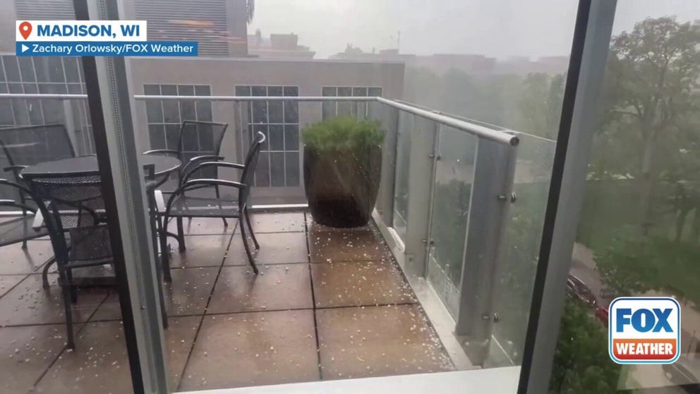
Hail pings off windows in Wisconsin
Storms dumped rain and hail on Madison, Wisconsin, on Thursday.
Tornado sirens sound in Minneapolis, Chicago slammed by fierce wind
Severe weather also plagued the Minneapolis and Chicago metro areas as the line of storms swept through. A thunderstorm with rotation prompted a Tornado Warning for the Minneapolis metro on Thursday afternoon, according to the National Weather Service.
Following the warning, there were no confirmed tornado touchdowns in the metro, with sightings outside the Twin Cities.
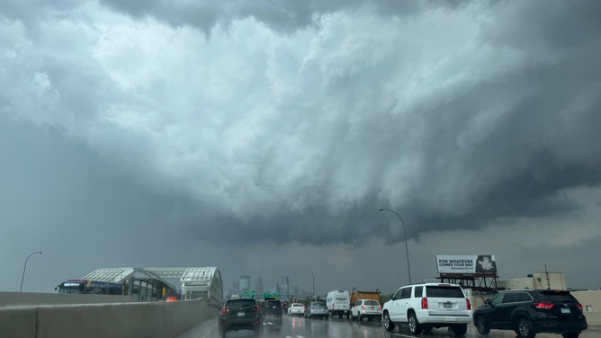
Storm clouds loom over Minnesota drivers on Thursday.
(@ZachHalverson / X / FOX Weather)
Damaging winds, including a gust close to 80 mph in Chicago, tore through the Upper Midwest.
As a precautionary measure, a concert starring Beyoncé at Soldier Field in Chicago was pushed back from a 7 p.m. to a 9 p.m. start time in order to allow the worst of the weather to push through.
Shortly after 7 p.m. concertgoers received warnings from the local National Weather Service to seek shelter as severe storms with plenty of lightning and gusty winds moved through the Windy City.

Torrential rains soak concertgoers at Beyonce Chicago performance
Severe thunderstorms brought heavy rains and blasting winds to Chicago's Soldier Field as thousands waited to see Beyonce's Cowboy Carter tour. Stadium officials had delayed the start of the concert two hours to allow te
Both Midway and O’Hare airports reported significant delays as a line of storms rumbled through the area.
The National Weather Service received widespread reports of trees snapped or toppled across much of the Chicago metro area.
Over 300,000 lose power as damaging wind gusts sweep Michigan, Indiana
The storms transformed into an intense squall line as they marched east into Michigan and Indiana on Thursday night, carrying a wall of wind that led to damage reports across much of the state.
Southwestern Michigan and northwestern Indiana took the brunt of the gusts, which reached over 60-70 mph and left over 300,000 electricity customers without power, according to findenergy.com. Multiple wind damage reports came to the NWS from the Grand Rapids, Kalamazoo and Battle Creek areas.
"(Kalamazoo Department of Public Safety) is conducting a storm damage assessment and responding to numerous calls of wires and trees down in multiple parts of the city," city officials wrote in a Facebook post.

Severe storms trigger powerflashes in Kalamazoo, Michigan
Electric video captured the moments power lines exploded as severe storms thundered across Kalamazoo, Michigan Thursday night. Electricity was still out to more than 250-thousand customers across the state on Friday morning. A top wind gust of 66 mph was clocked in Kalamazoo.
Wind gusts knocked over a semi-truck along U.S. Highway 127 near Mason, according to the NWS.
Springfield, Michigan recorded a gust of 76 mph while Grand Haven reached 70 mph.
Friday's severe weather threat increases

(FOX Weather)
The severe weather threat is continuing to increase as we head into Friday, with more than 6 million people in cities like Bloomington, Indiana, St. Louis, and Louisville, Kentucky, and Clarksville, Tennessee, in a Level 4 out of 5 threat.
RENEWED SEVERE WEATHER OUTBREAK THREATENS OVER 140 MILLION FRIDAY
A lesser Level 3 out of 5 threat is in place for major cities, including Indianapolis, Nashville, Cincinnati and Knoxville.
Storms, however, could erupt across a wide swath of the U.S. from Texas to the Northeast.