First of two powerful cross-country storms underway, millions under severe weather and flood threat
Potential weekend washout for most of the Mid-Atlantic and Northeast, where rain is expected to begin Friday.

A cross-country storm is expected to impact parts of the U.S.
A cross-country storm is putting over 30 states on notice, with tornado warnings issued in Oklahoma and Missouri.
The first of two back-to-back cross-country storms is moving out of the Four Corners region and pushing east Thursday. Combined, these systems are set to deliver heavy rain to millions across most of the country east of the Mississippi River, as well as a severe weather threat to parts of the central U.S. and Deep South, while the potential for flash flooding develops across the Tennessee Valley on Friday.
ROUNDS OF SNOW TO STRETCH FROM FOUR CORNERS TO THE GREAT LAKES, TRIGGERING WINTER WEATHER ALERTS
Meanwhile, a potential weekend washout looms for most of the Mid-Atlantic and Northeast, as rain reaches the region Friday.

Warning boxes are color coded as: Severe Thunderstorm Warnings in yellow, Tornado Warnings in red, Tornado Warnings with confirmed tornado in purple, Flash Flood Warnings in green, and Flash Flood Emergencies in pink.
(FOX Weather)
Thursday: Tornado rips through Plains, as first storm begins cross-country sprint
Ahead of the first cross-country system, a cold front delivered downpours across parts of Oklahoma, Missouri and Kansas Thursday morning before thunderstorms clustered together in a fast-moving line, producing a tornado that knocked out power to parts of Purcell, Oklahoma.
A Tornado Watch was in effect for parts of Oklahoma, Arkansas and Missouri through Thursday morning.

A radar-confirmed tornado ripped across Interstate 35 and part of Purcell, Oklahoma Thursday morning, knocking down power lines as a powerful line of thunderstorms barreled their way across the Southern Plains.
(KWTV/KOTV via NNS / FOX Weather)
More severe storms are possible Thursday across the Mississippi River Valley from St. Louis to Oklahoma City and as far south as Monroe, Louisiana.
Damaging wind gusts are the main threat, but more tornadoes could form.
The first cross-country storm will sprint through the Midwest through Thursday and a widespread area of rain will cover Chicagoland in Illinois, Wisconsin and Indiana and reach into parts of the Ohio Valley into the evening.

(FOX Weather)
Friday: Severe weather threat for Deep South, as second storm takes shape
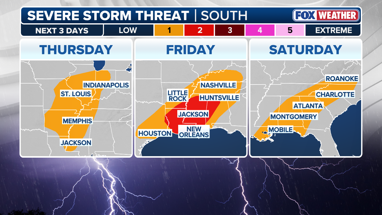
A cold front associated with the first storm will move into the Deep South on Friday, sparking the potential for the most significant severe weather threat this week.
NOAA's Storm Prediction Center has issued a Level 2 out of 5 risk of severe thunderstorms for an area covering more than 7 million people across the Lower Mississippi and Tennessee valleys, including parts of west Tennessee, Arkansas, Mississippi, Alabama and Louisiana.
This covers Memphis, Tennessee, Jackson, Mississippi and Baton Rouge, Louisiana. These storms could be capable of generating damaging wind gusts, hail and possibly tornadoes.
(FOX Weather)
On Friday, the second cross-country storm will develop once again in the Four Corners and move out of the southern Rockies, bringing another round of rain to many of the same places as the first storm in the Midwest, and in the Mississippi and Tennessee valleys.
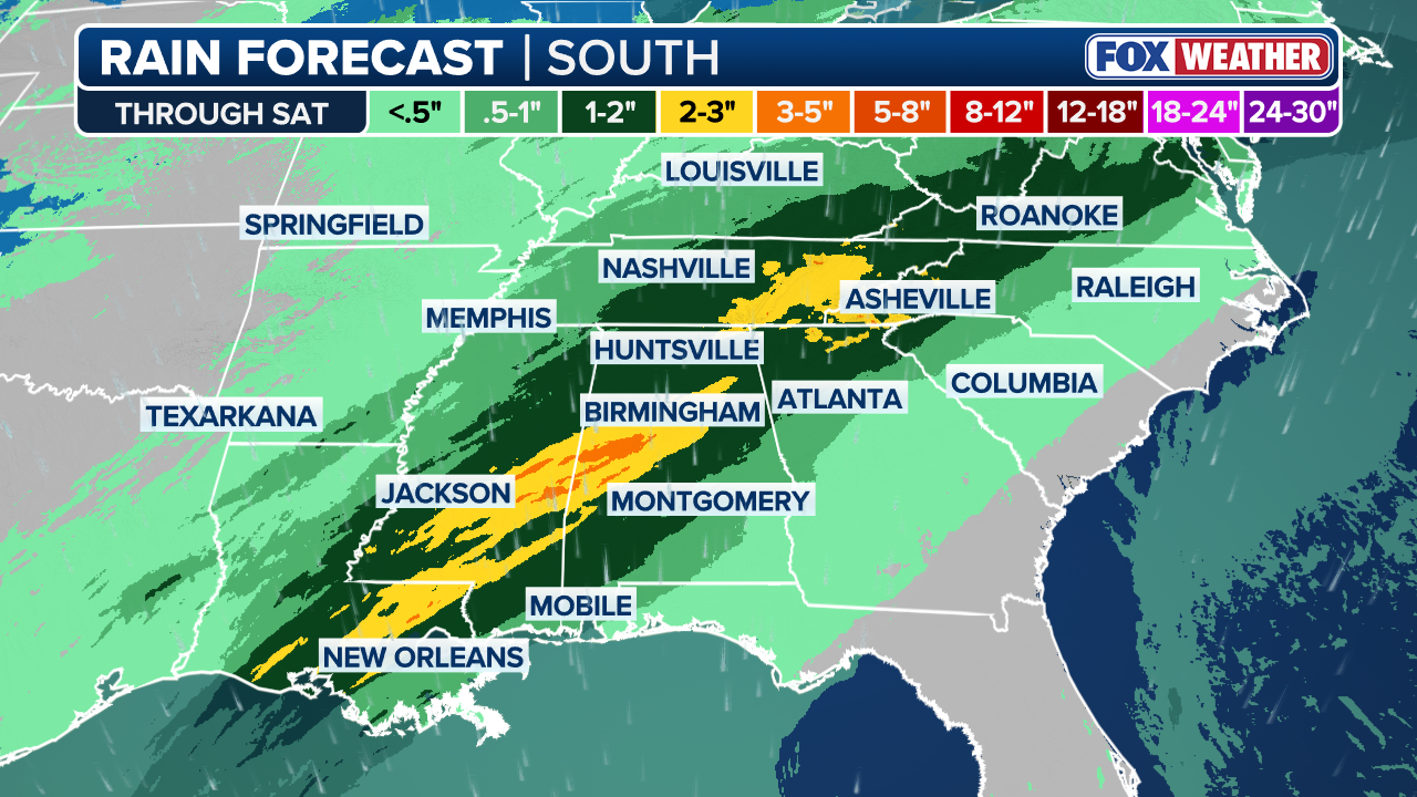
NOAA's Weather Prediction Center has issued a Level 2 out of 4 threat of flash flooding for Middle Tennessee, Mississippi and northern Alabama through Saturday, where 2-3 inches of rain is expected with localized pockets of up to 5 inches possible.
Flood Watches have been issued for all of Middle Tennessee and Northern Alabama on Friday, including the Nashville and Huntsville, Alabama metro areas.

(FOX Weather)
Storms are expected to linger over the region through Saturday morning.
Meanwhile, rain from the first storm will arrive in the Northeast and New England, including Washington, D.C., Philadelphia, New York City and Boston Friday morning.
Weekend: Washout for the East Coast
As the second storm shifts into the Great Lakes region by Saturday afternoon, showers and thunderstorms are expected across much of the Northeast and New England coasts through the day.
(FOX Weather)
Conditions are expected to improve by late Sunday, with most areas drying out by Monday.