How La Niña, Polar Vortex winds could fuel a fast-start to brutal winter for parts of the US
According to the FOX Forecast Center, two weather patterns, La Niña and an easterly Quasi-Biennial Oscillation, indicate a frigid start to December for the Eastern U.S.
La Niña and Quasi-Biennial Oscillation suggest cold start to December
Next week's pre-winter arctic plunge might be a sign of things to come for the Eastern U.S., as several key weather patterns specifically, La Niña and an easterly Quasi-Biennial Oscillation, signal early season bone-chilling cold and the potential for more snowstorms to the region.
Next week's pre-winter arctic plunge might be a sign of things to come for the Eastern U.S., as several key weather patterns will converge to bring early bone-chilling cold and potentially more snowstorms to the region.
FIRST TASTE OF LA NIÑA WINTER AHEAD WITH BIG FREEZE AND SNOW ON THE WAY FOR MILLIONS OF AMERICANS
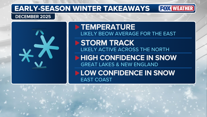
The Eastern U.S. will likely see a colder than average start to winter this December.
(FOX Weather / FOX Weather)
According to the FOX Forecast Center, two weather patterns, La Niña and an easterly Quasi-Biennial Oscillation, will allow more rounds of arctic air that is typically trapped high above the North Pole to spill into the lower levels of the atmosphere and south into the Eastern U.S.
WHAT ARE EL NINO AND LA NINA CLIMATE PATTERNS?
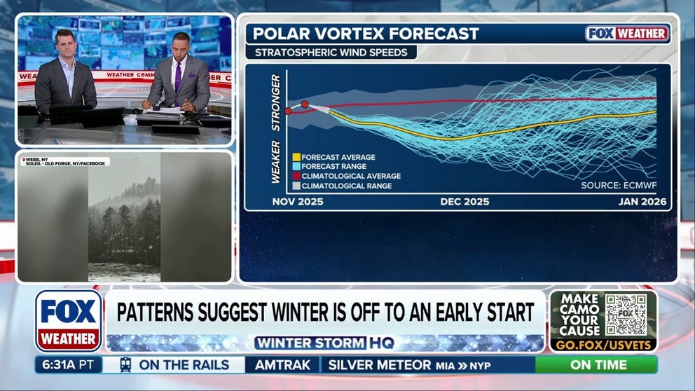
This frigid air is known as the "Polar Vortex." Air in the polar vortex sits in the stratosphere, some 10 to 30 miles above the Earth's poles and intensifies during the winter, when a lack of sunlight cools air at this height to below -70 degrees Celcius.
The polar vortex typically remains locked over the North Pole and Northern Canada as well as up in the stratosphere, separated from warmer air in the lower level of the atmosphere, the troposphere—that makes up the weather we experience.
![The QBO weakens the polar vortex allowing frigid air into the lower levels of the atmosphere.]() Image 1 of 2
Image 1 of 2The QBO weakens the polar vortex allowing frigid air into the lower levels of the atmosphere. (FOX Weather)
![This graphic shows how the QBO interacts with La Niña to produce cold conditions over the Eastern U.S. during winter.]() Image 2 of 2
Image 2 of 2This graphic shows how the QBO interacts with La Niña to produce cold conditions over the Eastern U.S. during winter. (FOX Weather)
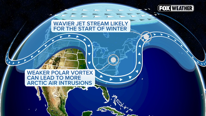
While the El Niño–Southern Oscillation (ENSO) is typically the driver of most weather, another lesser-known climate pattern, the Quasi-Biennial Oscillation (QBO) will play a big role early this winter.
The QBO refers to the direction winds are blowing in the stratosphere around the equator, which in turn will influence the strength of the Polar Vortex.
The current easterly phase of the QBO will weaken the barrier surrounding the Polar Vortex, allowing that ice-cold air to infiltrate the lower levels of the atmosphere.
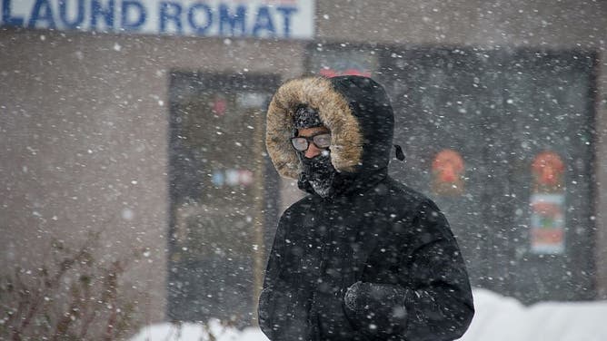
FILE - A man is bundled up against the cold as he walks in the street during a snowstorm in Washington, DC, on January 23, 2016. A deadly blizzard with bone-chilling winds and potentially record-breaking snowfall slammed the eastern US on January 23, as officials urged millions in the storm's path to seek shelter -- warning the worst is yet to come. US news reports said at least eight people had died by late Friday from causes related to the monster snowstorm, which is expected to last until early Sunday.
(NICHOLAS KAMM/AFP via Getty Images)
WHAT ARE THE 5 LAYERS OF OUR ATMOSPHERE?
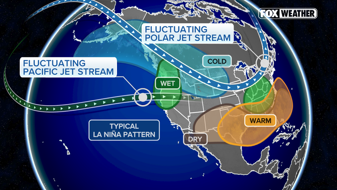
Meanwhile, La Niña typically creates more dips in the Pacific jet stream, which will allow that cold air sitting over Canada to spill south into the Eastern U.S.
The FOX Forecast Center has found that years when both La Niña and an easterly QBO were present were much colder than average across the East.
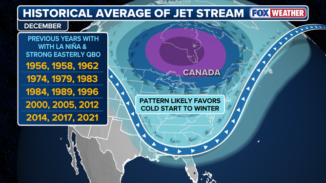
Previous years with La Niña and a strong easterly QBO featured colder than average Decembers.
(FOX Weather)
Snow-cember?
While the exact frequency and intensities of snowstorms are impossible to predict, the presence of cold air will turn storms that move across the country from rainmakers into snowmakers.
La Niña also typically brings snowstorms to the Northern Tier during winters, while the southern part of the country typically stays warm and dry.
The upshot is that forecasters are confident that the areas around the Great Lakes in the Upper Midwest and Northeast, as well as New England, will see more snow than usual this December.
HOW MUCH WILL IT SNOW ACROSS AMERICA? EARLY FLAKE OUTLOOK FOR BREWING LA NIÑA WINTER
Meanwhile, any coastal storms that form in the presence of arctic air will be strong snow-producing nor'easters.
While future storm tracks are uncertain, forecasters are increasingly sure that millions across the East will be reaching for a warm beverage to start this winter.