Cold front to usher in cooler temperatures this week following severe weather threat
Some parts of the country could see a temperature drop between 10 to 20 degrees this week.
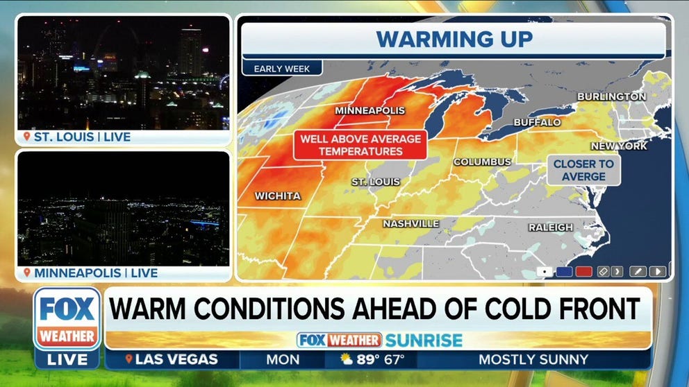
Warm conditions ahead of cold front that will send temperatures plunging later in week
The front will arrive Wednesday through Thursday, once again sending temperatures plunging nearly 30° over the course of 24 hours.
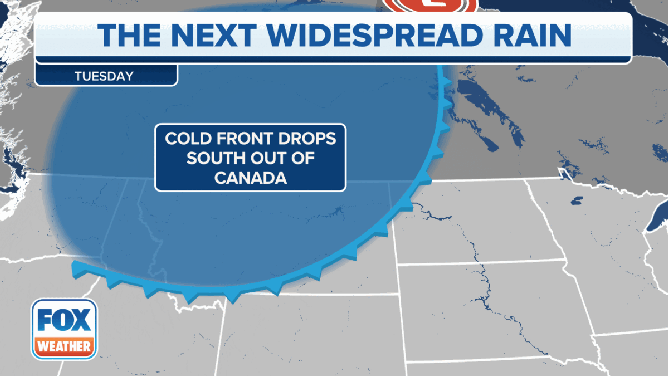
The FOX Forecast Center is tracking another cold front expected to sweep across the eastern half of the country this week that will bring in cooler temperatures and could produce some severe weather and heavy rain along its journey.
Ahead of the front, however, temperatures will remain mild.
HOW TO WATCH FOX WEATHER ON TV
"High pressure filtered in behind the cold front this weekend, and it really dropped those temperatures," FOX Weather meteorologist Jane Minar said. "But some of us are starting to see that rebound early this week."
Once the area of high pressure slides off the East Coast, southerly winds will pull warmer air from the Gulf of Mexico up to the Great Lakes region.
"What it's going to do is raise those temperatures above average," Minar said. "We're talking anywhere between 10 to 20 degrees warmer to start the week."
A cold front will usher in cooler temperatures and the chance of severe weather this week.
(FOX Weather)
But it's not going to last.
"Because of a cold front that is going to be tracking from corner to corner across the country this week," Minar said. "We're going to start tracking it tonight to get all the way off the East Coast by Friday."
The cold front will begin sweeping in from the north starting on Tuesday, and once the front moves through, temperatures will be much cooler behind it.
Warm air from the Gulf of Mexico will collide with the advancing cold front, which could lead to severe weather in the Plains and parts of the Midwest on Tuesday and then into the Mississippi and Ohio valleys and the southern Great Lakes region.
FALL IS THE SECOND SEVERE WEATHER SEASON
Temperature tumble

(FOX Weather)
Most areas in the eastern half of the U.S. won't begin to notice a difference in temperatures until later this week, but behind the front, temperatures will tumble.
Rapid City, South Dakota, and Minneapolis, for example, will only make it into the mid- to upper 50s on Wednesday afternoon.
But cities ahead of the front, like St. Louis, Kansas City and Dodge City, Kansas, will enjoy temperatures in the lower to mid-70s.
Millions of Americans from New England to the Northeast and mid-Atlantic will also enjoy temperatures in the 70s.
DISCOVER FALL FOLIAGE AND WHERE TO SEE THE FALL FOLIAGE

(FOX Weather)
The front will continue to race across the eastern half of the country by Thursday, and more areas behind it will begin to feel the chill.
Minneapolis will fall again to around 50 degrees during the afternoon, and Chicago will see about a 10-degree temperature difference between Wednesday and Thursday. The Windy City will likely only see a high temperature of about 56 degrees.
Temperatures in the upper 50s will extend into the Great Lakes and Ohio Valley.
Areas along the East Coast, like New York City and Baltimore, will see another day with temperatures in the upper 60s.
FALL DRIVING WARNING: WET LEAVES CAN BE AS SLIPPERY AS ICE

(FOX Weather)
The front will finally push through New England, the Northeast and East Coast on Friday, and that's when some cooler temperatures will be felt in those regions.
It will remain mild in places like New York City and Baltimore, but in Syracuse, New York, temperatures will only hover in the upper 50s.
And it's not only the cooler temperatures that will make it feel like fall and winter.
Some heavy rain is expected in the Northeast, and that will lead to some gloomy conditions that will last into at least the first part of the weekend.

(FOX Weather)