Coast-to-coast warmth to ring in climatological spring
Many areas of the country could be 20 to 30 degrees above average by the middle of the week
Coast-to-coast warmth to ring in climatological spring this week
Temperatures could be 30 degrees above average in some parts of the country.
Climatological spring begins Tuesday, and what could be better than a coast-to-coast warmup to mark the occasion?
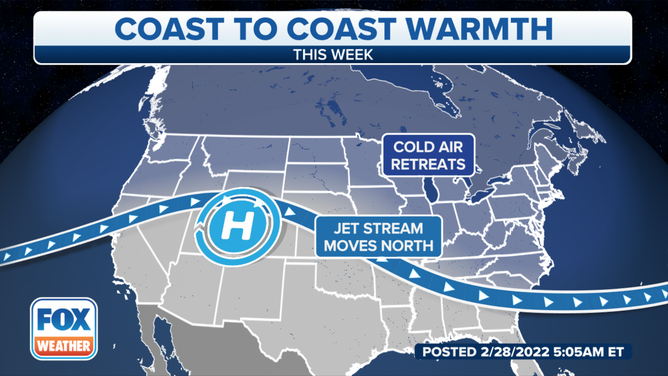
The jet stream will begin to lift to the north this week.
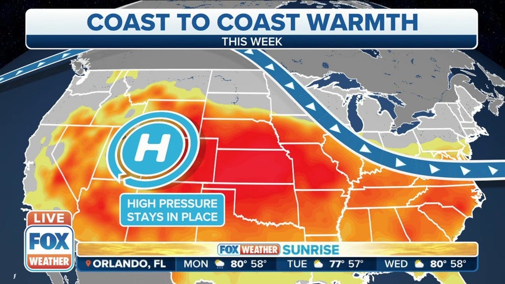
The jet stream has been parked over the northern tier of the country, and that has been allowing the cold air to remain in place.
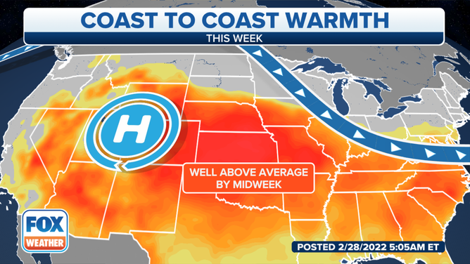
Above-average temperatures will move in by midweek.
However, as the week continues, the jet stream will retreat northward into Canada, which will help a ridge of high pressure develop over the Four Corners in the southwestern U.S.
The high-pressure system will remain in place, which will help temperatures rise to as much as 20 to 30 degrees above average for many areas of the country.
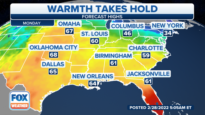
High temperatures on Monday.
Most of the country will feel the springlike temperatures starting Monday, except for the Northeast and New England, where temperatures will remain in the 30s. South Florida will also remain much warmer than the rest of the country.
Temperatures will be in the mid- to upper 60s in the Plains from Omaha, Nebraska, to Oklahoma City and Dallas.
New Orleans and other areas along the Gulf Coast will also enjoy temperatures in the 60s.
PARTY ON: RAIN DIDN'T STOP MARDI GRAS CELEBRATIONS IN NEW ORLEANS
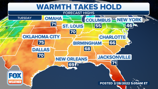
High temperatures on Tuesday.
By Tuesday, temperatures will be even warmer in the eastern half of the country. Temperatures will be in the 70s from the Plains into the Mississippi and Tennessee valleys. At the same time, areas of the Ohio Valley into the mid-Atlantic, Northeast and New England will start to get in on the action.
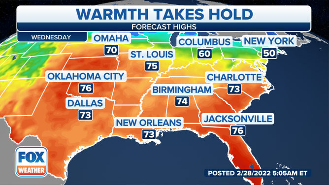
High temperatures on Wednesday.
Wednesday is more of the same, as areas from the Plains to the Southeast will be enjoying temperatures in the 70s.
And while the Ohio Valley, Northeast and New England won't be as warm, temperatures will be above average for this time of year.
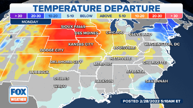
Temperatures will be well above average for many parts of the country this week.
Temperatures in the central part of the country will be 20 to 30 degrees above average all week, while the Northeast will be 20 to 30 degrees below average on Monday. The warmer air will move into that region by midweek.
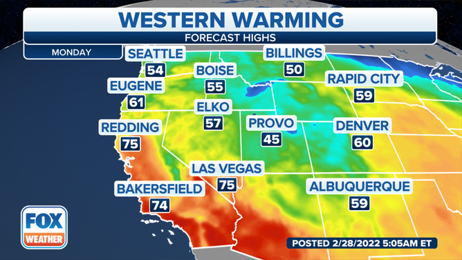
High temperatures on Monday.
(FOX Weather)
The country's western half will also enjoy the warmer temperatures, but it will take a few days to get there.
IT'S A ‘GULLY-WASHER’ AND OTHER WAYS SOME PEOPLE SAY IT'S RAINING
Monday will be cooler in the northern half of the country. Seattle is expected to be around 54 degrees with rain through the week.
Southern California and southwestern Arizona will be the warmest spots on Monday.
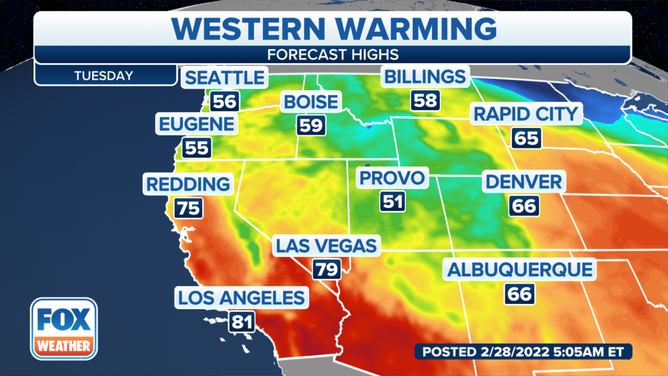
High temperatures on Tuesday.
(FOX Weather)
Temperatures will begin to rise on Tuesday. Denver, which is forecast to be around 60 degrees on Monday, has a forecast high on Tuesday of 66 degrees.
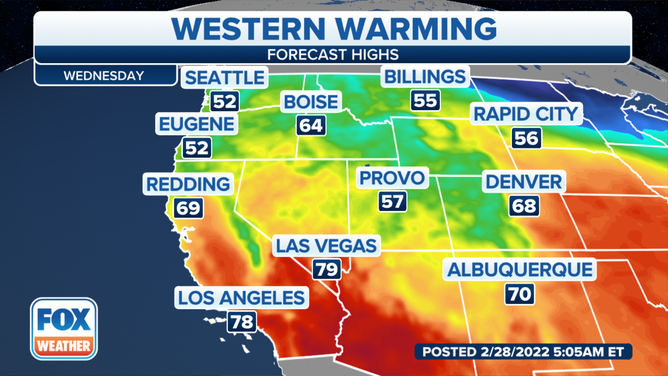
High temperatures on Wednesday.
(FOX Weather)
It will be another warm day on Wednesday across much of the western half of the country, except for parts of the Pacific Northwest and the extreme northern U.S. Denver and Albuquerque, New Mexico, will be around 70 degrees on Wednesday. Las Vegas and Los Angeles will get to near 80 degrees.
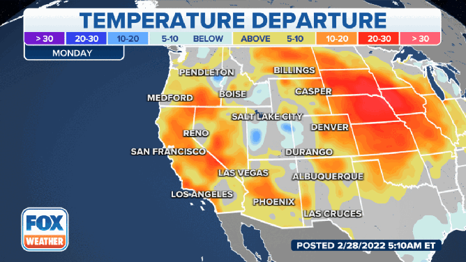
Temperatures will be above average in the western half of the country this week.
While the ridge of high pressure sits over the Southwest, it will allow for temperatures to stay above average for most of the region throughout the first half of the week.
Most of the warmest temperatures will be in the central U.S. on Monday, but that will expand to include more of the West as the week continues. Some areas could see temperatures between 20 and 30 degrees above average by Wednesday.