Powerful storm set to sweep across US bringing heavy rain, mountain snow, severe weather to millions
The storm will bring much-needed rain to parts of the Pacific Northwest and Midwest. However, more rain isn't needed in the Northeast, where the region has already seen weeks of relentless rainfall that has ruined weekend plans for millions since the beginning of the summer.
Coast-to-coast storm impacting 30 states into weekend
FOX Weather is tracking a storm plowing through the West Coast currently across the country and delivering another soggy weekend to the Northeast. Meteorologists Marissa Torres and Abby Acone highlight the rain and snow across the Pacific Northwest and Rockies. Meteorologist highlights the heavy rain and severe storms threatening the center of the nation. And Torres wraps up the weekend with a storm dampening the Mid-Atlantic and Northeast states.
The FOX Forecast Center is tracking a powerful storm system sweeping across the U.S. this week that will bring threats of heavy rain, mountain snow, severe weather and a Northeast coastal storm to millions of Americans in more than 30 states from coast to coast.
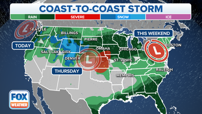
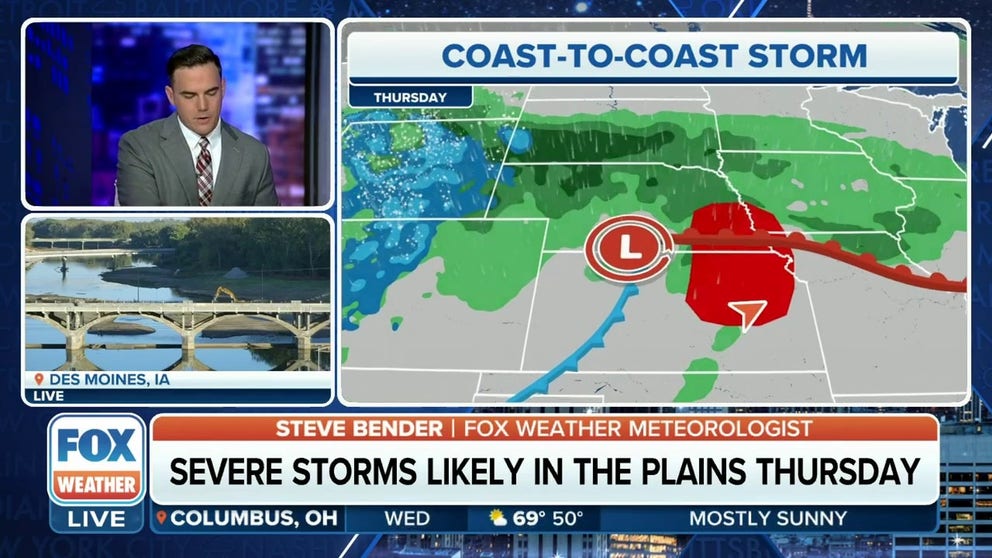
A coast-to-coast storm will be bringing heavy rain, snow and severe weather to millions of Americans this week.
(FOX Weather)
The Northwest is up first as the system sweeps in from the Pacific Ocean and brings rain, possible thunderstorms and mountain snow to the region through midweek.
The Plains and Midwest will feel the storm's effects toward the middle and end of the week, with flooding rainfall and severe weather being the main threats from the storm.
The Northeast and East Coast will be last to feel the storm’s wrath into the weekend, with a coastal storm developing and moving up the coast that could bring more heavy rain and gusty winds to the region.
Storm to impact Northwest with heavy rain

(FOX Weather)
The first round of much-needed rain began pushing into the Northwest early Monday morning, but the bulk of the precipitation will fall on Tuesday as the storm pushes ashore.
"The weather we’re going to feel across the Northwest is not strange," FOX Weather meteorologist Britta Merwin said. "This is what we expect this time of year in the Northwest. A little bit of a wind component and a rain component. It’s just kind of gross Northwest weather."
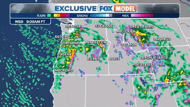
The FOX Model FutureTrack shows a storm clearing the Pacific coast late Wednesday into Thursday.
(FOX Weather)
Rainfall totals will get higher with elevation as it’s still too warm to support widespread snowfall in the mountains.
"This is a true Pacific front with a lot of moisture," Merwin continued. "It’s going to wring out in the foothills of the Cascades, the Olympic Mountains, the Coastal Range, so be prepared. It’s going to be several inches of rain."

(FOX Weather)
There will also be mountain snow, but it will be limited to the highest peaks of the Cascades and Rocky Mountains.
"Keep in mind, this is Pacific air," Merwin said. "It is mild. We don’t have a lot of cold air mixed in yet. So, we’re talking about maybe a spritz of snow in the highest peaks. You’re not going to drive and see it, so don’t worry about that."

(FOX Weather)
Still, some winter weather alerts have also been posted for several areas that are expected to see snow.
"The lower snow levels are going to be over the Rockies and the Wasatch Mountains," Merwin said. "And included in this, we have Winter Weather Advisories out there. Winter Weather Advisory for Yellowstone and Winter Storm Watches are posted for Wyoming. Those eventually will be Winter Storm Warnings."
Storm strengthens in the Plains, Midwest

FILE - Torrential rains delayed races at the NASCAR street course in Chicago, Illinois, on Sunday, July 2, 2023.
(Jim Vondruska/Bloomberg / Getty Images)
The FOX Forecast Center says the main energy from the coast-to-coast storm will move into the Plains and Midwest by midweek.
That will support the development of a surface low-pressure system, with widespread rain and gusty winds being the storm's main impacts. However, severe weather is also possible as the storm system moves across the region.

The severe thunderstorm, large hail and damaging wind threat on Wednesday, October 11, 2023.
(FOX Weather)
Severe thunderstorms are possible Wednesday across portions of southeastern Nebraska, northeastern Kansas, southwestern Iowa and northwestern Missouri.
Currently, the risk is at a level 1 out of 5 on NOAA's Storm Prediction Center's (SPC) thunderstorm risk scale.
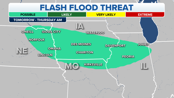
The flash flood threat on Wednesday, October 11, 2023.
(FOX Weather)
Flash flooding is also possible on Wednesday when the heavier rain sets up. The risk of flooding exists across eastern Nebraska through central and southern Iowa, northern Missouri and northwestern Illinois.
FLOOD WATCH, WARNING AND EMERGENCY: HERE ARE THE DIFFERENCES THAT COULD SAVE YOUR LIFE
(FOX Weather)
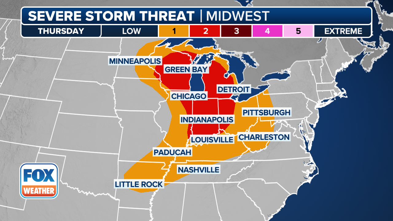
The severe weather risk will grow on Thursday, with areas of southeastern Nebraska and northeastern Kansas under a level 2 out of 5 on the SPC’s thunderstorm risk scale. Portions of southwestern Iowa and northwestern Missouri are also under a level 2 out of 5.

(FOX Weather)
The flash flood risk will be higher on Thursday, with the greatest chance along the South Dakota-Nebraska border, northwestern Iowa and extreme southwestern Minnesota.
The flash flood risk pushes off to the east by Friday, with the highest risk being seen in southeastern Minnesota, northeastern Iowa and around Lake Michigan in Wisconsin, northern Illinois, including Chicago, and western Michigan.
When all is said and done, a widespread area from the Plains to the Midwest can see 2 to 3 inches of rain, with areas of the South Dakota-Nebraska border, eastern Minnesota and southern Wisconsin seeing 3 to 5 inches of rain.

(FOX Weather)
Coastal storm could impact the Northeast this weekend
This weekend is expected to be another rainy washout for millions in the Northeast and New England.
The FOX Forecast Center says the coast-to-coast storm system will reach the Ohio Valley, Great Lakes region and the Northeast by Saturday.
NEW YORK, BOSTON HAVE HAD RAIN NEARLY EVERY WEEKEND THIS SUMMER. FALL IS OFF TO A SIMILAR START

NEW YORK, NEW YORK - SEPTEMBER 25: People walk over the Brooklyn Bridge during heavy rain and high winds as the remnants of Tropical Storm Ophelia continue to move through the area on September 25, 2023 in New York City. Much of the northeast U.S. saw a weekend of heavy rain and wind as the slow moving storm lingered from the Carolinas to New York City. (Photo by Spencer Platt/Getty Images)
(Getty Images)
There is also the possibility that the storm system transfers its energy to an offshore low, which may bring additional heavy rain and gusty winds to portions of the mid-Atlantic, Northeast and New England.
Temperatures at this time of year are generally too warm to support snow, which is why the FOX Forecast Center will be mostly tracking the possibility of flooding in the area.
PARTS OF NEW YORK SEE WETTEST DAY ON RECORD AS LIFE-THREATENING FLOODING SUBMERGES SUBWAYS, STREETS

(FOX Weather)
Several inches of rain could fall in the Northeast and New England by the time the system moves out of the region, with the highest totals between 2 and 3 inches falling along the Interstate 95 corridor from around the Philadelphia area through New York City and into Providence in Rhode Island and Boston. Locally higher amounts of 3 to 5 inches are also possible in some areas.
It would be the 14th weekend with rain in the Northeast since the start of June.
Regardless of how it develops, the system is expected to move out of the area by Monday, according to the FOX Forecast Center.