Bryan Norcross: Tropical Storm Franklin moves across Dominican Republic dumping rain on the mountainous island
On Tuesday, Franklin’s center of circulation was so disheveled, that it was hard to determine whether the system actually met the definition of a tropical storm. It is carrying a lot of tropical moisture, however, which it will drag over the mountains.

FOX Weather is your Hurricane HQ, streaming free 24/7.
(FOX Weather / FOX Weather)
Updated Wednesday 9 a.m. ET.
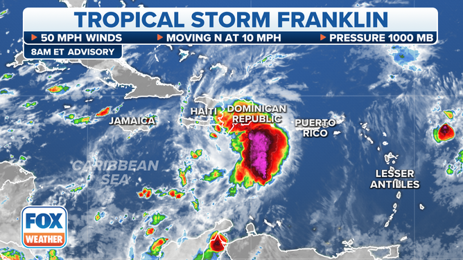
Tropical Storm Franklin got on its horse overnight and is crossing the island of Hispaniola near the border between the Dominican Republic and Haiti. The winds aren’t very high, but dangerous conditions will exist near the mountains due to the interaction of the tropical moisture and the high elevations.
Yesterday, Franklin’s center of circulation was so disheveled, that it was hard to determine whether the system actually met the definition of a tropical storm. It is carrying a lot of tropical moisture, however, which it will drag over the mountains.
The latest on Tropical Storm Franklin.
(FOX Weather)
The forecast is for up to 15 inches of rain in some spots in the Dominican Republic, with locally perhaps 4 inches in Puerto Rico on the fringe of the storm.
Assuming Franklin survives the trip across the storm-shredding mountains of Hispaniola, the atmospheric pattern should become more conducive for strengthening over the open Atlantic north of the Caribbean islands. The National Hurricane Center is forecasting the system so drift in a zigzag path for a few days with no impact on land.
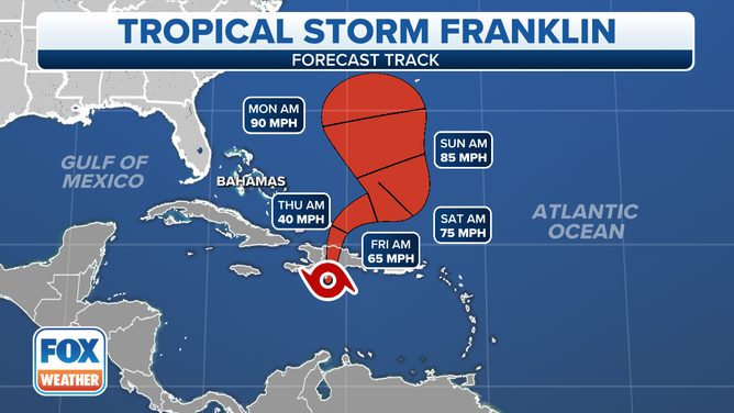
The forecast track of Tropical Storm Franklin.
(FOX Weather)
The long-range computer forecast show Franklin moving north. On the current schedule, it will be in the vicinity of Bermuda at the beginning of next week – possibly as a hurricane. Everyone there should stay informed.
What’s left of Tropical Storm Harold is just an area of rain over west Texas. It’s heading into New Mexico and Arizona.
An overview of the tropical Atlantic Ocean.
(FOX Weather)
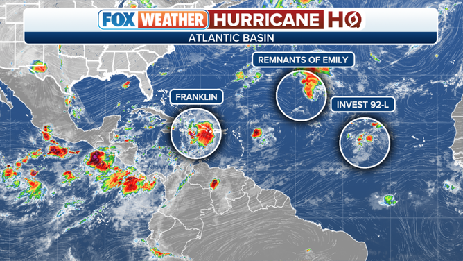
In the East Atlantic, the remnants of Tropical Storm Emily are trying to stage a comeback. The National Hurricane Center is giving the disturbance a high chance of redeveloping into a tropical depression or back into a tropical storm. It would keep the name Emily since there has been a trackable disturbance all along.
The other disturbance in the Atlantic, officially called Invest #92L still has a slight chance of developing, but its window is closing.
The only threat for now appears to be potential-Hurricane Franklin.