Bryan Norcross: Possible tropical storm for Texas while Franklin heads toward the northern Caribbean islands
Hilary's moisture will pull out of Southern California today, but lots of effects remain from California to the Northern Rockies.

FOX Weather is your Hurricane HQ, streaming free 24/7.
(FOX Weather / FOX Weather)
Updated at 9 a.m. on Monday
The tropical disturbance in the Gulf of Mexico is organizing as it heads for the Texas coast. Tropical Storm Franklin is going to impact Haiti, the Dominican Republic, Puerto Rico, and the surrounding islands. Now over Nevada, what was left of Hilary's circulation has dissipated. Hilary's moisture will pull out of Southern California today, but lots of effects remain from California to the Northern Rockies.
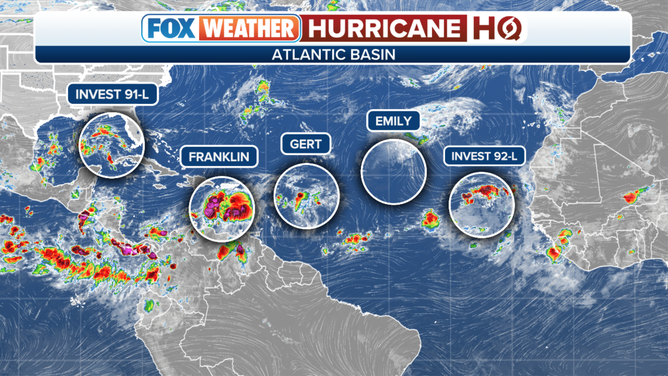
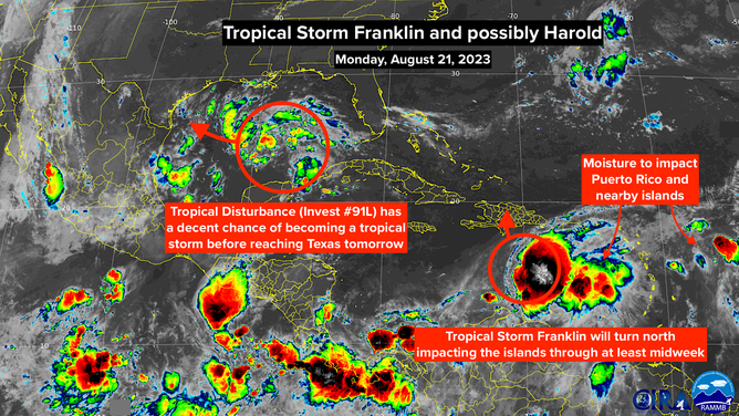
The tropical disturbance in the Gulf – officially tagged Invest #91L – formed out of the disturbance that passed over South Florida over the weekend. It will zoom over the very warm Gulf of Mexico waters today, with the moisture arriving at the Texas coast tonight. There is a good chance it could become a Tropical Storm Harold before the center arrives tomorrow, but it does not appear there is time for it to get exceptionally strong.
(FOX Weather)
Expect especially gusty winds where the winds blow onshore north of where the center of circulation makes landfall. Tropical Storm Watches and/or Warnings will likely be issued for part of the Texas coast today. Stay aware of the latest forecasts along the coast.
On the good side, the system will deliver beneficial rain for the south and south-central Texas coast and the drought-stricken regions inland, including San Antonio. It appears that Austin and Houston will be on the northern fringe of the system. On the current schedule, the system will make landfall tomorrow.
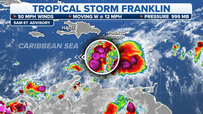
In the Caribbean, Tropical Storm Franklin formed from the disturbance that crossed the southeastern Caribbean islands on Saturday. A strong dip in the jet stream off the East Coast of the U.S. plus a low-pressure system over the Bahamas will pull Franklin more-or-less due north along with a ton of tropical moisture.
The latest on Tropical Storm Franklin.
Franklin is forecast to strengthen to just under hurricane strength by the time its center of circulation reaches the vicinity of the Dominican Republic and Haiti late tomorrow or early Wednesday. But the moisture will impact both countries plus Puerto Rico before that.
With the assumption that Franklin won't be too disrupted by the mountains of the Dominican Republic and Haiti, it is forecast to strengthen into a hurricane well north of the islands. The long-term steering currents could be complex. It could track in the direction of Bermuda in several days, but it's too soon to know for sure.
Small and fleeting Tropical Storm Gert formed east of the northeastern Caribbean islands over the weekend. It's dying out, but the leftovers of that system might add to Franklin's moisture over the northeast Caribbean.
Strong winds will impact the affected islands, but the biggest threat from Franklin appears to be the potential for flash flooding from the extended double-barreled shot of tropical moisture lasting at least until midweek. Stay informed over the next few days in Haiti, the DR, and Puerto Rico.
Information on Tropical Storm Franklin and possibly Tropical Storm Harold.
(NOAA / NOAA)
In the far eastern Atlantic, Tropical Storm Emily and an organizing Tropical Disturbance – officially Invest #92L – are forecast to move into the open ocean and die out.
It's time to pay attention to the tropics. The weather pattern is shifting, which could provide a path for systems to more easily turn to the north. It's that time of year.
The system that was Hurricane Hilary is now just a very long smear of tropical moisture that extends from California to the Northern Plains. The weather will dramatically improve in Southern California today as what's left of the Hilary pulls away. Some moisture will linger, however, which could cause thunderstorms to develop over the mountains adding to the rain totals.
Everybody in the band of rain from California north through Nevada, Oregon, Idaho, Montana, and North Dakota should stay aware of local alerts for flooding.