Bryan Norcross: Welcome to hurricane season 2025
An important takeaway from this early-season lull is that it doesn't mean anything about what will happen in the heart of the hurricane season.
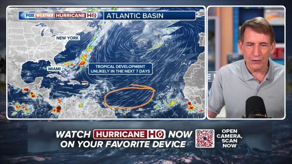
'Nothing going on' to start first day of Atlantic hurricane season
On the first day of hurricane season 2025, FOX Weather Hurricane Specialist Bryan Norcross has good news. There is nothing forecast to develop this week across the Atlantic. Listen to his analysis of the conditions currently keeping things tame – for now.
Welcome to hurricane season 2025.
There are no signs of tropical development across the Atlantic, Caribbean and Gulf for the next week, at least. Even the long-range forecasts show low odds of something developing in the western Caribbean or southwestern Gulf, but that possibility is well into the very slight chance category.
On social media, you might see posts of a storm the American GFS computer model wants to spin up in the Caribbean or Gulf, but 1) this is a known bias of the GFS at this time of year, and 2) none of the other models, including the latest AI models, show any significant signal for development. So we’re ignoring the GFS at this point.
An important takeaway from this early-season lull, however, is that it doesn't mean anything about what will happen in the heart of the hurricane season. The water in the western Caribbean and the southern Gulf is plenty warm – significantly warmer than average. So if the weather pattern configures itself in a way that's conducive for development, we'll get a system. But right now, there's no sign of that happening.
Tropical Storm Alvin developed in the Eastern Pacific last week, of course. It spun up over the very warm pocket of water just offshore of southern Mexico. The Eastern Pacific hurricane season starts on May 15 because conditions there quite often become conducive for development earlier than in the Atlantic.
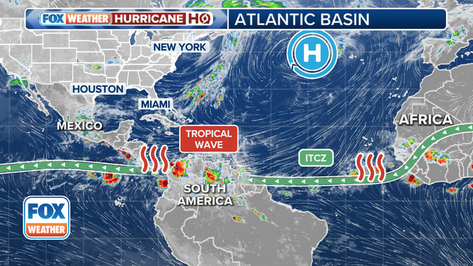
This satellite image shows the tropical Atlantic Basin on June 1, 2025.
(FOX Weather)
Alvin is now history. There is a decent chance that another system might form offshore of Mexico in the next several days. If it becomes a tropical storm, it will be named Barbara.
One of the most common mechanisms for developing an early-season system is a broad area of low pressure that tends to show up this time of year over Central America. Its technical name is the Central American Gyre, a gyre being a large rotating system. The northern edge of the broad low circulates across the western Caribbean and the southern Gulf, while the southern part of the system reaches into the Eastern Pacific.
If the weather pattern is conducive, a disturbance can emanate from the large parent gyre. So far, that mechanism looks most likely to generate systems in the Pacific – at least for a while.
The tropical Atlantic between the Caribbean and Africa is covered in Saharan dust, and the ocean water is quite cool. So there’s nothing to look at there for now.
Interestingly, Mother Nature has not produced strong storms anywhere in the Northern Hemisphere (north of the equator all around the world) so far this season. That's unusual. It's not clear what that means, or if it means anything for our hurricane season. It's just an interesting observation at this point.
The El Niño/La Niña phenomenon in the Pacific is in a neutral phase. This means that if things don't change, it will neither suppress nor hype Atlantic hurricane activity. How many storms develop and where they go are much more dependent on the daily or weekly weather pattern that develops over the Atlantic during the season than any long-range forcing from the Pacific. Some neutral years are quite busy, while others are unusually quiet.
NOAA scientists say there's about a 40% chance that La Niña will return before the end of the hurricane season, however. La Niñas tends to create an atmospheric pattern over the Atlantic that is more conducive to storm development. That means that the second half of the season might be busier than the first, but we'll see.
We've had enough hurricanes lately that nobody from Texas to Maine should dismiss the possibility of having to deal with a hurricane or its remnants. As we saw last year, folks who live well inland need to have a plan to take care of themselves if a dangerous or disruptive storm comes their way.
Early action is always better than scrambling at the last minute, so thinking and planning are more than appropriate right now. Talk to your friends and family. Now is the time to make a plan.
As I have said for years, living along the coast means living with hurricanes. There is nothing to do but to be prepared, and 2024 reminded us that "the coast" includes areas well away from the water.
Good luck this season. But a key lesson I've learned over many years is that people tend to make their own luck when it comes to hurricanes.