Bryan Norcross: US East Coast on alert for possible impacts from Hurricane Lee this week
The various computer forecasts have significant differences for the Wednesday starting point for Hurricane Lee's move north, so we have to be ready for a variety of outcomes late in the week.

FOX Weather is your Hurricane HQ, streaming free 24/7.
(FOX Weather / FOX Weather)
Updated at 9:00 AM
The critical day this week appears to be Wednesday to get a better handle on the magnitude of the impacts that Hurricane Lee will have on the East Coast – especially New England. There is high confidence that Lee will turn north midweek. What’s uncertain is where the storm will be located when a strong jet-stream dip comes along to scoop it up. The starting point of the move north will have a role in how close the future track is to the coastline.
Lee is crawling through the waters north of Puerto Rico and the surrounding islands. Tropical systems move slowly because the steering currents are weak. Without a defined river of air in the atmosphere to drive the storm’s motion, small and hard-to-detect influences can push the system one way or the other. In this case, the various computer forecasts have significant differences for the Wednesday starting point for the move north, so we have to be ready for a variety of outcomes late in the week.
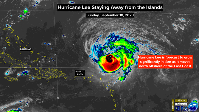
Satellite view of Hurricane Lee
(NOAA)
The threats include very high, powerful surf and dangerous currents along the entire East Coast, especially from North Carolina through the Northeast to Maine and Atlantic Canada. Direct impacts of strong, damaging winds in the Northeast and New England can’t entirely be ruled out, although a worst-case scenario is low odds. On the current schedule, Lee wouldn’t approach New England until next weekend, and many things can change between now and then.
The high certainty is that Hurricane Lee will grow in diameter and put a tremendous amount of energy in the Atlantic waters. Moving south to north from Florida to Maine, the ocean will become increasingly agitated and dangerous through the week. Powerful swells generating strong coastal currents and extra-large waves are likely. The surf will be very dangerous.
Lee has been moving through a stretch of somewhat hostile upper winds and dry air, disrupting the core and reducing the top winds in the circulation. Some of the computer forecast models show the environment ahead becoming more supportive of a stronger hurricane, and the National Hurricane Center forecasts intensification over the next couple of days. But the critical questions about the location and strength of the storm in about a week remain to be answered.
In the Northeast, New England, Bermuda, and Atlantic Canada plan to pay especially close attention to the forecasts this week.
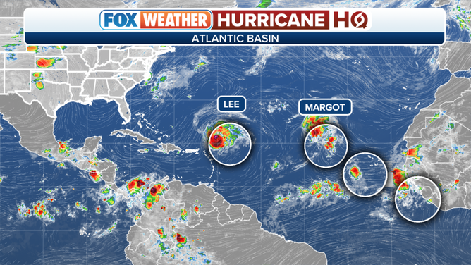
Tropical overview with Lee, Margot and two areas to watch.
(FOX Weather)
In the eastern Atlantic, Tropical Storm Margot is heading north and is forecast to reach hurricane strength before it dies out without impacting land.
Farther south, there are two tropical disturbances. The disturbance just moving off Africa looks likely to become the dominant system and absorb the small system just south of the Cabo Verde Islands. The combo system will have to be watched over the next week or so as it moves west, initially in the general direction of the Caribbean.