Bryan Norcross: Disturbance to watch is forming in the southern Gulf of Mexico
Regardless of any tropical development, a nasty and wet weather scenario is developing for the Gulf Coast. Some areas in east Texas and southern Louisiana afflicted by exceptional drought will hopefully receive beneficial rain, though too much at once can cause flooding, especially in urban areas.

FOX Weather is your Hurricane HQ, streaming free 24/7.
(FOX Weather)
Updated at 9:30 a.m. EDT on Monday
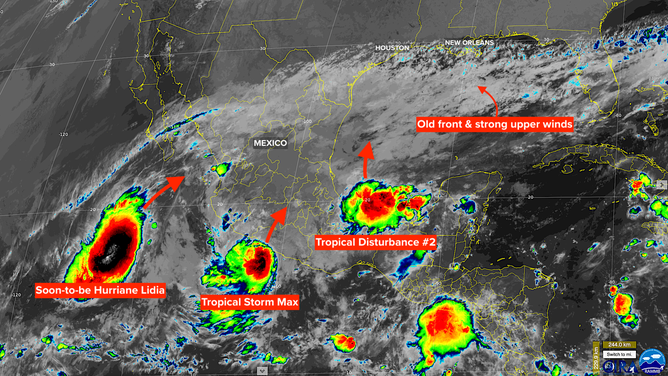
Tropical Disturbance 2 is a robust cluster of thunderstorms that popped up under a patch of supportive atmospheric conditions in the Bay of Campeche – the extreme southern Gulf of Mexico. This is a favored area for tropical systems to develop this time of year, aided by the curvature of the coast. Friction with the coastline helps get the air turning as it flows into the developing system. A weak area of low pressure is likely to form out of this scenario.
The high-pressure system from the Atlantic has nosed into the Gulf. The flow around the west side of that high is relatively strong from south to north. The fledgling low, with its mass of moisture, is likely to get caught in that flow and track north to off the Texas coast tomorrow and into the northern Gulf on Wednesday. That’s when things get more complicated.
A satellite image of the Gulf of Mexico and eastern Pacific Ocean on Monday, October 9, 2023.
(NOAA)
An old front draped across the northern Gulf will likely get involved. Plus, moisture and perhaps a bit of energy from Tropical Storm Max will join the party. Max is just about to make landfall on the Pacific coast of Mexico north of Acapulco.
Moisture from soon-to-be Hurricane Lidia, which will come ashore just north of Puerto Vallarta on Mexico’s Pacific coast, will stream toward the Gulf but seems likely to arrive too late to contribute to any potential development.
The bottom line on all this is a slight possibility of a tropical depression forming in the western Gulf over the next couple of days before the system gets completely involved with the front and upper winds become too hostile for further development.
Regardless of any tropical development, a nasty and wet weather scenario is developing for the Gulf Coast. Some areas in east Texas and southern Louisiana afflicted by exceptional drought will hopefully receive beneficial rain, though too much at once can cause flooding, especially in urban areas. Stay aware of local alerts.
It doesn’t appear there’s time for the system to become very strong before the environment becomes hostile, but we’ll watch to be sure. It doesn’t take much over the extremely warm Gulf waters for a storm to get going. Any possibility of development would be over by Thursday under the current forecast scenario.
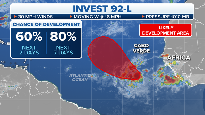
The outlook for Invest 92L in the eastern tropical Atlantic.
(FOX Weather)
On the far side of the Atlantic, Tropical Disturbance 1 is likely to develop into a tropical depression or tropical storm over the next few days. If winds reach 40 mph, it will be named Tropical Storm Sean – unless something surprising happens in the Gulf first. The system is forecast to turn north into the open ocean under marginal atmospheric conditions. It is not expected to be a threat to land.
This might be the last hurrah for the eastern Atlantic. Systems will still move off Africa, but increasingly hostile conditions are developing over the tropics, as expected in October. Unless something unusual happens, our focus will be in the Caribbean and the Gulf from now on.