Bryan Norcross: Caribbean tropical development is a bit more likely
The National Hurricane Center is giving the system a good chance of developing into at least a tropical depression late this week or over next weekend.

FOX Weather is your Hurricane HQ, streaming free 24/7.
(FOX Weather / FOX Weather)
Updated at 10:30 a.m. EST Monday
The persistent clusters of heavy thunderstorms over the extreme southern Caribbean Sea are related to a broad area of low pressure that straddles Panama and Costa Rica, extending into the Pacific.
Those thunderstorms are forecast to slowly develop into a more focused disturbance on the Caribbean side of Central America later this week.
The National Hurricane Center is giving the system a good chance of developing into at least a tropical depression late this week or over next weekend.
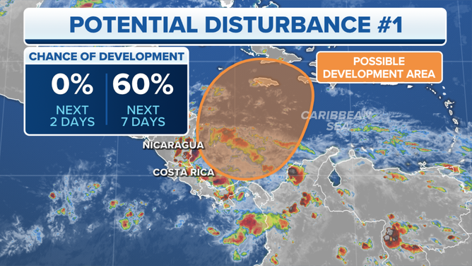
A system in the Caribbean has a medium chance of developing into at least a tropical storm over the next week.
(FOX Weather)
A system organizing in the Caribbean is related to the developing non-tropical low-pressure center over the Texas coast and its associated dip in the jet stream. These systems will spread east this week bringing heavy rain along the northern Gulf coast and to the Florida Panhandle.
Over the next few days, ahead of the Gulf system, the atmospheric pattern in the Caribbean will become more conducive for an organized disturbance to develop. By about Thursday, the jet stream dip will start to scoop that disturbance, whatever shape it’s in, toward the north.
It’s likely that significant tropical moisture will stream north over Jamaica, eastern Cuba, Haiti, the Dominican Republic, and the southeastern Bahamas. Whether there’s an organized tropical depression or perhaps Tropical Storm Vince in that moisture flow is an open question. The system, if it does develop, would move through the islands Friday or Saturday on the current schedule.
The forecast weather pattern is complex. The non-tropical Gulf low is forecast to move up the East Coast over the weekend and push its associated cold front toward the potential Caribbean system. Exactly how the two low-pressure systems, the dip in the jet stream, and the cold front interact is unknowable beyond the high likelihood that a very moist disturbance of some kind will be pulled north out of the Caribbean into the Atlantic.
For now, everybody in the north-central Caribbean and the southeastern Bahamas should be ready for an extended period of heavy rain and plan to stay informed about the latest developments later this week.