California’s crippling blizzard conditions continue Sunday before catching brief break from winter weather
The adverse weather has been fueled by a wide-reaching area of low pressure that has spanned much of the West Coast and fed a constant stream of snow that was expected to add up to 5 feet or more in the higher elevations and 2-5 feet in lower elevations where many residents live.
Blizzard continues to wallop California mountains with crippling conditions including feet of snow, 100-plus-mph wind gusts
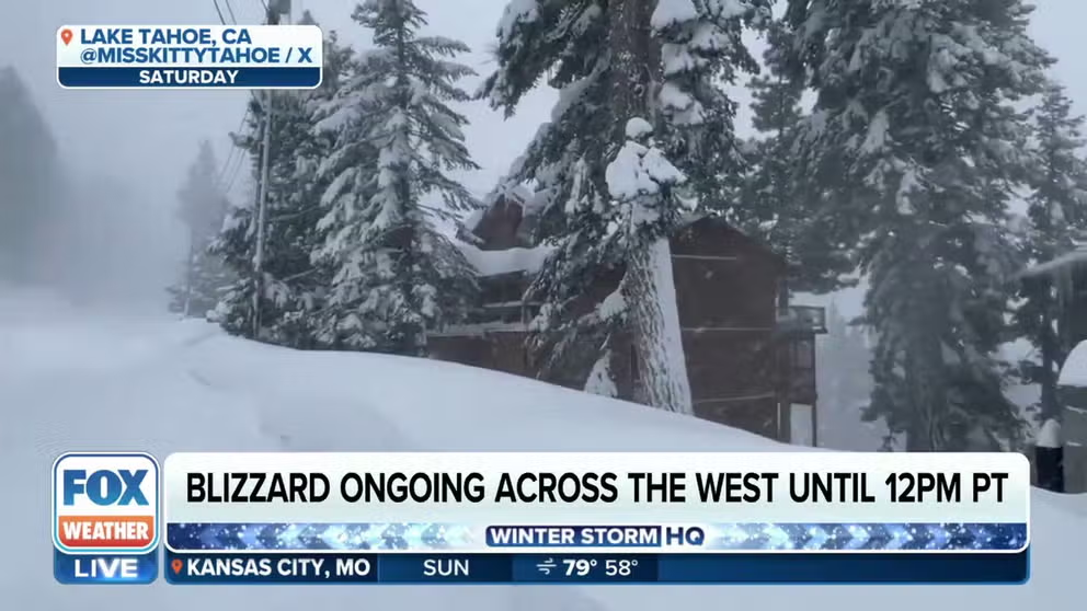
FOX Weather Correspondent Max Gorden was in South Lake Tahoe, California, on Sunday where a crippling blizzard has been blasting the Sierra Nevada with feet of mountain snow and high wind gusts leading to life-threatening conditions.
SOUTH LAKE TAHOE, Calif. – A dayslong powerful blizzard that has blasted California and the West with feet of mountain snow, wind gusts as high as 190 mph and even a rare tornado is continuing on Sunday before winter weather conditions subside a bit ahead of another round of snow and high wind gusts returning to the region at the start of the new workweek.
The adverse weather has been fueled by a wide-reaching area of low pressure that has spanned much of the West Coast and fed a constant stream of snow that was expected to add up to 5 feet or more in the higher elevations and 2–5 feet in lower elevations where many residents live.

(FOX Weather)
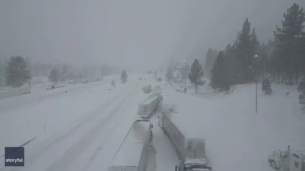
Several highways and mountain passes were closed due to the storm, including the busy Interstate 80 that links San Francisco to the Lake Tahoe region and Reno in Nevada via the Sierra Nevada mountain range. CalTrans crews shut down a 50-mile stretch of the roadway Friday evening from Drum Forebay to the California-Nevada state line after multiple spinouts were reported amid blizzard conditions.
Watch: Blizzard conditions keep I-80 closed in California
The California Highway Patrol shared video of whiteout conditions on Interstate 80 as a powerful blizzard blasted the region. I-80 remains closed from Colfax, California to the Nevada state line.
The closure was extended farther west to Colfax, California, and there's no estimated time for the interstate to reopen.
HOW TO DRIVE IN ICY CONDITIONS
Watch: Vehicles stuck on I-80 during epic blizzard in California
Video recorded in California shows a line of vehicles trapped on a snow Interstate 80 during a blizzard that brought several feet of snow to the Sierra Nevada mountains.
"(Friday) night we had a mass amount of vehicles stuck over Donner Summit and it took several hours for emergency personnel and tow trucks to reach motorists," officials with the California Highway Patrol posted on X. "At one point, emergency personnel and tow trucks had a difficult time getting to motorists due to blizzard conditions."
Troopers worked to help clear the road of abandoned vehicles left on the freeway after drivers were taken to a safe location, reiterating there is no estimate of when I-80 will reopen.
TRAVELING THIS WINTER? HERE'S WHAT TO KEEP IN YOUR CAR IN CASE YOU GET STUCK
Blizzard Warnings continue for parts of the Sierra Nevada, including the popular Lake Tahoe area, and are expected to last through Monday morning. A potentially deadly combination of extreme snowfall rates and hurricane-force wind gusts will continue, with whiteout conditions and rapidly accumulating and drifting snowfall.
Lake Tahoe's Palisades Ski Resort at 8,700 feet has recorded multiple wind gusts over 150 mph since Friday, including one measurement of a gust clocked at 190 mph Friday night, while a gust measured 84 mph closer to town.

(FOX Weather)
Even more dangerous, forecasters now warn of a chance of thunderstorms that could bring incredible snowfall rates of 4–6 inches per hour.
"Storms of this magnitude are rare and capable of closing major roads and damaging power infrastructure for extended periods of time," the NWS warned. "Make sure you have food, water, and a secondary heat source for more than several days in your home in case of extended power outages."
YOU WERE JUST INVOLVED IN A WEATHER-RELATED CRASH - NOW WHAT?
![Sierra Nevada Blizzard]() Image 1 of 16
Image 1 of 16TRUCKEE, CALIFORNIA - MARCH 01: Workers clear train tracks as snow falls north of Lake Tahoe in the Sierra Nevada mountains during a powerful winter storm on March 01, 2024 in Truckee, California. Blizzard warnings have been issued with snowfall of up to 12 feet and wind gusts over 100 mph expected in some higher elevation locations. (Photo by Mario Tama/Getty Images) (Mario Tama)
![Sierra Nevada Blizzard]() Image 2 of 16
Image 2 of 16TRUCKEE, CALIFORNIA - MARCH 01: Vehicles drive as snow falls north of Lake Tahoe in the Sierra Nevada mountains during a powerful winter storm on March 01, 2024 in Truckee, California. Blizzard warnings have been issued with snowfall of up to 12 feet and wind gusts over 100 mph expected in some higher elevation locations. (Photo by Mario Tama/Getty Images) (Mario Tama)
![California Blizzard CHP patrol car]() Image 3 of 16
Image 3 of 16A California Highway Patrol car drives in heavy snow near Lake Tahoe on March 2, 2024 (California Highway Patrol)
![Sierra Nevada Blizzard]() Image 4 of 16
Image 4 of 16TRUCKEE, CALIFORNIA - FEBRUARY 29: A snow plow drives along Interstate 80 eastbound in Truckee, Calif., on Friday, March 1, 2024. (Jane Tyska/Digital First Media/East Bay Times via Getty Images) (Jane Tyska/Digital First Media/East Bay Times)
![Sierra Nevada Blizzard]() Image 5 of 16
Image 5 of 16CALIFORNIA, USA - MARCH 1: Men remove snow around their vehicles as snow blanketed Emerald Bay Road in Lake Tahoe, California, United States on March 1, 2024 as blizzard warning issued for California's Sierra Nevada. (Photo by Tayfun Coskun/Anadolu via Getty Images) (Tayfun Coskun/Anadolu)
![Sierra Nevada Blizzard]() Image 6 of 16
Image 6 of 16TRUCKEE, CALIFORNIA - MARCH 01: A train worker climbs aboard as snow falls north of Lake Tahoe in the Sierra Nevada mountains during a powerful winter storm on March 01, 2024 in Truckee, California. Blizzard warnings have been issued with snowfall of up to 12 feet and wind gusts over 100 mph expected in some higher elevation locations. (Photo by Mario Tama/Getty Images) (Mario Tama)
![Sierra Nevada Blizzard]() Image 7 of 16
Image 7 of 16TRUCKEE, CALIFORNIA - FEBRUARY 29: Snow accumulates on bicycles at a condominium complex at the SpringHill Suites by Marriott Truckee hotel in Truckee, Calif., on Friday, March 1, 2024. (Jane Tyska/Digital First Media/East Bay Times via Getty Images) (Jane Tyska/Digital First Media/East Bay Times)
![Sierra Nevada Blizzard]() Image 8 of 16
Image 8 of 16CALIFORNIA, USA - MARCH 1: A view of snow blanketed houses along Donner Lake in Truckee, California, United States on March 1, 2024 as blizzard warning issued for California's Sierra Nevada. (Photo by Tayfun Coskun/Anadolu via Getty Images) (Tayfun Coskun/Anadolu)
![Blizzard warning issued for California's Sierra Nevada]() Image 9 of 16
Image 9 of 16CALIFORNIA, USA - MARCH 1: A vehicle collided with a snowplow as snow blanketed roads in South Lake Tahoe, California, United States on March 1, 2024 as blizzard warning issued for California's Sierra Nevada. (Tayfun Coskun/Anadolu)
![Sierra Nevada Blizzard]() Image 10 of 16
Image 10 of 16TRUCKEE, CALIFORNIA - FEBRUARY 29: A freight train rolls through a snowy Truckee, Calif., on Friday, March 1, 2024. (Jane Tyska/Digital First Media/East Bay Times via Getty Images) (Jane Tyska/Digital First Media/East Bay Times)
![Sierra Nevada Blizzard]() Image 11 of 16
Image 11 of 16TRUCKEE, CALIFORNIA - FEBRUARY 29: A Caltrans crew monitors the closed Interstate 80 westbound ramp in Truckee, Calif., on Friday, March 1, 2024. (Jane Tyska/Digital First Media/East Bay Times via Getty Images) (Jane Tyska/Digital First Media/East Bay Times)
![Sierra Nevada Blizzard]() Image 12 of 16
Image 12 of 16CALIFORNIA, USA - MARCH 1: A snowplow clear snow from roads in Lake Tahoe, California, United States on March 1, 2024 as blizzard warning issued for California's Sierra Nevada. (Photo by Tayfun Coskun/Anadolu via Getty Images) (Tayfun Coskun/Anadolu)
![Sierra Nevada Blizzard]() Image 13 of 16
Image 13 of 16TRUCKEE, CALIFORNIA - FEBRUARY 29: A sign at Northstar California Resort indicating that chains and four-wheel drive are required in Truckee, Calif., on Friday, March 1, 2024. (Jane Tyska/Digital First Media/East Bay Times via Getty Images) (Jane Tyska/Digital First Media/East Bay Times)
![Sierra Nevada Blizzard]() Image 14 of 16
Image 14 of 16CALIFORNIA, USA - MARCH 1: A snowplow clear snow from roads in Lake Tahoe, California, United States on March 1, 2024 as blizzard warning issued for California's Sierra Nevada. (Photo by Tayfun Coskun/Anadolu via Getty Images) (Tayfun Coskun/Anadolu)
![Sierra Nevada Blizzard]() Image 15 of 16
Image 15 of 16CALIFORNIA, USA - MARCH 1: A UPS vehicle is seen as snow blanketed roads in Lake Tahoe, California, United States on March 1, 2024 as blizzard warning issued for California's Sierra Nevada. (Photo by Tayfun Coskun/Anadolu via Getty Images) (Jane Tyska/Digital First Media/East Bay Times)
![Sierra Nevada Blizzard]() Image 16 of 16
Image 16 of 16CALIFORNIA, USA - MARCH 1: A couple walk as snow blanketed roads in Lake Tahoe, California, United States on March 1, 2024 as blizzard warning issued for California's Sierra Nevada. (Photo by Tayfun Coskun/Anadolu via Getty Images) (Tayfun Coskun/Anadolu)


Yosemite National Park was shut down Thursday night ahead of the storm, which was forecast to bring several feet of snow to the park. The park will remain closed through at least noon Sunday, and possibly longer, National Park Service officials said.
Elsewhere, Winter Storm Warnings are posted for the combination of snow and gusty winds across other parts of Northern California. In parts of western Nevada, including Reno, a Winter Weather Advisory is in effect until 10 a.m. PST on Sunday.
Tornado touches down in Central California valley
The bad weather wasn’t confined to the Sierra Nevada. A tornado touched down in the San Joaquin Valley on Friday evening, triggering a rare Tornado Warning for the region.
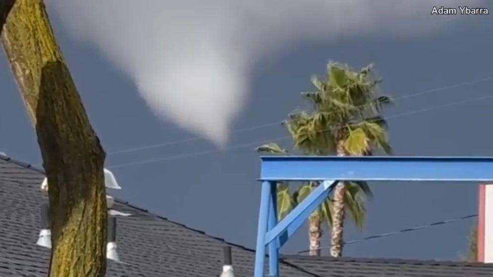
Caught on video: California tornado
A blizzard-producing storm system spawned at least one tornado in central California on Friday.
Despite the alerts, residents from all over the San Joaquin Valley took photos and videos of the funnel and the subsequent tornado as it worked northbound through properties used for residential and agricultural purposes.
Local authorities did not report any injuries associated with the event, and it was thought the twister was only briefly on the ground. An NWS storm survey team was scheduled to head to the area Saturday to assess the twister’s strength and any impacts.
In San Francisco, where wind gusts reached as high as 54 mph, four people were injured when a massive tree branch came crashing down on a car, according to the city’s fire department. All four were taken to a local hospital for treatment, but the extent of their injuries wasn’t given.
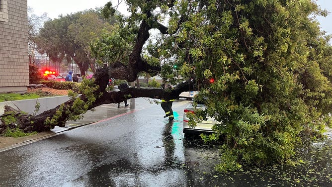
A large tree topples onto a car in San Francisco on Mar. 1, 2024.
(San Francisco Fire Department / FOX Weather)
Nevada faces hurricane-force wind gusts
The massive area of low pressure swirling across the West is also helping to produce damaging winds across Nevada that have caused power outages.
NV Energy, the state's largest utility provider, reported more than 25,000 outages on Saturday afternoon, which included parts of the famous Las Vegas Strip.
The company asked for customers' patience as some of the outages could have been extensive, especially in the mountainous regions. Outage numbers dropped significantly by Sunday, with PowerOutage.US reporting less than 1,000 outages.
Harry Reid International Airport recorded a wind gust of 68 mph, which made the day the windiest March date since 1985.
HOW TO SUCCESSFULLY DIG YOUR CAR OUT FROM THE SNOW, AFTER YOU FIND IT
(FOX Weather)
Outage numbers have also dropped in California, with PowerOutage.US reporting more than 19,000 on Sunday afternoon.
When will the snow end?
While the strong winds and heavy snow should begin to taper off later Sunday, snow remains in the forecast for the region well into the week ahead as the broad area of low pressure continues to send a stream of moisture and wind into the Sierra Nevada mountain range.
The National Weather Service said increasing precipitation chances, including additional heavy snowfall, is expected from the southern Cascades into the northern Sierra and potentially inland across the northern Great Basin.
"Timing and the location of the heaviest amounts remain uncertain at this time, but another influx of moisture from the Pacific is expected," the NWS said.
Drier weather promises to return later in the week, though the extended forecast hints at a return of storm activity the following week.
"We are hoping you are ready to be in this for the duration, because you will be either way," NWS forecasters in Reno, Nevada, said.