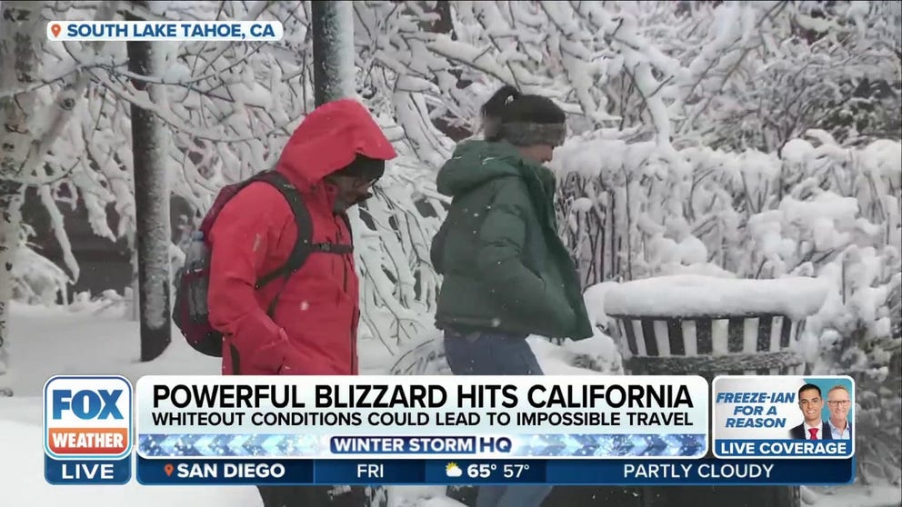
'Life-threatening' blizzard unfolding in California mountains with 10-plus feet of snow, 145-mph winds
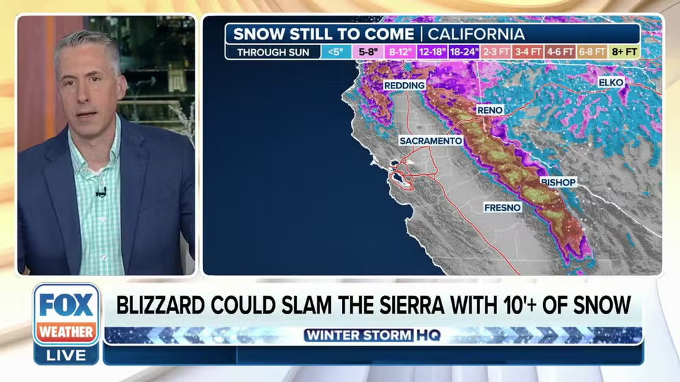
Blizzard Warnings cover the Lake Tahoe area through Sunday morning. As much as 3-6 feet of snow is expected around Lake Tahoe, with the worst conditions likely from late Friday into Saturday. Additional snowfall is likely thereafter.
Massive snowstorm set to dump 10-12 feet of snow in California's Sierra Nevada
Dangerous blizzard conditions are pummeling the Sierra Nevada through the weekend with ferocious wind gusts and snow totals expected to climb over 10 feet.
SOUTH LAKE TAHOE, Calif. – A crippling blizzard is pummeling the mountains of California and Nevada, creating life-threatening conditions along the Sierra Nevada and surrounding communities as incredible amounts of snow threaten to bury roads and neighborhoods.
"Snow amounts have increased, if that is even possible," bewildered forecasters at the National Weather Service office in Reno wrote in their forecast discussion. "Snow amounts will approach and even exceed 10 feet along the crest with multiple feet down into Sierra communities."
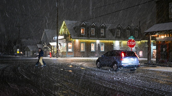
Whiteout conditions forced troopers to close Interstate 80 on Friday along the California-Nevada state line.

(FOX Weather)
"It's just all weekend," FOX Weather Meteorologist Britta Merwin said. "That's all you need to know. It is literally all weekend."
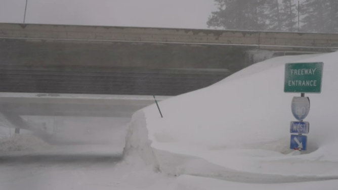
Blizzard Warnings have been issued through Sunday morning for the northern and central Sierra, including Lake Tahoe.
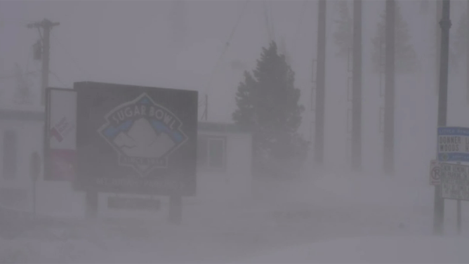
![Blizzard conditions hit Sierra Nevada]() Image 1 of 8
Image 1 of 8Heavy snows fall at Lake Tahoe's Sugar Bowl ski resort on Feb. 29, 2024. (Brandon Clement)
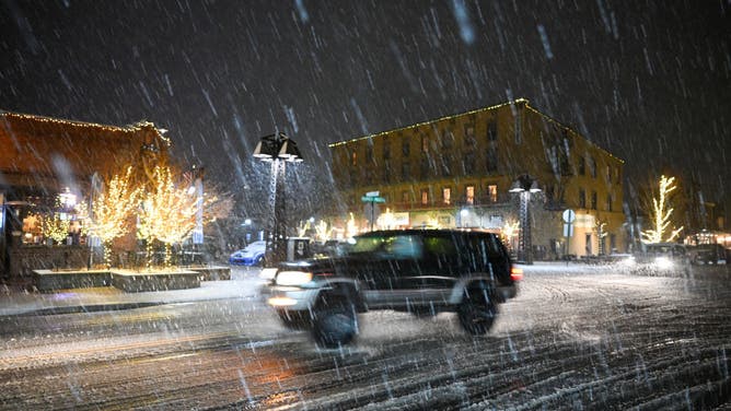
![Snow storm in California's Sierra Nevada]() Image 2 of 8
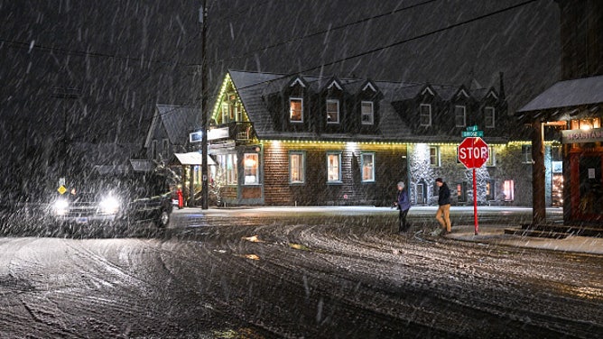
Image 2 of 8TRUCKEE, CALIFORNIA - FEBRUARY 29: A view of Historic Downtown during heavy snowfall in Truckee, California, United States on February 29, 2024 as winter storm in effect California's Sierra Nevada. (Tayfun Coskun/Anadolu)
![Snow storm in California's Sierra Nevada]() Image 3 of 8
Image 3 of 8TRUCKEE, CALIFORNIA - FEBRUARY 29: A snowplow clear snow from Highway 80 Eastbound during heavy snowfall in Truckee, California, United States on February 29, 2024 as winter storm in effect California's Sierra Nevada. (Photo by Tayfun Coskun/Anadolu via Getty Images) (Tayfun Coskun/Anadolu)
![Blizzard conditions hit Sierra Nevada]() Image 4 of 8
Image 4 of 8Heavy snows fall near Lake Tahoe's Sugar Bowl ski resort on Feb. 29, 2024. (Brandon Clement)
![Snow storm in California's Sierra Nevada]() Image 5 of 8
Image 5 of 8TRUCKEE, CALIFORNIA - FEBRUARY 29: A truck moves on Highway 80 Eastbound during heavy snowfall in Truckee, California, United States on February 29, 2024 as winter storm in effect California's Sierra Nevada. (Photo by Tayfun Coskun/Anadolu via Getty Images) (Tayfun Coskun/Anadolu)
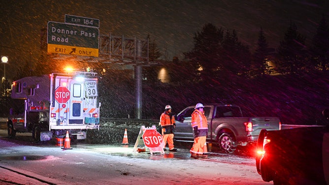
![Snow storm in California's Sierra Nevada]() Image 6 of 8
Image 6 of 8TRUCKEE, CALIFORNIA - FEBRUARY 29: A view of tire chain control point near Donner Pass Road during heavy snowfall in Truckee, California, United States on February 29, 2024 as winter storm in effect California's Sierra Nevada. (Photo by Tayfun Coskun/Anadolu via Getty Images) (Tayfun Coskun/Anadolu)
![Snow storm in California's Sierra Nevada]() Image 7 of 8
Image 7 of 8TRUCKEE, CALIFORNIA - FEBRUARY 29: A view of Historic Downtown during heavy snowfall in Truckee, California, United States on February 29, 2024 as winter storm in effect California's Sierra Nevada. (Photo by Tayfun Coskun/Anadolu via Getty Images) (Tayfun Coskun/Anadolu)
![Snow storm in California's Sierra Nevada]() Image 8 of 8
Image 8 of 8TRUCKEE, CALIFORNIA - FEBRUARY 29: A view of Historic Downtown during heavy snowfall in Truckee, California, United States on February 29, 2024 as winter storm in effect California's Sierra Nevada. (Photo by Tayfun Coskun/Anadolu via Getty Images) (Tayfun Coskun/Anadolu)
"Storms of this magnitude are rare and capable of closing major roads and damaging power infrastructure for extended periods of time," the NWS warned. "Make sure you have food, water, and a secondary heat source for more than several days in your home in case of extended power outages."
Yosemite National Park was shut down Thursday night ahead of the storm, which was forecast to bring several feet of snow to the park. The park was to remain closed through at least noon Sunday, and possibly longer. Park officials urged visitors to leave as soon as possible.
The culprit is a massive area of low pressure swirling in the northern Pacific Ocean, not only flooding the West Coast with cool air, but a steady stream of moisture.

(FOX Weather)
"It's really a perfect setup here," says FOX Weather Winter Storm Specialist Tom Niziol. "Precipitation is coming off the largest ocean in the world. It's an inexhaustible supply of moisture. And it is hitting the Sierra range broadside/perpendicular. That gives it the most amount of lift going over those mountains… It’s kind of like the perfect storm."
Whiteout conditions reported on I-80 near the NV-CA state line
California State Patrol shut down Interstate 80 near Nevada state line due to spin outs, high winds and low visibility.
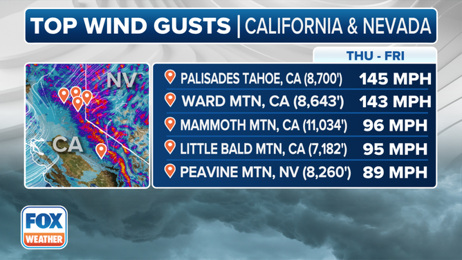
Gusts hit 145 mph along Sierra Nevada ridgetops
Aside from heavy snows, ferocious wind gusts will make for whiteout conditions. Gusts in the foothills will exceed 55 mph, while gusts in the higher elevations have well exceeded hurricane-force strength.
Already a wind gauge from Palisades Tahoe at 8,700 feet recorded a gust of 145 mph. The strong winds and heavy snow could cause extensive tree damage and extended power outages.
(FOX Weather)
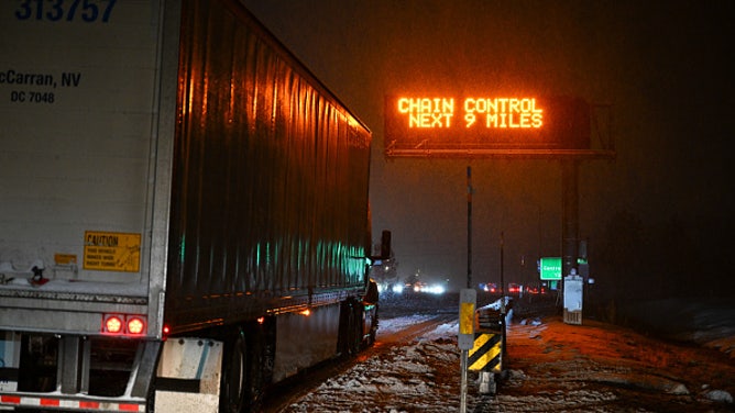
Chains are required on most of the major interstates and highways in the Sierra as heavy snow began to bury roadways.
"Your safe travel window is over in the Sierra," NWS Reno said late Thursday. "Best to hunker down where you are."
Strongest winter storm of year impacts California
Winds gusts of greater than 65 mph are possible as well as feet of snow in the mountain ranges.
The accidents started in the mountains before the snow had a chance to accumulate. A snowplow did double duty and stepped in to clear a wreck off the highway Thursday morning.

A snowplow had to clear a crash off the highway just as the snow started to fall.
(P Truckee / FOX Weather)
Elsewhere, Winter Storm Warnings are posted for the combination of snow and gusty winds across other parts of Northern California and western Nevada, including Reno, which itself could see up to a foot of snow. Carson City averages about 14 inches of snow a year and could get that in just this storm alone.
"Because the winds are so strong, rather than just hitting the windward or western side of the mountains, the snow is being carried across the entire mountain range," Niziol said. "So we're going to see heavy snowfall amounts even into a good part of Nevada."
TRAVELING THIS WINTER? HERE'S WHAT TO KEEP IN YOUR CAR IN CASE YOU GET STUCK

(FOX Weather)
Blizzard Warnings cover Lake Tahoe area
The Lake Tahoe area – a popular travel destination throughout the year, especially for those around the San Francisco Bay Area, Las Vegas and Reno, Nevada – is covered in Blizzard Warnings that remain in effect through Sunday at 10 a.m. PST.
As much as 3–6 feet of snow is expected around Lake Tahoe, with the worst conditions likely from late Friday into Saturday. Additional snowfall is likely after that. Mountains above 5,000 feet could see up to 10 feet of snow.
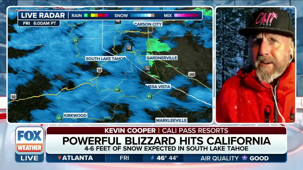
Sierra Nevada ski resorts hunker down ahead of epic snowstorm
Kevin Cooper with Cali Pass Resorts says he's never seen a forecast for 12 feet of snow before for their area.
"We’ve been saying it for the past couple days —we’ve run out of colors to tell you how much snow is going to fall," FOX Weather Meteorologist Bob Van Dillen said of the snow forecast maps.

(FOX Weather)
Already some of the ski resorts around Lake Tahoe have closed for the storm and those who venture up to the area could find themselves snowbound for an extended period.
"If you're going to be there in your hotel, you're not going to be leaving," Merwin said. "So just think about those things and be prepared for it."
It will still be a major deal at lower elevations as well, the FOX Forecast Center said. Lower-elevation snow is favored on Saturday at or below 2,000 feet, as a surge of colder air is expected to lower snow levels through the weekend.
When will the snow end?
While the strong winds and heavy snow should begin to taper off later Sunday, snow remains in the forecast for the region well into next week as the broad area of low pressure continues to send a stream of moisture and winds into the Sierra Nevada.
"We are hoping you are ready to be in this for the duration, because you will be either way," NWS Reno forecasters said.