Southeast weekend severe weather threat to mark end of relentless soggy stretch in South
NOAA's Storm Prediction Center said Saturday's severe weather threat will be focused across Alabama and Georgia.
Waves of heavy rain, storms continue Friday along Gulf Coast
Days of rain have left areas of the Deep South drenched and we're looking at even more rain Friday. Showers and thunderstorms will pop up again today from Louisiana to Mississippi to Alabama and Georgia.
MONTGOMERY, Ala. – The end of a multiday wet-weather event that drenched the South and Gulf Coast this week is near, but not before a round of severe weather slams the Southeast this weekend.
The FOX Forecast Center said a system rolling out of the southern Plains will trigger rain and thunderstorms in the Southeast on Saturday, delivering one final blow to a waterlogged region that’s trying to dry out.
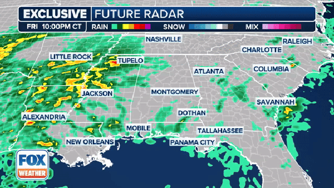
The exclusive FOX Model future radar.
(FOX Weather)
According to NOAA’s Storm Prediction Center (SPC), thunderstorms will likely be ongoing at the start of the weekend in portions of the Gulf Coast states.
As the heating of the day on Saturday continues, the SPC said surface temperatures will begin to rise, allowing for a pocket of instability to develop across portions of Alabama and western Georgia.
A strong jet stream associated with an upper-level disturbance will move across the Southeast on Saturday afternoon. Conditions in the atmosphere may be unstable enough to allow for a line of strong to severe thunderstorms to develop and roll across the region.
WHY YOU SHOULD RUSH INDOORS WHEN YOU SEE LIGHTNING OR HEAR THUNDER

(FOX Weather)
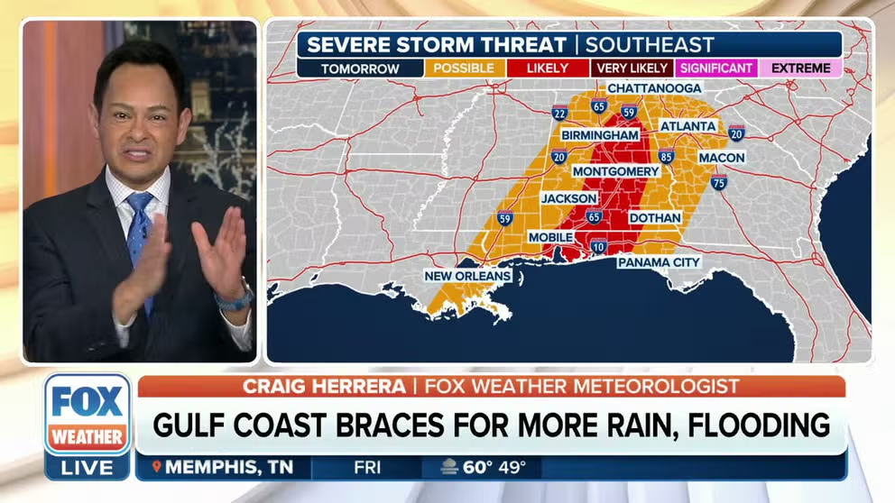
The SPC has placed portions of central and southern Alabama, as well as western Georgia, in a Level 2 out of 5 on its thunderstorm risk scale. That means people in cities such as Troy and Montgomery in Alabama should be weather-aware on Saturday.
And while the severe thunderstorm risk is lower, those in Mobile, Dothan and Birmingham in Alabama, as well as Columbus, Macon, Atlanta and Rome in Georgia, should also keep an eye to the sky during the day on Saturday.
As of Friday, the main threat associated with any of the severe weather that develops appears to be damaging wind gusts of 60 mph. Flash flooding is also possible due to heavy rain that could fall in a short period of time.
FLOOD WATCH, WARNING AND EMERGENCY: HERE ARE THE DIFFERENCES THAT COULD SAVE YOUR LIFE

(FOX Weather)
However, as with any thunderstorms, torrential rain and deadly lightning will also be a threat.
Computer forecast models also indicate that wind shear – the change in wind speed and direction with height – could also be present, which would allow for rotating thunderstorms to develop, potentially leading to the formation of a few tornadoes.
HERE'S WHERE TORNADOES ARE MOST LIKELY TO OCCUR IN EACH MONTH

7 ways to combat storm anxiety and stress
About 85% say they feel some sort of anxiety when storms approach or are forecast. Here are some ways to combat the stress:
The FOX Forecast Center said that the entire storm system will then advance northeastward on Sunday, producing a sloppy mess of winter weather in the mid-Atlantic, Northeast and New England.