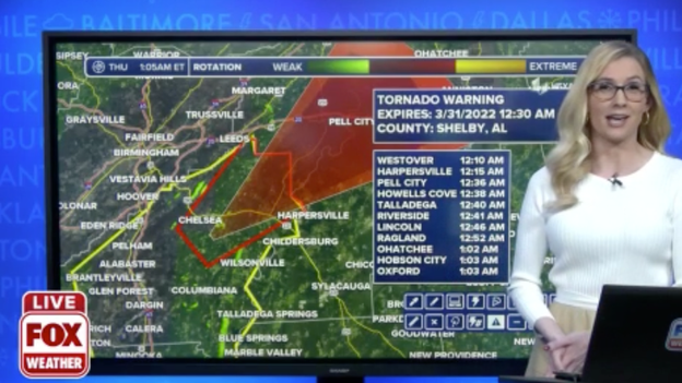
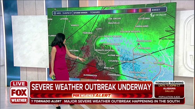
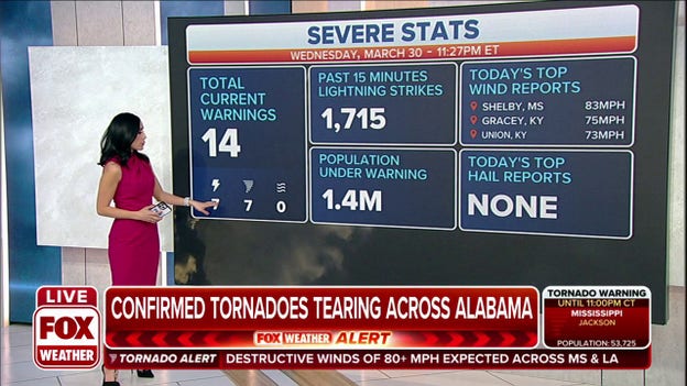
Tornado Warning issued for parts of Mobile, Alabama
A tornado-warned storm is moving through the northern parts of Mobile, Alabama. Mobile County is under a Tornado Warning until 11:15 p.m. CDT.
Andrew Wulfeck
Flooding impacts Sumrall, Mississippi
Mississippi resident Dale Holmes said the area around Sumrall High School received over an inch of rain in less than half an hour.
Andrew Wulfeck
Breaking News
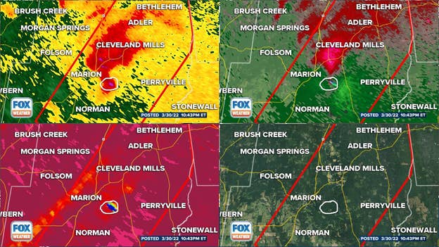
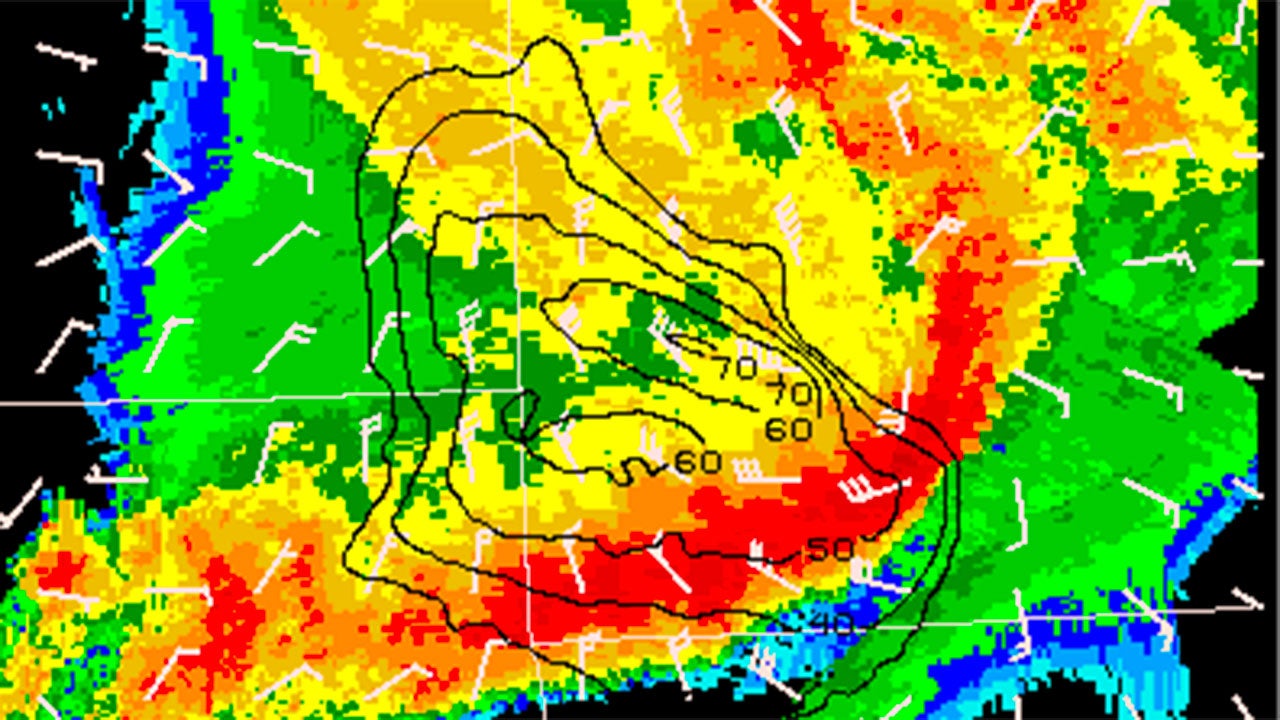
Particularly Dangerous Situation Tornado Warning in Bibb County, Alabama
Radar
A Particularly Dangerous Situation Tornado Warning has been issued for the storm in Bibb County, Alabama.
The tornado is moving northeast at 55 miles per hour.
Radar indicates that debris has been lofted to 13,000 feet in the air.
A PDS tornado warning means that NWS forecasters have high confidence that there is a strong and violent tornado causing destruction within the warned area.
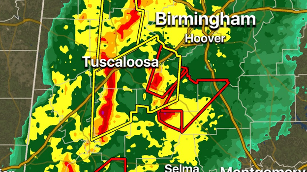
FOX Weather 3D Radar tracking tornado-warned storms in Alabama
FOX Weather 3D Radar
FOX Weather 3D Radar is tracking several tornado-warned storms in Alabama that are southwest of Birmingham. Meteorologists encourage residents in the city to monitor the severe storms in case they hold together.
Andrew Wulfeck
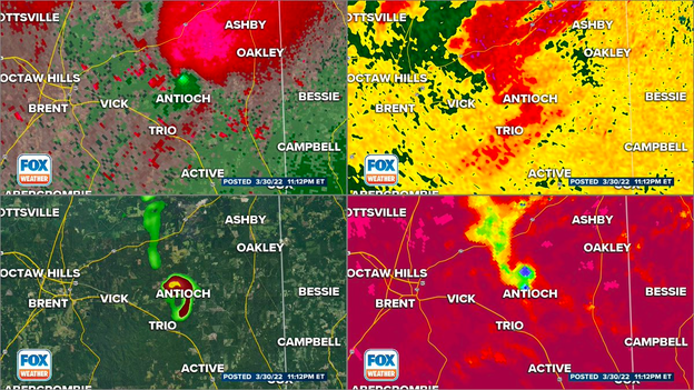
Radar detects significant rotation around Perry County, AL
Tornado-warned storm
A storm between Tuscaloosa and Montgomery is showing significant rotation on radar. Meteorologists say that is likely indicative of a tornado making its way through central Alabama. The storm is heading off to the northeast at more than 45 mph.
Andrew Wulfeck
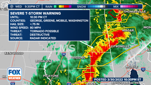
80 mile per hour destructive winds observed in Mississippi, Alabama
Destructive winds observed in MS, AL
The National Weather Service observed 80mph winds with the storms moving through Mississippi and Alabama.
These destructive winds will continue to move east throughout the evening.
A Tornado Warning has been issued for Kemper and Lauderdale counties in east-central Mississippi. Meteorologists said a confirmed large and extremely dangerous tornado was located over Toomsuba, moving northeast at 55 mph.
Andrew Wulfeck
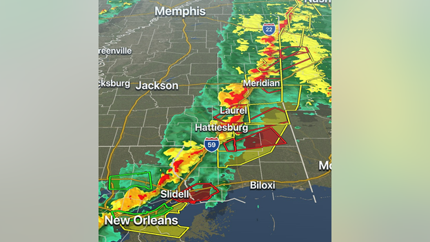
Several tornado-warned storms along MS-AL Line
FOX Weather 3D Radar
There are several storms along the Mississippi-Alabama line that are tornado-warned. Meteorologists expect areas along the Gulf Coast should remain active for strong to severe thunderstorms overnight.
Meteorologists are tracking a severe thunderstorm capable of producing a tornado around St. Tammany Parish in Louisiana. The Tornado Warning is in effect until 8 p.m. CDT and the storm cell is expected to move off to the north and east.
It was only 8 days ago that the New Orleans area was impacted by a tornado: Story
Andrew Wulfeck
Damaging wind gusts over 80 mph reported in storms
Some of Wednesday's severe storms produced damaging winds gusts over 80 mph.
Andrew Wulfeck
VIDEO FORECAST: Chance for severe storms continues overnight
Andrew Wulfeck
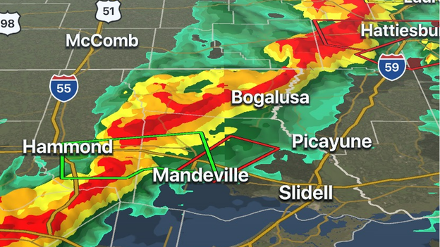
Tornado-warned storm moving towards Hattiesburg, MS
Tracking a severe thunderstorm
A storm with rotation is moving through southern Mississippi and could impact locations around Hattiesburg, Mississippi during the next 45 minutes.
A Tornado Warning is in effect for Marion, Forrest, and Lamar counties until 8:15 p.m. CDT.
Andrew Wulfeck
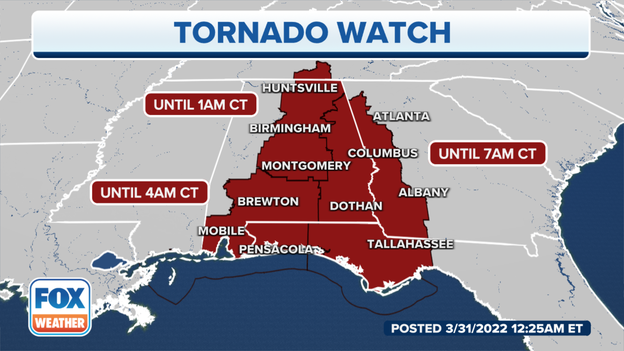
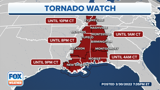
Tornado Watch issued for parts of MS, AL and FL into overnight hours
Tornado Watch
A Tornado Watch has been issued for parts of Mississippi, Alabama and Florida into the overnight hours. Meteorologists believe the threat of severe storms will continue well into the evening hours along the Gulf Coast.
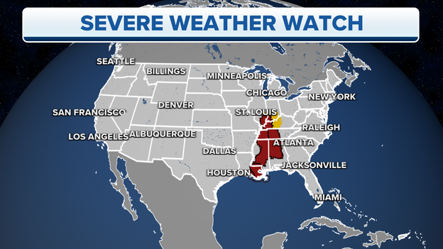
Severe Thunderstorm Watch issued for parts of Illinois, Indiana, Kentucky
Active severe weather watch boxes
A Severe Thunderstorm Watch has been issued for parts of Illinois, Indiana and Kentucky into the overnight hours because of the threat of damaging winds.
Meteorologists believe the tornado threat will diminish during the next several hours for areas on the northern side of the system.
The Severe Thunderstorm Watch goes until 1 a.m. CDT.
Andrew Wulfeck
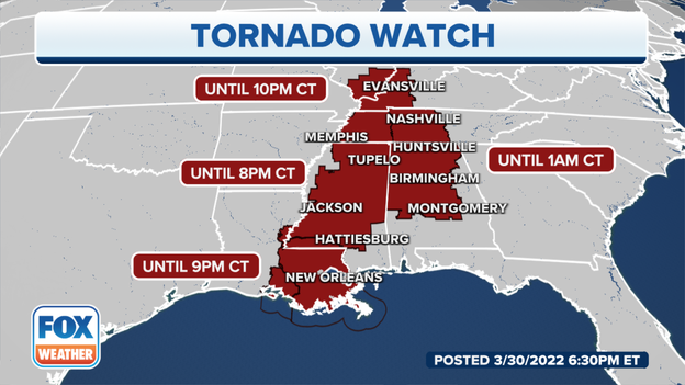
Tornado Watch issued for Alabama, Tennessee into overnight hours
Tornado Watch
As a line of severe thunderstorms continues to move eastward, it is expected to impact parts of central Tennessee and Alabama during the late evening hours.
A Tornado Watch has been issued until 1 a.m. CDT for the region.
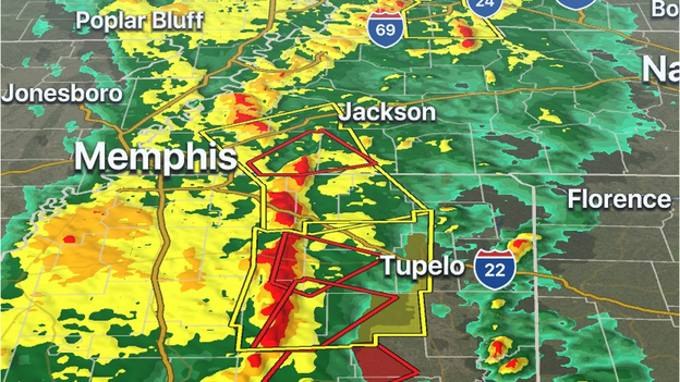
Line of tornado-warned storms moving through Mississippi
FOX Weather 3D Radar
Several counties in central and northern Mississippi are under a Tornado Warning because of the threat of rotating storms. Damage was recently reported in Jackson from these thunderstorms.
The storms are moving off to the east and northeast at more than 40 mph and will soon threaten areas along the Mississippi-Tennessee line.
Track the storms on FOX Weather 3D Radar: Click Here
Andrew Wulfeck
VIDEO: Trees down in Mississippi after severe storms move through
Andrew Wulfeck
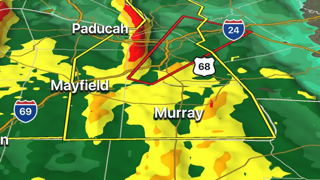
Tornado Warning issued east of Mayfield, Kentucky
FOX Weather 3D Radar
Meteorologists are tracking a severe thunderstorm capable of producing a tornado in western Kentucky. The National Weather Service has issued a Tornado Warning for Livingston, Marshall and Lyon counties until 5:30 p.m. CDT.
The storm is east of Mayfield, an area that was devastated by a massive tornado in December.
This storm will not impact the Mayfield area but heavy rain will push through the region during the evening hours.
Andrew Wulfeck
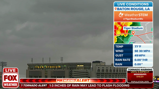
Strong storms moving into LSU & Baton Rouge
WeatherSTEM
A line of strong to severe thunderstorms continues its eastward trek and is moving into the LSU and Baton Rouge area. Heavy rainfall, cloud-to-ground lightning and gusty winds are all likely as the line of storms moves through.
The entire region is under a Tornado Watch because of the threat of rotating cells: Forecast
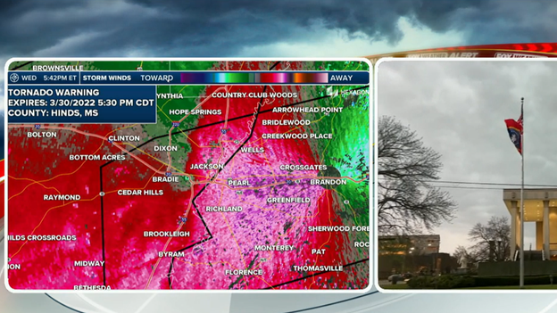
The National Weather Service says they received a report of a tornado on the southwest side of Jackson. The storm was moving eastward at around 45 mph. The entire area is under a Tornado Warning.
FOX Weather's Will Nunley is in the city tracking the storm and debris. Follow him on Twitter.
Andrew Wulfeck
VIDEO: Damage left behind in Arkansas after tornado
FOX Weather’s Robert Ray spoke with a family in Springdale, Arkansas who saw significant to homes.
Andrew Wulfeck
New Tornado Warning includes Jackson, Mississippi
The National Weather Service says this storm has a threat of a tornado and penny-sized hail.
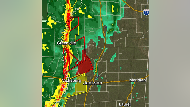
Tornado-warned storm moving through central Mississippi
FOX Weather Tornado Warning Coverage
A tornado-warned storm is moving north of Jackson, Mississippi, through the central part of the state. PowerOutage.US is reporting significant power outages in the western part of the state because of the storms.
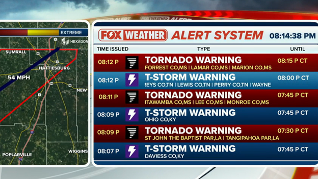
Watch the warnings come in live on FOX Weather's Alert System: Click Here
Andrew Wulfeck
Tornado Warning issued north of Memphis, TN
A severe thunderstorm with a possible tornado is expected to cross I-55 and the Mississippi River into West Tennessee over the next several minutes.
A Tornado Warning is in effect for Mississippi County, Arkansas and Lauderdale County, Tennessee until 4:30 p.m. CDT.
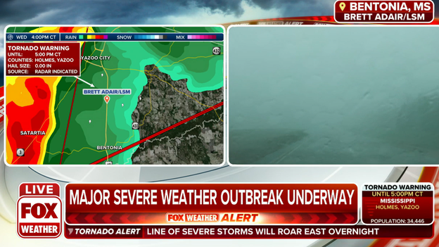
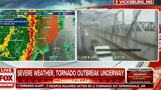
Tornado-warned storm moving towards Yazoo City, MS
Tornado Warning
Meteorologists are tracking a tornado-warned storm that is moving towards Yazoo City, Mississippi. The tornado is radar indicated and is not confirmed to be on the ground. The region is no stranger to tornadoes. Back in 2010 Yazoo City, MS was devastated by a massive wedge tornado.
Andrew Wulfeck
Planes working to avoid the dangerous weather
Pilots are working to avoid the worst of the storms moving through the South.
FlightAware reports there have been more than 2,500 flight delays today within, into or out of the U.S. but many of those are not being impacted by the severe storms.
Andrew Wulfeck
FOX Weather 3D Radar tracking several tornado-warned storms
FOX Weather 3D Radar
FOX Weather 3D Radar is tracking several tornado-warned storms moving into Mississippi from the west. The storms have a history of producing damage in Arkansas and Louisiana.
Several trees were damaged in the area around Jackson, MS. PowerOutage.US reported more than 17,000 outages in the state.
Andrew Wulfeck
FOX Weather reporter on scene of tornado damage in Arkansas
Andrew Wulfeck
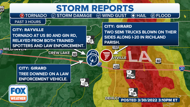
Tornado damage spotted in Northeast Louisiana
Authorities believe a suspected tornado moved over Interstate 20 around Girard, Louisiana, and flipped two semi-trucks. So far, there is no information on injuries.
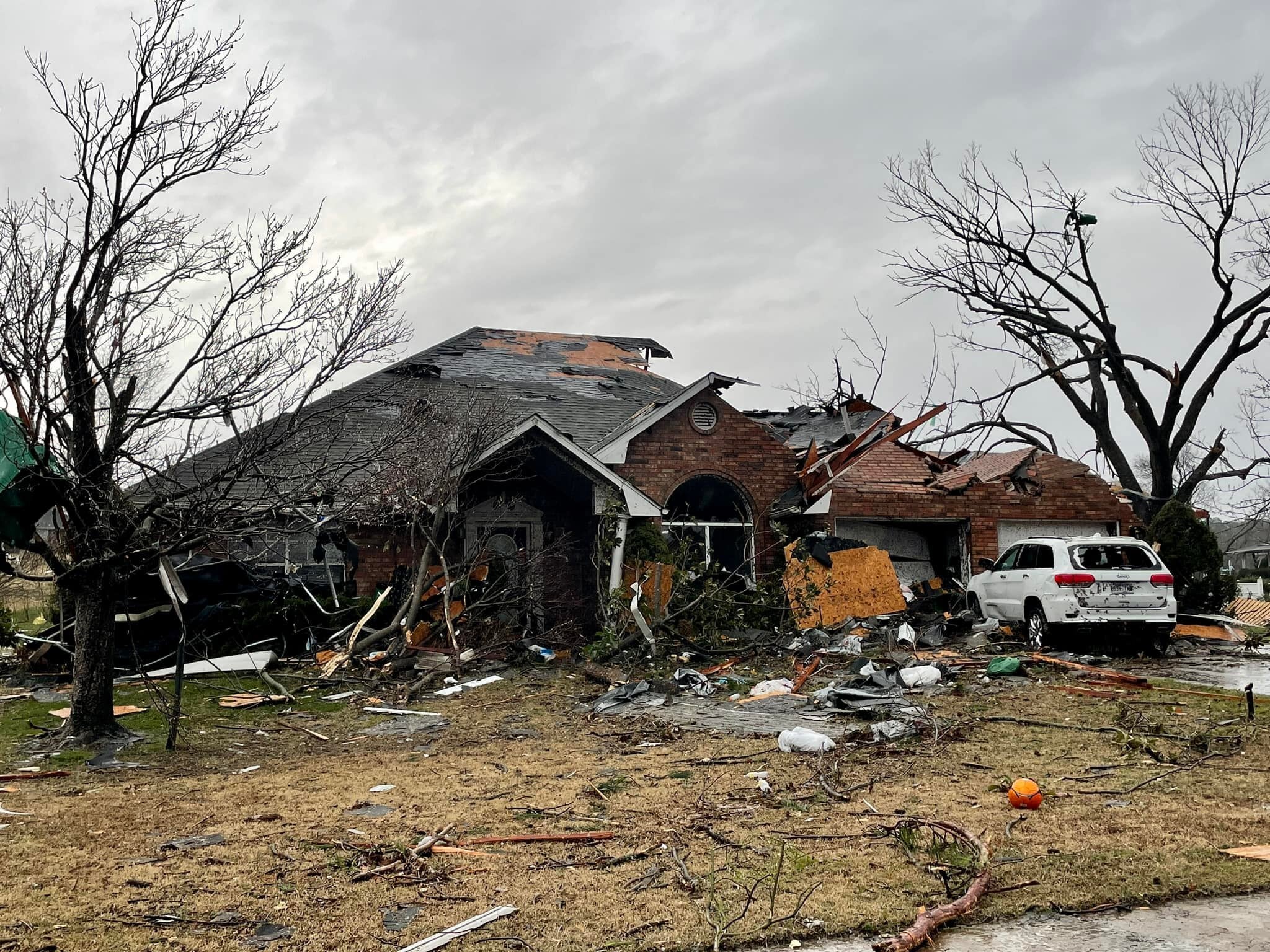
Meteorologists find EF-2 tornado damage in Northwest Arkansas
Tornado damage in Arkansas
National Weather Service meteorologists have given a preliminary rating of an EF-2 to the tornado that moved through Northwest Arkansas during the overnight hours. The storm's survey continues and could change based on what meteorologists find in the field.
Tornado Warning issued for Red River, Natchitoche, Winn parishes in Louisiana
The Tornado Warning is in effect until 12:30 p.m. Central and includes the communities of Clear Lake, Creston, Powhatan, Calvin, Goldonna and Black Lake.
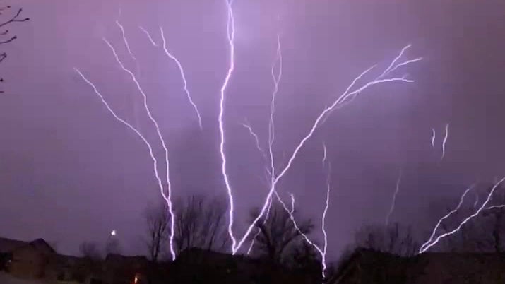
The bolt was a rare upward strike, where the bolt appears to begin at the ground and travels toward the cloud, as opposed to traditional lightning strikes that appear to go from cloud to ground.
Tornado Warning issued for De Soto, Red River, Natchitoches, Beinville parishes in Louisiana
The Tornado Warning is in effect until 12 p.m. Central and includes the communities of Naborton, Harmon, Coushatta, Hanna, Martin, Hall Summit, Castor, Ashland and Chestnut.
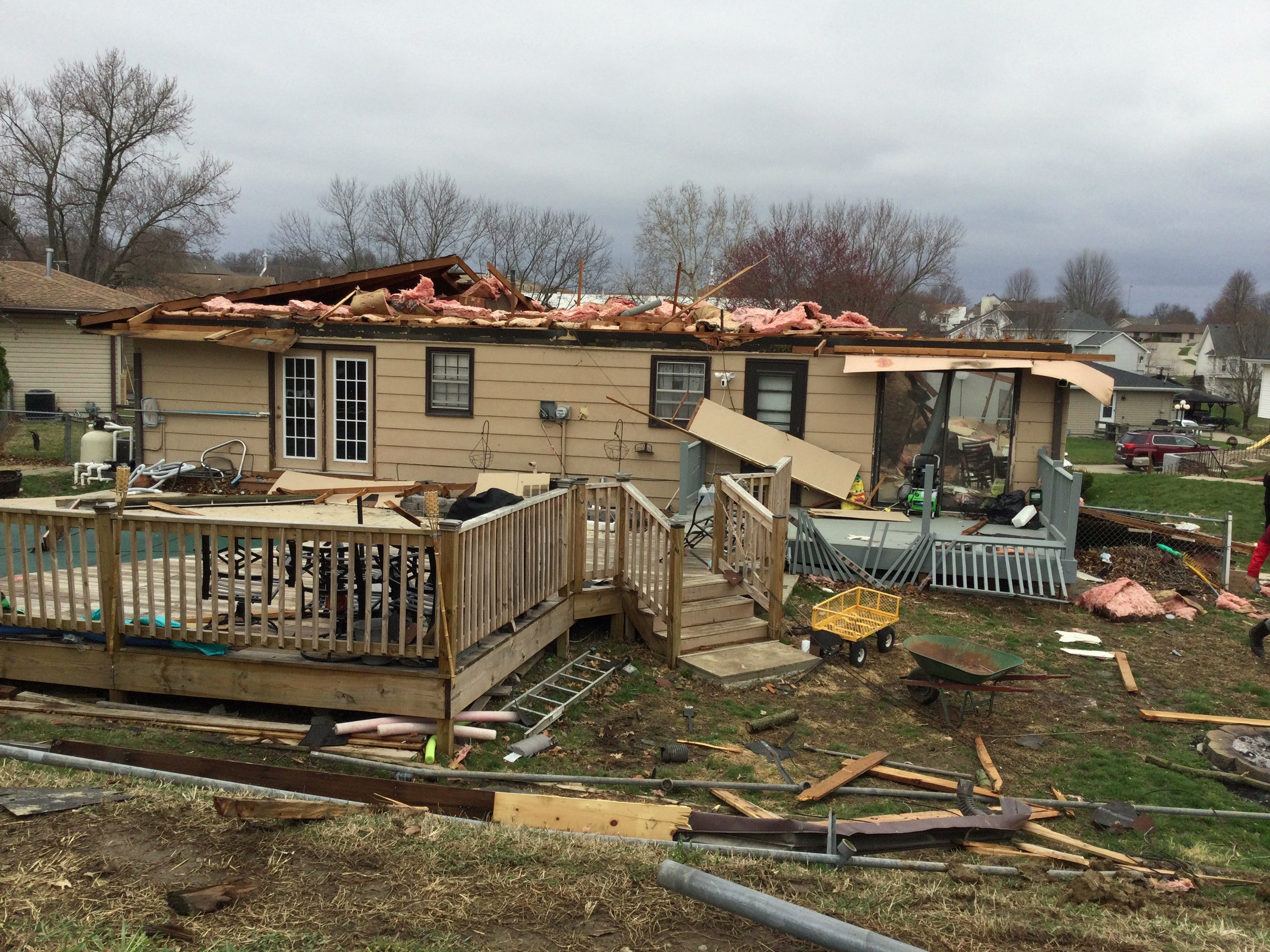
Homes, businesses destroyed after tornado-warned storms in Northwest Arkansas
The National Weather Service will determine if an early morning thunderstorm spawned a tornado in Northwest Arkansas early Wednesday morning. Click on the story below to see video and photos of the damage reports in the area.
7 people injured, 2 critical after possible tornado in Springdale, Arkansas
Springdale, Arkansas police Lt. Jeff Taylor says at least 7 people have been injured, including two people with critical injuries, after a possible tornado moved through the area early Wednesday morning.
For more information about the severe weather, click here.
An approaching storm can bring anxiety that can weigh heavily on a daily routine, and as the threat of severe and potentially destructive weather gets closer the stress levels can be overwhelming.
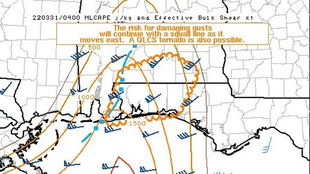
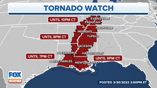
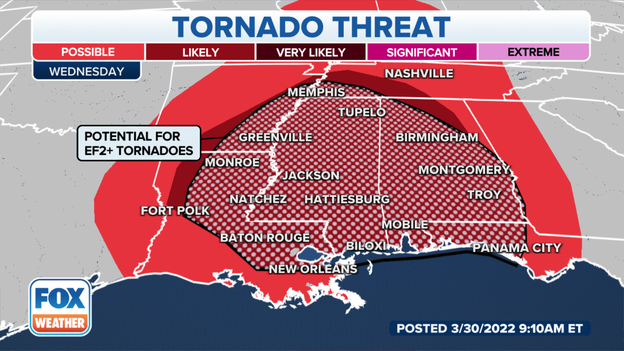
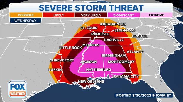
A severe thunderstorm outbreak is expected from the lower Mississippi Valley into parts of the Ohio and Tennessee valleys on Wednesday, spreading into portions of the central Gulf Coast later Wednesday into Wednesday night.
The severe weather will be triggered by a squall line of severe storms tracking eastward across those regions. A few isolated supercells might also develop ahead of the line, posing an additional severe weather threat in more localized areas.
Areas shaded in light purple on the map above have the highest risk of severe storms, particularly from parts of northern and eastern Louisiana and eastern Arkansas into Mississippi, western and southern Alabama, West Tennessee and the western Florida Panhandle. The peak threat time in these areas is between 1 p.m. and 10 p.m. Central time.
Severe thunderstorms are also possible as far east as western and northern Georgia and East Tennessee by late Wednesday night or early Thursday morning.
Widespread destructive winds over 75 mph and several tornadoes are expected. Some tornadoes could be EF-2 or stronger.
Flash flooding is also a concern in portions of the South and Midwest, especially where any heavier bands of rain stall for a period of a few hours or longer.
For more information on Wednesday's severe weather threat, click here.
NWS receives multiple damage reports in Springdale, Arkansas
The National Weather Service in Tulsa, Oklahoma, said they have received multiple reports of damage in the Springdale, Arkansas, area. They will be surveying the damage on Wednesday to determine the official cause and any necessary ratings.
FOX Weather Watcher Anel Mata posted this video from Springdale after the tornado-warned storm passed through the area.
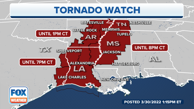
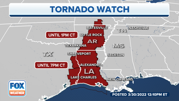
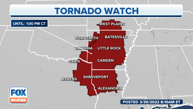
Tornado Watches are in effect until 1 p.m. Central time.
NOAA's Storm Prediction Center has issued the following severe weather watches:
A Tornado Watch is valid until 9 a.m. Central time for portions of northwestern Arkansas, including Fort Smith.
A Tornado Watch is valid until 1 p.m. Central time for parts of Arkansas, northern Louisiana, southern Missouri, far southeastern Oklahoma, and northeastern and extreme East Texas. This watch area includes Little Rock in Arkansas, Shreveport in Louisiana and Longview in Texas.
For more information on Wednesday's severe weather threat, click here.
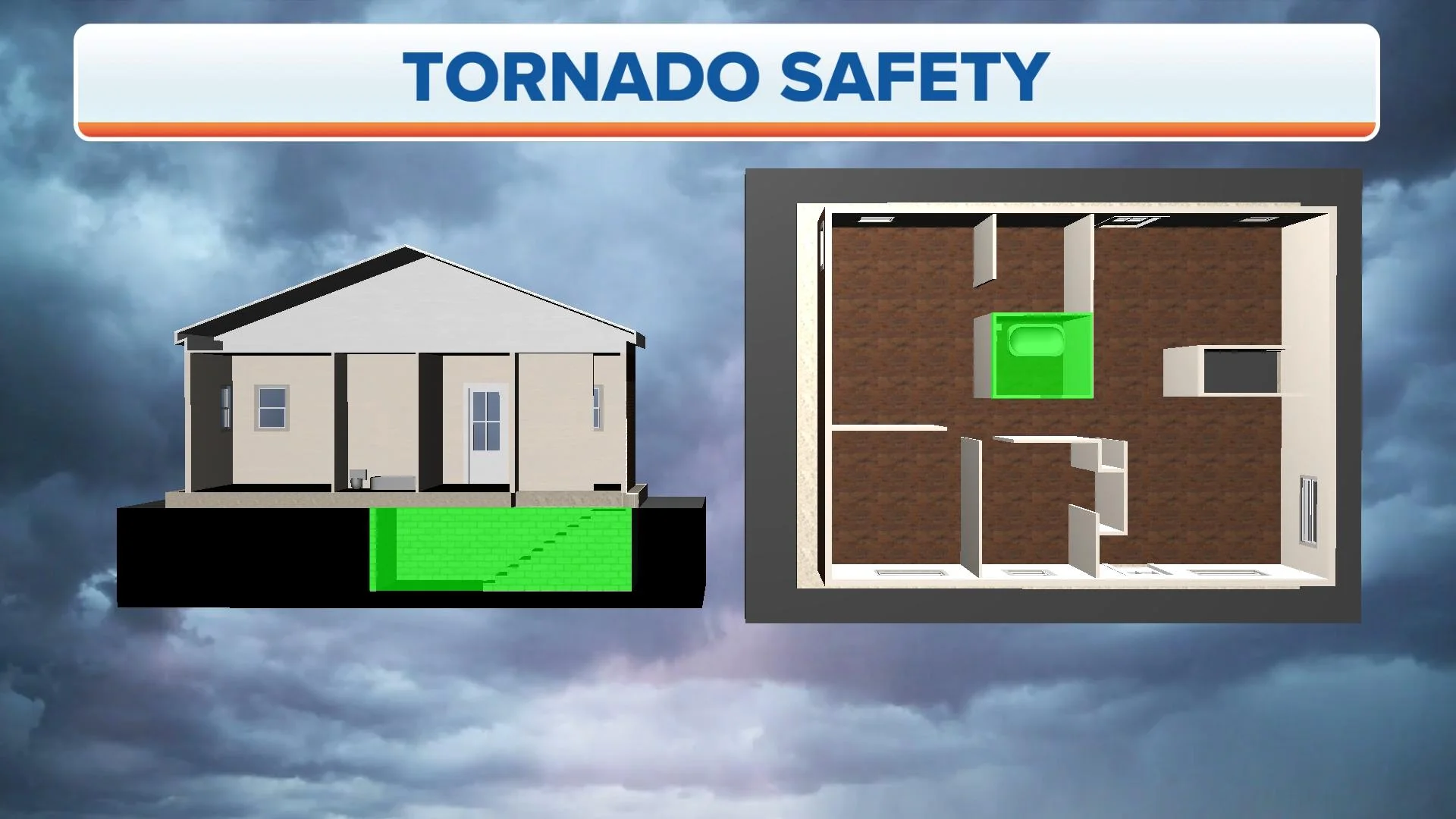
When it comes to driving and tornadoes, a lot of dangerous misconceptions exist, so it’s important to know what you should and shouldn’t do if you are driving when a tornado is on the ground.