These are the world's most powerful earthquakes on record
The Pacific Rim is home to most of the strongest quakes in history. Many of them have also created devastating tsunamis.
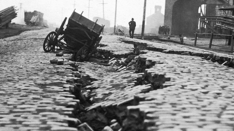
San Francisco 1906: The earthquake that shook up seismology
On April 18, 1906, San Francisco experienced a magnitude 7.9 earthquake. The quake and the fires it caused destroyed a large portion of the city by the bay.
Earthquakes are the natural result of movements by tectonic plates in our planet’s outermost layer.
According to the National Earthquake Information Center, it is estimated that millions of tremors happen every year. About 30,000 of them are ones that can be felt of cause damage. That works out to an average of about 82 impactful earthquakes each year.
Major earthquakes, meaning magnitude 7 or higher, happen about 16 times each year, according to the U.S. Geological Survey (USGS).
The most powerful earthquakes on record have happened in the most seismically active part of the world, called the Pacific Rim. It’s also known by a much more ominous moniker – The Ring of Fire. This is where the Pacific Plate meets with several other tectonic plates.
Here’s a closer look at the five strongest quakes on record, according to the USGS.
Valdivia Earthquake, 1960 – Magnitude 9.5
The strongest earthquake on record is a magnitude 9.5 quake that rocked Bio-Bio, Chile, on May 22, 1960. According to the National Centers for Environmental Information (NCEI), this temblor was just one in a series of quakes that lasted for days and ruptured a 600-mile-long section of fault.
The main quake also created a tsunami that destroyed part of the Chilean coast but was also seen on shorelines throughout the Pacific Ocean.
As many as 5,700 people are believed to have been killed, and about 3,000 were injured by the quakes and tsunami.
WHEN AN EARTHQUAKE CAUSED THE MISSISSIPPI RIVER TO FLOW BACKWARDS
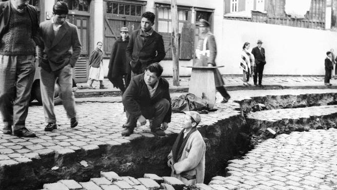
People looking at an enormous crack on a street due to the earthquake that struck the Chile area on May 22, 1960.
(STF/AFP / Getty Images)
Great Alaska Earthquake, 1964 – Magnitude 9.2
This great earthquake struck the area of Prince William Sound in Alaska on March 24, 1964. The magnitude 9.2 temblor lasted for about 3 minutes and was felt over a large area of Alaska and in parts of the Yukon Territory and British Columbia in Canada, according to the NCEI.
Landslides triggered by the quake created an estimated 20 tsunamis and devastated many towns along the Gulf of Alaska. Serious damage was also reported in British Columbia, Hawaii and the west coast of the U.S. mainland.
About 140 people were killed.
ALASKA EXPERIENCES AN EARTHQUAKE EVERY 10 MINUTES, SCIENTISTS SAY
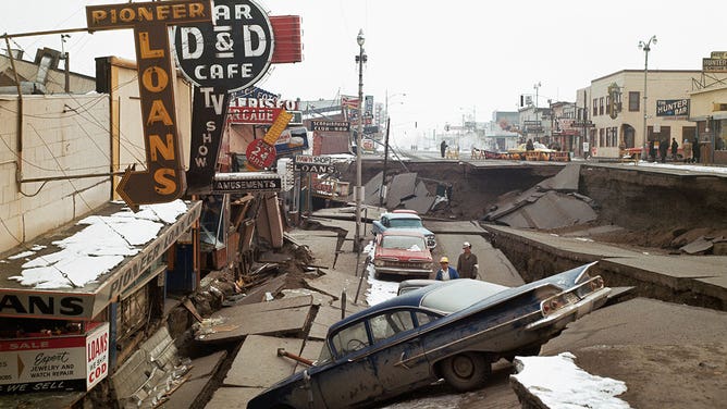
Damage is seen in Alaska on March 29, 1964, after a tremendous earthquake struck days earlier.
(UPI color photo / Getty Images)
Sumatra Earthquake, 2004 – Magnitude 9.1
An enormous magnitude 9.1 earthquake jolted an area off the west coast of Northern Sumatra in Indonesia on Dec. 26, 2004. The quake happened offshore in the Indian Ocean, but it resulted in a devastating tsunami that ran ashore in several countries that border the water, according to the USGS.
On the 10th anniversary of the disaster, the International Tsunami Information Center (ITIC) reported nearly 228,000 people were reported dead or missing across 14 countries. After a reanalysis by scientists, the number of countries with casualties increased to 15 as the 20th anniversary of the earthquake approached. Indonesia experienced the brunt of the disaster, with more than 167,000 reported dead or missing.
The earthquake is the third-largest on record, but the resulting tsunami is the deadliest in recorded history.
WHY EARTHQUAKES ARE FELT DIFFERENTLY ON EITHER SIDE OF THE U.S.
![Sumatra Earthquake and Tsunami 2004]() Image 1 of 3
Image 1 of 3This photograph taken by tourist Eric Skitzi shows a tsunami wave hitting the beach of Batu Ferringhi on Penang island, Malaysia, Dec. 26, 2004. (AFP)
![2004 Sumatra earthquake and tsunami]() Image 2 of 3
Image 2 of 3In this U.S. Navy handout, damage from the tsunami is seen from a U.S. Navy helicopter Jan. 6, 2005, in Meulaboh, Sumatra, Indonesia. (Jordon R. Beesley/U.S. Navy)
![2004 Sumatra earthquake and tsunami]() Image 3 of 3
Image 3 of 3A boat and one of the gift shop buildings are submerged on the beach of Phi Phi island in southern Thailand's holiday resort which was destroyed by a tsunami Dec. 27, 2004. (ROSLAN RAHMAN/AFP)


Tohoku Earthquake, 2011 – Magnitude 9.1
On March 11, 2011, a magnitude 9.1 earthquake rocked the area off the east coast of Honshu, Japan.
According to the NCEI, the resulting tsunami arrived on a 1,200-mile-long stretch of the Japanese coast within 30 minutes with waves that reached a maximum height of 130 feet. The water easily overtopped seawalls, flooding and destroying everything in its path.
1700 EARTHQUAKE OFF U.S. COAST CAUSED AN ‘ORPHAN TSUNAMI’ IN JAPAN
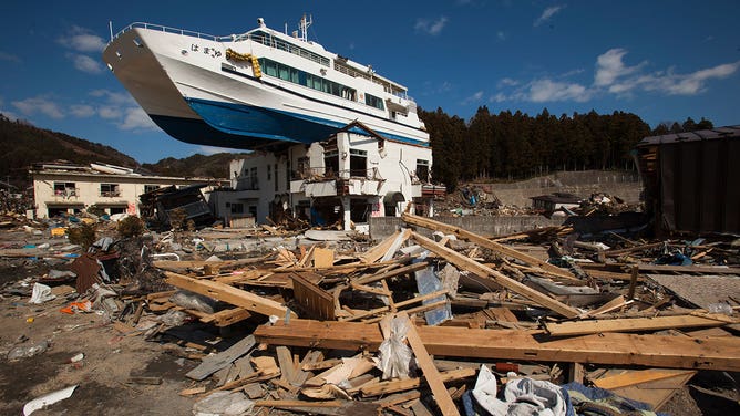
The Hamayuri, a catamaran sightseeing boat, sits atop a two-story Japanese inn building in the tsunami debris on on April 3, 2011, in Iwate Prefecture, Japan.
(Athit Perawongmetha / Getty Images)
The water also flooded nuclear power plants in the region, most notably at the Fukushima Daiichi plant. While the power was shut off automatically when the earthquake was detected, the tsunami waves destroyed systems meant to keep the reactions that generate power at the facility in check. According to the ITIC, the result was a meltdown and dangerous radiation leaks.
More than 18,000 people were killed by the disaster, including some victims who were never recovered.
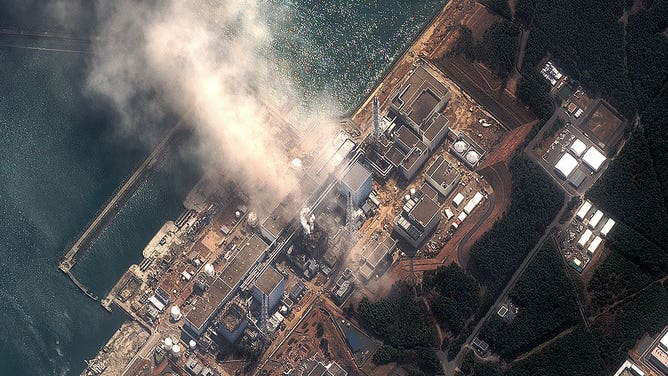
In this satellite view, the Fukushima Dai-ichi Nuclear Power plant after a massive earthquake and subsequent tsunami on March 14, 2011, in Futaba, Japan.
(DigitalGlobe / Getty Images)
Kamchatka Peninsula, 1952 – Magnitude 9.0
A magnitude 9.0 earthquake struck just off the coast of the Kamchatka Peninsula in Russia on Nov. 4, 1952.
The temblor resulted in a tsunami that traveled across the Pacific Ocean, reaching the Hawaiian Islands several hours later. The waves reached a height of about 33 feet in parts of the islands, according to the USGS. Extensive damage was done to beaches, piers, boats and roads.
The tsunami eventually reached the other side of the Pacific Ocean, where waves nearly 5 feet high were reported in California.
No U.S. fatalities were reported because of the disaster. According to the NCEI, information about fatalities in Russia was hard to come by because the disaster was deemed a state secret by the then-Soviet Union. However, research after the fall of the USSR showed the death toll reached an estimated 10,000.
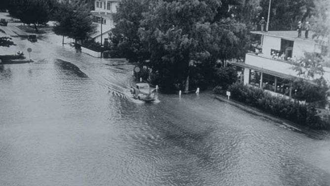
A street on Midway Island is flooded after a tsunami hit Nov. 4, 1952.
(NCEI / NOAA)