The history of the pioneers behind the Atlantic hurricane season forecasts
CSU has been issuing forecasts for nearly 40 years
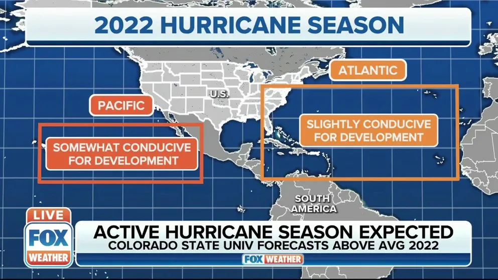
Colorado State University: Busier than average hurricane season expected
The experts at Colorado State University expect the 2022 Atlantic hurricane season to be an active one with tropical cyclone activity expected to be above average. FOX Weather Hurricane Specialist Bryan Norcross with more.
FORT COLLINS, Colo. – When you think of Colorado, you think of hurricanes, right?
Next to NOAA, the most highly regarded tropical season forecast comes from Colorado State University.
The soon-to-be-released annual outlook predicts the amount of tropical cyclone activity that the Atlantic basin sees during the season.
History of CSU tropical forecast
Lead author of the forecast, Phil Klotzbach, says while he wasn't part of the initial team that put out the schools' first outlooks, he's happy to be a part of the 39th year.
"I was not a part of the first seasonal forecast in 1984. I was four years old, starting nursery school," Klotzbach joked. "It all got started with Dr. Bill Gray, who basically was the first one anywhere to do these season hurricane predictions for the Atlantic."
The Colorado State team was founded by the late Dr. William Gray, who led the program for decades.
"He made fundamental contributions to all sorts of tropical meteorology," Klotzbach says about Gray. "He was like Wikipedia before there was Wikipedia. He was kind of an online encyclopedia."
A look back at Hurricane Katrina
More than a decade later, some communities in New Orleans are still trying to recover from Hurricane Katrina.
Gray was able to associate the amount of hurricane activity with climate patterns.
"Dr. Gray was very much an empiricist," Klotzbach explains. "His thing was always you look at the data, and you find these kinds of relationships, and then you try to understand the physics as to why it's there."
Gray knew that when there were years with El Niño, the hurricane season tended to be quieter.
"It was basically through that El Niño discovery that these seasonal forecasts got going," he says.
WHAT LA NINA’S CONTINUATION INTO SUMMER COULD MEAN FOR WEATHER
How the annual forecast is made
Climate patterns aren't the only ingredients that CSU examines to determine how many tropical cyclones could form during a year.
Klotzbach and his team use 70 years of historical data, including sea surface temperatures, sea level pressure, and wind shear.
And while the data helps with the year-to-year hurricane variability, Klotzbach says they have built statistical models to help guide them on a number and use different predictors.
"The final numbers are often basically just kind of an average of what those models outputs will give us," he says. "We will tweak the numbers up or down a little bit, depending on other facts that we look at. I would say the final numbers are a little bit qualitative in that they aren't necessarily going to be just simply the average of what our guidance gives us, but they're going to be very close to that."
The models that CSU use gives them the expected Accumulated Cyclone Energy (ACE), which is an integrated metric that accounts for the frequency, intensity and duration of storms.
Klotzbach and his team look at the normal amount of ACE and assess the probability of the number of storms, hurricanes and major hurricanes.
CSU says that the report summarizes all tropical cyclone activity in the Atlantic basin during the hurricane season and compares the team's seasonal and two-week forecasts to what occurred.
EXPERTS PROVIDE FIRST GLIMPSE OF POTENTIALLY ANOTHER BUSY ATLANTIC HURRICANE SEASON
With the 2021 forecast, CSU correctly predicted the above-average season. The ACE was very close to what occurred – approximately 120% of the 1991-2020 average.
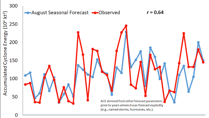
CSU Predicted vs Observed Atlantic Accumulated Cyclone Energy
What's in store for the 2022 season?
While Klotzbach couldn't detail the exact numbers of what his team will soon release, he did provide insight into how active the season could be.
"We think the odds of El Niño are quite low. The Atlantic is looking reasonably conducive," Klotzbach explains. "Even though we haven't finalized anything yet, I'd say the odds are below average. I would say we are probably leaning more towards above-average [storms]."
Colorado State will issue the forecast live from the National Tropical Weather Conference at 10 a.m. ET.