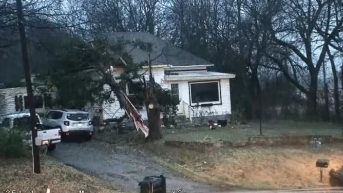
Tornadoes confirmed in Georgia and Mississippi after severe weather, flash flooding slam the South
Severe storms brought damaging winds, flooding and tornadoes to the South on Friday and Saturday.
Confirmed tornado reported near Atlanta metro in Georgia
Severe storms are barreling through the Southeast, where radar confirmed a tornado near Newnan, Georgia on Saturday morning. A ground stop was issued at Hartsfield-Jackson Atlanta International Airport on Saturday as storms moved in.
JACKSON, Miss. — Multiple tornadoes touched down in Mississippi and Georgia during severe storms on Friday and Saturday, causing damage in their path, according to the National Weather Service.
Severe storms brought damaging winds, flooding and tornadoes to the South on Friday and Saturday.
AVALANCHE EVACUATIONS ADVISED FOR JUNEAU RESIDENTS AS ATMOSPHERIC RIVER SLAMS ALASKA
A Tornado Warning was in effect for Fulton County, Georgia, and radar confirmed a tornado northwest of Newnan, Georgia, on Saturday morning.
A ground stop was issued for Hartsfield-Jackson Atlanta International Airport due to thunderstorms Saturday as the storms moved through the area.
AIRPORT GROUND STOPS VS. GROUND DELAYS: WHAT ARE THEY AND HOW DO THEY HAPPEN?
Severe storms barreled through the South on Friday, spawning a series of Tornado Warnings and at least three National Weather Service-confirmed tornadoes in Mississippi, two EF-1s and one EF-0.
The National Weather Service said the storms caused multiple trees to become uprooted.
Heavy rain triggered flash flood advisories across several states in the region, including Louisiana, Mississippi and Alabama, soaking many areas that are currently in a drought, elevating the risk for flash flooding.

Warning boxes are color coded as: Severe Thunderstorm Warnings in yellow, Tornado Warnings in red, Tornado Warnings with confirmed tornado in purple, Flash Flood Warnings in green, and Flash Flood Emergencies in pink.
(FOX Weather)
In a classic set up for severe weather in the South, multiple rounds of severe storms thrashed from the Tennessee Valley to the Gulf Coast.

(FOX Weather)
A corridor across Southern Mississippi near Hattiesburg and south of Jackson saw rain rates of up to 3 inches per hour Friday, according to the FOX Forecast Center.

(FOX Weather)
Video from Saturday morning out of Pell City, Alabama, showed flooding covering a roadway.
The National Weather Service issued a Flash Flood Warning for a few counties in Alabama through late Saturday morning.
Watch: Flooding covers roadway in Pell City, Alabama during severe storms
A Flash Flood Warning was issued for Pell City on Saturday morning as heavy rain caused flooding on roads in the area. Severe storms are moving through the Southeast on Saturday, bringing the possibility of damaging winds, flooding and even some tornadoes.
The continued threat of tornadoes came after a strong EF-2 tornado ripped through Purcell, Oklahoma, on Thursday as a line of storms moved through the area.
Though no injuries were reported, the tornado left a trail of destruction, downing power lines and uprooting trees.

A radar-confirmed tornado ripped across Interstate 35 and part of Purcell, Oklahoma Thursday morning, knocking down power lines as a powerful line of thunderstorms barreled their way across the Southern Plains.
(KWTV/KOTV via NNS / FOX Weather)
TORNADO RIPS THROUGH PURCELL, OKLAHOMA SPAWNING TRAIL OF DAMAGE
In addition to the EF-2 that ripped through Purcell, the National Weather Service Norman Office confirmed three more tornadoes in Oklahoma: an EF-0 near Lake Thunderbird, an EF-1 near the Shawnee Twin Lakes and an EF-1 in north Shawnee.
Areas including Central and Southern Alabama, Western Georgia and the Carolinas also saw severe storms on Saturday.
CROSS COUNTRY STORM EXPECTED TO DAMPEN NFL WILD CARD WEEKEND
The possibility of flash flooding remains across east Tennessee and western North Carolina.

