'Destructive' thunderstorm alerts: What they are and why the National Weather Service issues them
These new 'destructive' Severe Thunderstorm Warnings will automatically trigger a Wireless Emergency Alert on your cell phone
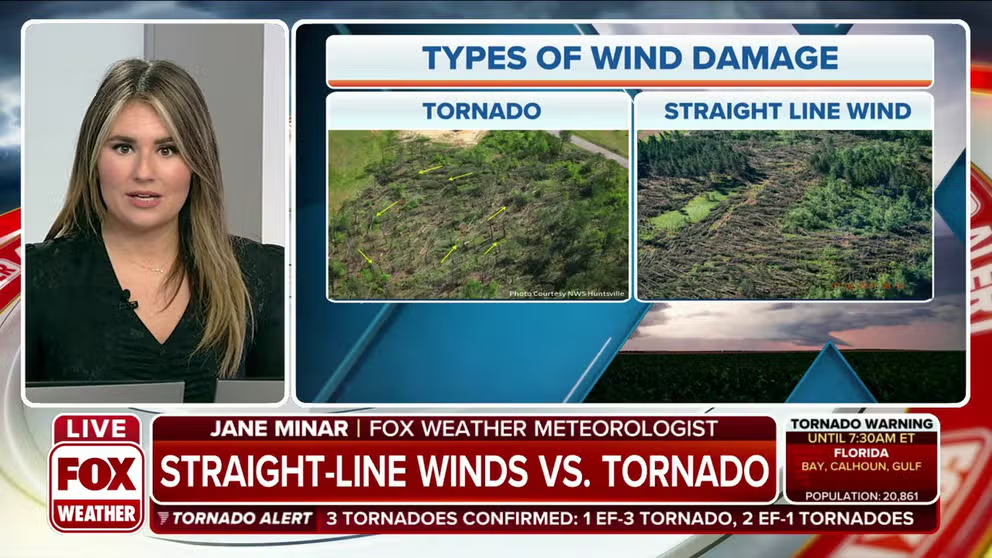
Straight-line wind damage vs. tornado: What's the difference?
FOX Weather meteorologist Jane Minar explains the difference between the types of wind damage: straight-line winds and a tornado.
A severe thunderstorm doesn't have to spawn a tornado to be destructive. That's why the National Weather Service made a change to its Severe Thunderstorm Warnings to help make you aware of these potentially life-threatening storms.
By definition, a thunderstorm is considered severe when it produces hail of 1 inch in diameter (quarter-sized) or larger, winds of at least 58 mph and/or a tornado, according to the NWS.
As of Aug. 2, 2021, the NWS can now better convey the severity and potential impacts from thunderstorm winds and hail by adding a "damage threat" tag to Severe Thunderstorm Warnings, similar to the messaging that was already being used in Tornado and Flash Flood Warnings.
WATCH VS. WARNING: HERE ARE THE DIFFERENCES BETWEEN THESE WEATHER TERMS THAT COULD SAVE YOUR LIFE
The three damage threat categories include "destructive" and "considerable" damage, as well as a baseline or "base" Severe Thunderstorm Warning (which remains unchanged from the previous warning method).
According to an NWS press release, the new destructive damage category conveys to the public that urgent action is needed and a life-threatening event is occurring, which may cause substantial damage to property. Any thunderstorms categorized as destructive will trigger a Wireless Emergency Alert (WEA) on your cell phone, just like a Tornado or Flash Flood Warning.
HOW TO WATCH FOX WEATHER ON TV
These warnings are not coming from your phone's FOX Weather app. Instead, they are based on the GPS location of your cell phone, and you can turn them on or off in your phone's settings.
A WEA will not be triggered for the considerable damage tag or the base Severe Thunderstorm Warning. Only the destructive damage tag will trigger a WEA on your phone.
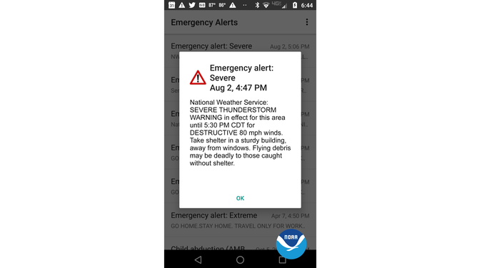
An example of a Wireless Emergency Alert showing the new "destructive" Severe Thunderstorm Warning.
(NWS)
What constitutes a "destructive" Severe Thunderstorm Warning?
Here are the criteria for each type of Severe Thunderstorm Warning now issued by the NWS:
- Destructive damage threat: At least 2.75-inch diameter (baseball-sized) hail and/or 80-plus-mph thunderstorm winds. Warnings with this tag will automatically activate a WEA on smartphones within the warned area.
- Considerable damage threat: At least 1.75-inch diameter (golf ball-sized) hail and/or 70-plus-mph thunderstorm winds. These warnings will not activate a WEA.
- Baseline or "base" Severe Thunderstorm Warning: At least 1-inch diameter (quarter-sized) hail and/or 58-plus-mph thunderstorm winds. These warnings will also not activate a WEA. When no damage threat tag is present in the warning, damage is expected to be at this base level.
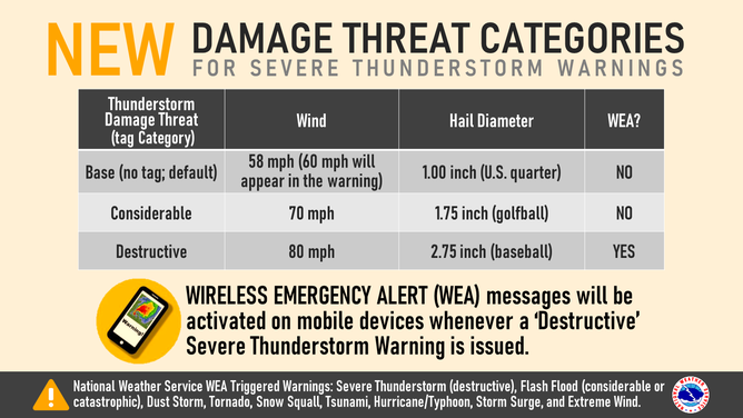
(NWS)
In the United States, only 10% of all severe thunderstorms reach the destructive category each year, on average. The NWS said most of these storms are either damaging-wind events such as derechoes or supercells, the latter of which can produce very large hail along their path.
NO, THIS ISN'T THE APOCALYPSE; LEARN THE SCIENCE BEHIND THESE JAW-DROPPING SHELF CLOUDS
All NWS Severe Thunderstorm Warnings continue to be issued and distributed on weather.gov, NOAA Weather Radio, the Emergency Alert System and through dissemination systems to its emergency managers and partners. The recent addition of damage threat tags is part of the broader Hazard Simplification Project to improve communication of watches and warnings to the public.