NASA’s Perseverance rover captures stunning selfie in ancient martian terrain
The rover assembled 61 images showcasing the region the mission team calls Lac de Charmes.

FILE: NASA ESCAPADE mission to study Mars and space weather
NASA launched ESCAPADE (Escape and Plasma Acceleration and Dynamics Explorers) on Nov. 13, 2025, which is a mission to investigate how the Sun continues to influence Mars and will begin to study space weather in new ways.
NASA’s Perseverance rover took a selfie in front of ancient Mars terrain.
BREATHTAKING VIEWS: NASA RELEASES 12,000 NEW PHOTOS FROM ARTEMIS II MISSION
The rover assembled 61 images showcasing the region the mission team calls Lac de Charmes.
The selfie captures Perseverance "training its mast on a rocky outcrop on which it had just made a circular abrasion patch, with the western rim of Jezero Crater stretching into the background."
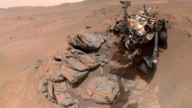
NASA’s Perseverance Mars rover took a self-portrait against a sweeping backdrop of ancient Martian terrain at a location the science team calls "Lac de Charmes."
(NASA/JPL-Caltech/ASU/MSSS / NASA)
The photos were taken on March 11 during the rover’s westward journey beyond the crater rim. According to scientists, the Lac de Charmes region represents some of the most scientifically compelling terrain Perseverance has explored so far.
HOW OFTEN DO METEORITES CRASH IN THE US?
"We took this image when the rover was in the ‘Wild West’ beyond the Jezero Crater rim — the farthest west we have been since we landed at Jezero a little over five years ago," Katie Stack Morgan, Perseverance’s project scientist at NASA Jet Propulsion Laboratory in Southern California, said.
Along with the selfie, the rover also captured 46 images of the "Arbot" area within Lac de Charmes. The photos offered some of the richest geological imagery of the mission, revealing a landscape filled with diverse rock formations.
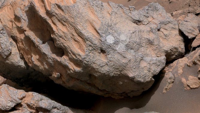
The rover grinded down a portion of the rock’s surface, allowing the science team to analyze what’s inside.
(NASA/JPL-Caltech/ASU/MSSS / NASA)
"What I see in this image is excellent exposure of likely the oldest rocks we are going to investigate during this mission," Ken Farley, Perseverance’s deputy project scientist at California Institute of Technology in Pasadena, said.
The images provide NASA scientists with a clearer roadmap for investigating the ridge line and its wide variety of rocks.
THE BEST CELESTIAL EVENTS IN 2026 YOU WON'T WANT TO MISS
Some of the formations appear to be megabreccias, massive fragments, some the size of skyscrapers, hurled into place by a powerful meteorite impact.
"There is a sharp ridge line visible in the mosaic whose jagged, angular texture contrasts starkly with the rounded boulders in the foreground," Farley said. "We also see a feature that may be a volcanic dike, a vertical intrusion of magma that hardened in place and was left standing as the softer surrounding material eroded away over billions of years."

See the Mars surface from the Curiosity rover
NASA’s Curiosity rover captured a clear panorama of Mars' Gale Crater in August.
The rover also grinded down a portion of the rock's surface, allowing the team to see what’s inside a rocky outcrop nicknamed "Arathusa."
The team determined that the rock was composed of igneous minerals that likely predate the formation of Jezero Crater.
POTENTIAL TO SEE EXTRAORDINARY ‘SUNGRAZER’ COMET SQUASHED AS IT LIKELY DISINTEGRATED NEAR THE SUN
"The rover’s study of these really ancient rocks is a whole new ballgame," Stack Morgan said. "These rocks especially if they’re from deep in the crust could give us insights applicable to the entire planet, like whether there was a magma ocean on Mars and what initial conditions eventually made it a habitable planet."