New summer weather outlook looks toasty across much of US as June looms less than 50 days away
According to NOAA, the warmest summers on record in the U.S. occurred in 2021 and 1936, when the average temperatures were 2.60 °F above typical values. The El Niño and the Southern Oscillation (ENSO) could be in the neutral or La Nina stage during the summer.

What you need to know about summer travel this year
Today is the official start of summer – Travel expert Jeanenne Tornatore explains what you need to know about summer travel this year and what to do if your trip gets disrupted by the weather.
The latest climate outlook for the upcoming summer shows much of the Lower 48 will continue to bake with temperatures that are well-above average, with varying amounts of precipitation across the country.
NOAA’s Climate Prediction Center released its updated seasonal outlooks on Thursday, which showed the probability of regions seeing above-normal, near-normal, and below-normal temperatures and precipitation. That includes the period of meteorological summer which begins on June 1 and stretches to Aug. 31.
WHY SUMMER SHOULD ACTUALLY BEGIN ON JUNE 1
Forecasters stated that an emerging La Niña will start to influence weather patterns across North America, but it is unclear exactly when the climate pattern will emerge.
The establishment of ridges of high pressures across the western U.S. and southeast Canada will likely result in significant heat waves, which could help challenge record temperatures in the regions.
The outlooks set the country up for what very well could be one of the warmest summers in history, outpacing records set in 2021 and 1936.

Summer temperature outlook
(NOAA)
The only section of the country that could be in store for close to average temperatures is the Upper Midwest, which is a flip from the El Nino-influenced winter when the region experienced some of the warmest anomalies.
The extreme warmth that has dominated most of the year is not unexpected as Britain’s national weather service, the Met Office, previously called for global temperatures in 2024 to finish as much as 1.58 degrees C (2.84 degrees F) above average.
The European Union’s Copernicus Climate Change Service said global temperature anomalies in 2023 were around 1.48 degrees C (2.66 degrees F) higher than the running mean.
Despite warm temperatures, rainfall to stick around
Usually, when warm temperatures dominate, a region sees below-average rainfall, but NOAA forecasters don’t believe that will be the case east of the Mississippi River.
The agency’s precipitation outlook for June, July and August showed most states in the eastern U.S. seeing the highest chances of rainfall tallies that will be above normal.
NOAA cited the growing emergence of a La Niña over the Pacific as being one of the main influences of weather patterns during the second half of 2024.
The precipitation outlook does not offer good news for all, with vast areas of the West likely seeing below-average rainfall.
This includes the Desert Southwest, where the annual monsoon is usually in full swing during the late summer, but in the latest forecast, it is not an apparent significant factor during the upcoming season.
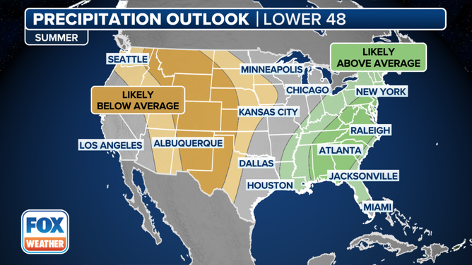
Summer precipitation outlook
(NOAA)
When neither El Niño or La Niña are in control
Several climate organizations around the Pacific Ocean consider the basin’s El Niño-Southern Oscillation (ENSO) state to now be in a neutral status, though NOAA's latest update on April 11 still has the region in an El Niño Advisory. But even they give significant odds (85%) El Niño will dissipate this spring.
The neutral state of the El Niño-Southern Oscillation (ENSO) occurs when water temperature anomalies in the eastern and central Pacific are between 0.5 degrees C (0.9 degrees F) and -0.5 degrees C.
All occurrences of neutral summers over the last two decades have produced seasons that had temperatures above their typical values.
On the precipitation front, most regions of the country also see average or above-average rainfall during neutral events.
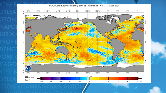
Water temperature anomalies across globe
(NOAA)