Texas faces tornado threat as needed rain returns to South on Thursday
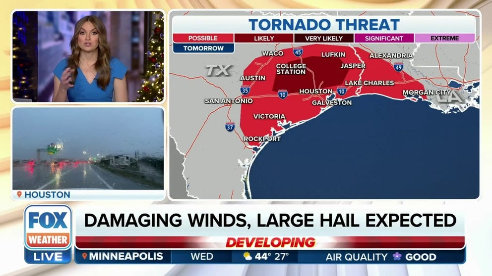
The severe weather threat is expected to develop during the late-morning hours on Thursday and continue into the evening, with the highest threat of severe storms focused over southeastern Texas, including parts of the Houston metro area.
Severe weather targets southeast Texas on Thursday
Damaging winds, large hail and tornadoes are possible on Thursday for southeast Texas on Thursday as thunderstorms moving through College Station, Bryan and Conroe.
HOUSTON – Severe weather is expected to return to Texas on Thursday as a soggy setup brings plenty of rain to the South and Southeast into the weekend, providing beneficial moisture and drought relief from the Gulf Coast states to Florida.
Starting Thursday, an area of high pressure will shift east as clockwise winds around the high allow a southerly flow to send moisture from the Gulf of Mexico to Texas and the Gulf Coast states.
FLASH DROUGHT INCREASING ACROSS SOUTHEAST DRIVES WILDFIRE GROWTH
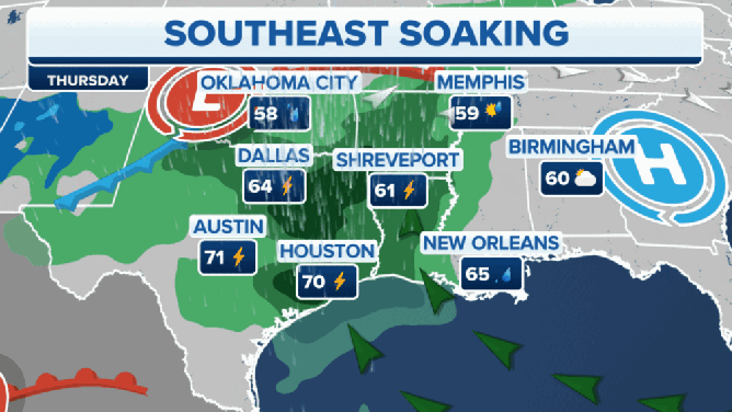
As the rain event begins in the Lone Star State, it will include a risk for severe thunderstorms, including tornadoes, damaging winds and large hail. This slow-moving storm system will continue bringing rain from Louisiana to the Carolinas through the weekend.
The Southeast rain setup from Thursday through Sunday.
(FOX Weather)
Severe weather threat for Texas, Gulf Coast states
There are threats of severe weather and flash flooding on Thursday and Friday.
The severe weather threat is expected to develop during the late-morning hours on Thursday and continue into the evening, with the highest threat of severe storms focused over southeastern Texas, including parts of the Houston metro area.
(FOX Weather)
Forecasters with NOAA's Storm Prediction Center (SPC) have issued a Level 3 out of 5 risk for severe thunderstorms on Thursday over a small portion of southeastern Texas, including College Station, The Woodlands, Bryan, Conroe and Spring.
The highest risk will be from late Thursday morning through mid-afternoon across southeastern Texas, according to the SPC, with severe storms and a few tornadoes possible.
There is a Level 2 out of 5 risk for severe weather on Thursday in other parts of southeastern Texas, including Houston, and eastward into southwestern Louisiana, including Lake Charles.
Scattered thunderstorms will shift the severe weather threat into the central Gulf Coast states on Friday, where there is a Level 1 out of 5 risk for severe thunderstorms in New Orleans and Baton Rouge in Louisiana and Birmingham, Montgomery and Mobile in Alabama.

(FOX Weather)
Storms could also produce flash flooding
As the rain moves into urban areas on Thursday, flooding is possible for cities such as Houston, Shreveport in Louisiana and Little Rock in Arkansas.
From Friday afternoon through Saturday morning, a flash-flood threat will be possible from New Orleans to Panama City, Florida.

(FOX Weather)
Rain needed to lift drought conditions
The rainy forecast is much needed for Mississippi and Louisiana, which are facing exceptional drought, the worst conditions on the U.S. Drought Monitor.

(FOX Weather)
The South has some of the driest cities in the U.S. right now, including Chattanooga in Tennessee, Jackson in Mississippi and Birmingham in Alabama. In Tennessee, Louisiana, Mississippi and Alabama, rain totals have been more than 7 inches below average since Sept. 1.
By Friday, the system will stall over the Gulf Coast, setting Louisiana, Mississippi and Alabama up for back-to-back rainy days.
Multiple inches of rain is likely from southeastern Texas to the Florida Panhandle as the wet weather sticks around through Sunday.
This wet pattern will likely continue next week as the FOX Forecast Center is tracking more moisture surging into the South.