Flood alerts in effect across California as another powerful atmospheric river storm aims for the Golden State
More atmospheric river storms are expected to hit California this week. The FOX Forecast Center warns that it’s becoming more likely that the flooding threat from the strongest storm will be more serious than last week’s storm.
Major flooding expected in California this week
Another series of powerful atmospheric river storms will bring more rain and damaging winds to California this week.
Preparations are underway across California as another series of powerful atmospheric river storms will continue to drench the state one week after a deadly bomb cyclone brought heavy rain, damaging winds, mudslides and rough surf to the region.
At least two deaths have been blamed on the bomb cyclone in the San Francisco Bay area, including a child who was killed on Wednesday when a large tree fell onto his home and a 19-year-old woman who hydroplaned while driving and crashed into a utility pole.
MOST OF CALIFORNIA TO SEE RISK OF FLOODING DUE TO NEXT ATMOSPHERIC RIVER STORM ON MONDAY
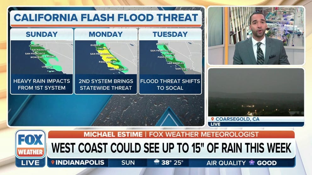
Millions of people in California are under a Flood Watch until at least Wednesday.
(FOX Weather)
The latest atmospheric river storm will push into California late Sunday night and early Monday morning, bringing heavy rain and damaging wind to the region.
And unlike the previous storm, which mainly affected central and northern California, the storm at the start of the workweek will impact millions from the California-Oregon border south through the Lost Angeles Basin.
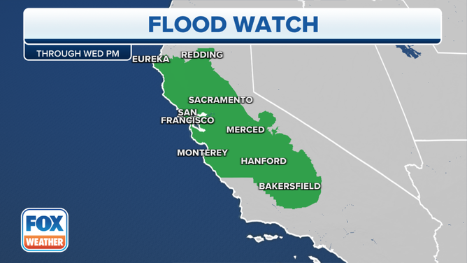
As a result of the incoming storm, Flood Watches have been posted across the state and will remain in effect through at least Wednesday.
Burn scar areas at risk of flooding, mudslides
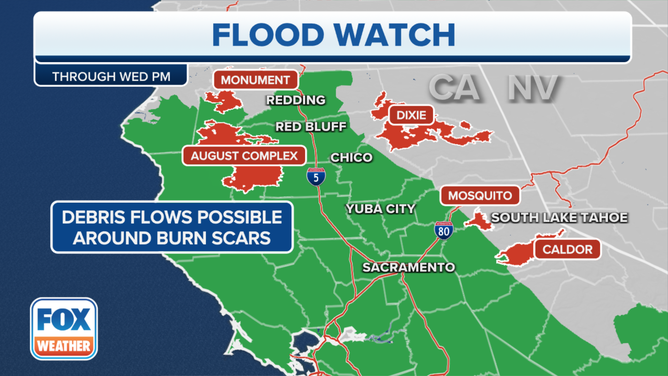
Flood Watches are in effect across California until at least Wednesday.
(FOX Weather)
Many areas included in the Flood Watches have also been the scene of major wildfires over the years, and there are concerns that the heavy rain could lead to mudslides.
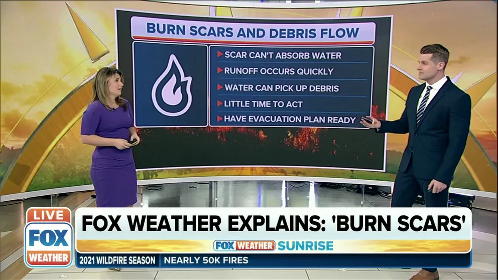
Areas of vegetation and the landscape where wildfires have scorched the area are known as burn scars. Those steep regions create a heightened right of flooding and mudslides.
FOX Weather explains: 'Burn scars'
Flash floods and mudslides often follow wildfires which leave the ground charred and unable to absorb water.
When fires burn through those areas, a layer of ash forms on the topsoil while a water-repellent coating is just below the layer of ash, according to the National Weather Service. Water-repellent soils form when organic materials, such as trees, shrubs, plants and litter burn at high intensities.
Water-repellent compounds are vaporized and condense on colder soil layers below, which prevents soil from absorbing water. When the rain starts to fall over these regions, the risk of a debris flow (or a mudslide) increases.
Rivers continue to rise as another atmospheric river takes aim at California
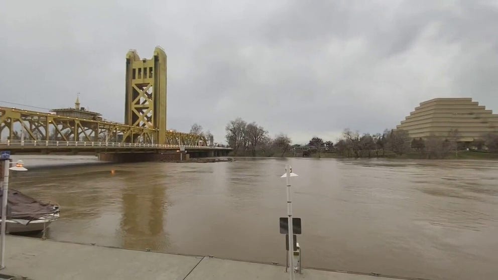
Watch: Water levels on Sacramento River continue to rise
Water levels in the Sacramento River have risen as a powerful atmospheric river continues to bring heavy rain to California.
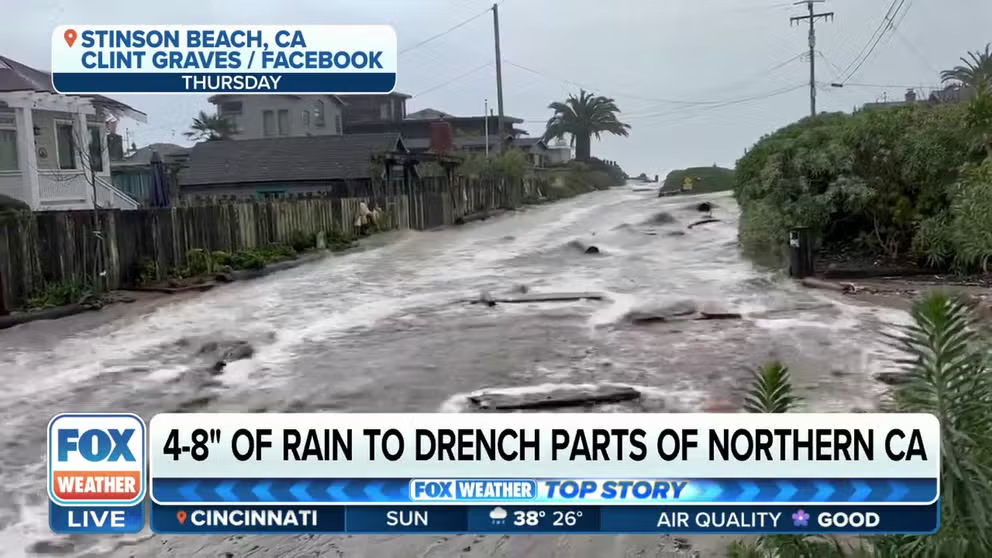
Several areas of the state, from the California-Oregon border south through the San Francisco Bay area and into Southern California, will likely see several inches of rain this week.
In all, 4-7 inches of rain could fall across the lower elevations in northern California. But along the Coastal Ranges and the Sierra Nevada foothills, as much as 10-15 inches of rain could fall.
In Southern California, rainfall totals over the next seven days could be between 1-4 inches in the lower elevations up to as much as 8 inches in the mountains surrounding the LA Basin.
The city of West Sacramento said the city's public works department had restocked the sandbag supply in advance of more heavy rain that's headed to the region.
Residents have been advised to prepare for the storm, which could impact travel because of wet roads and the possibility of flooding and other debris covering roadways across the region.
It's recommended to take it slow on the roads and allow for extra time to ensure you arrive at your final destination safely.
PLAN, PREPARE, PROTECT: HOW TO BEST COVER YOUR PROPERTY AGAINST FLOODS
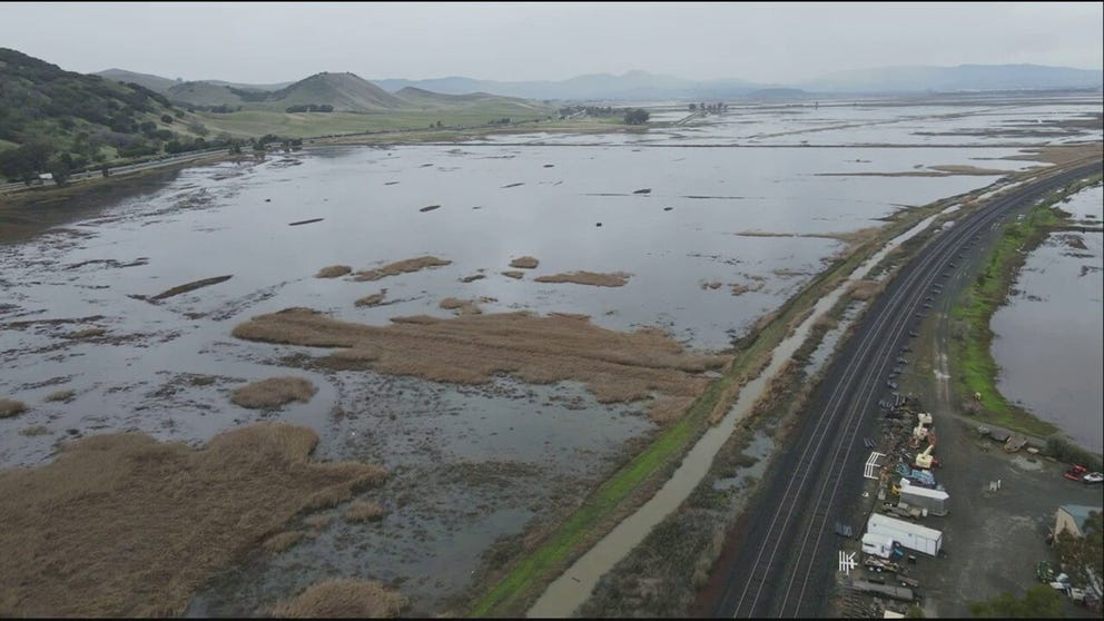
Watch: Drone captures video of flooding near Benicia, California
A drone was able to capture incredible video of flooding next to Interstate 680 near the community of Benicia, California.
And while residents are preparing for another storm, officials are continuing to keep a close eye on local streams and rivers.
The FOX Forecast Center said there's a lot of moisture associated with this atmospheric river storm, and it's becoming increasingly likely that the flooding experienced will be worse than any of the previous storms over the past few weeks.
National Weather Service explains what makes this atmospheric river different than the others
Another atmospheric river storm is expected to impact California starting late Sunday night or early Monday morning. Brooke Bingaman, the lead forecaster with the National Weather Service in San Francisco joined FOX Weather on Sunday to explain what’s different with this storm system.
"Typically, California sees about five to seven good atmospheric rivers each year that contribute to our water supply," said Brooke Bingaman, lead forecaster with the National Weather Service in San Francisco. "What’s different with this one that’s coming, the amount of moisture in the air that’s approaching the West Coast is at least 250-300% of what we normally see in the air as it’s approaching the West Coast."
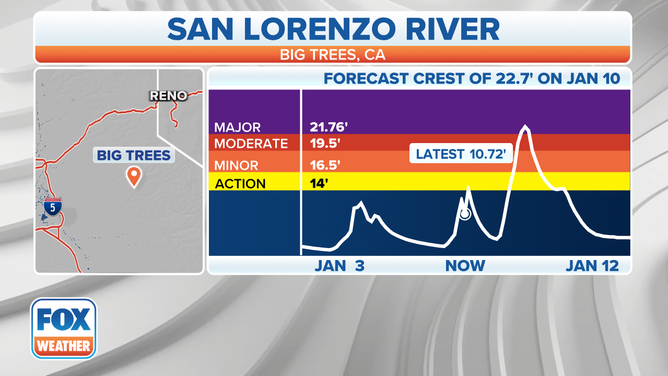
![The forecasted crest of the San Lorenzo River at Big Trees, California]() Image 1 of 4
Image 1 of 4The forecasted crest of the San Lorenzo River at Big Trees, California ( )
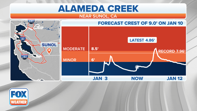
![The forecasted crest of the Alameda Creek near Sunol, California.]() Image 2 of 4
Image 2 of 4The forecasted crest of the Alameda Creek near Sunol, California. ( )
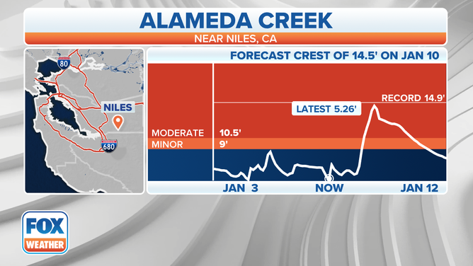
![The forecasted crest of the Alameda Creek near Niles, California.]() Image 3 of 4
Image 3 of 4The forecasted crest of the Alameda Creek near Niles, California. ( )
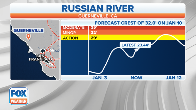
![The forecasted crest of the Russian River near Guerneville, California.]() Image 4 of 4
Image 4 of 4The forecasted crest of the Russian River near Guerneville, California. ( )
What else is unique with this storm, Bingaman said, is the fact that California has been hit with so many of these storms.
"So, we just keep piling on these waves of rain after rain," she said. "So, that’s what’s making this storm more unique."
Because of the saturated soil, small rivers and streams will likely flow out of their banks quickly.
The water will then flow into larger rivers, and that will increase the risk of widespread flooding across the northern half of the state.