Severe weather returns to central US this week ahead of summer solstice
On Monday, NOAA's Storm Prediction Center highlighted an area across Minnesota with a Level 3 out of 5 risk for severe thunderstorms. This area includes much of southern Minnesota, including Minneapolis, St. Paul and Bloomington.
Millions from Plains to Great Lakes region face early-week severe weather threat
Tens of millions of people from the Plains to the Great Lakes region will be at risk of seeing powerful thunderstorms through the middle of the upcoming workweek. FOX Weather Meteorologist Jane Minar breaks down the forecast on June 15, 2025.
A series of pieces of energy are setting the stage for multiple days of severe weather across the north-central U.S. early this week in a region that has largely missed out on enhanced rainfall.
According to the FOX Forecast Center, most of the thunderstorm development will take place along frontal boundaries, which will only slightly shift from day to day, setting up a pattern for persistent rain.
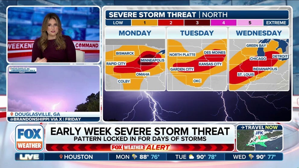
Through Wednesday, more than 45 million people across the central U.S. face potential severe thunderstorms.

(FOX Weather)
Depending on the day’s activity, cities such as Minneapolis in Minnesota, Omaha in Nebraska, Des Moines in Iowa and Kansas City in Missouri find themselves in an elevated thunderstorm risk zone.
On Monday, NOAA's Storm Prediction Center highlighted an area across Minnesota with a Level 3 out of 5 risk for severe thunderstorms. This area includes much of southern Minnesota, including Minneapolis, St. Paul and Bloomington.
A lesser Level 2 out of 5 risk is posted for other parts of Minnesota, South Dakota, Iowa and Wisconsin.

(FOX Weather)
Any thunderstorm can be dangerous with cloud-to-ground lightning and heavy rainfall, but in the strongest storms, damaging wind gusts and large hail will be possible.
Forecasters have not ruled out a tornado threat, but the tornadic element is not considered as substantial as it would be in supercells with ample wind shear.
Summer ushers in severe weather season for Upper Midwest
June and July are typically when the northern Plains and Upper Midwest experience their most adverse weather from thunderstorms.
According to NOAA's Storm Prediction Center, more than 200 tornadoes form every year during the first month of meteorological summer, with many impacting the Dakotas, Minnesota, Iowa and Nebraska.
In addition to tornadoes, the country annually sees around 3,100 reports of damaging winds, which can occur in nearly any state in the Lower 48.
Until a recent pattern shift, communities across the southern tier of the country had been subject to nonstop rounds of severe weather, which was unusual considering the time of year.
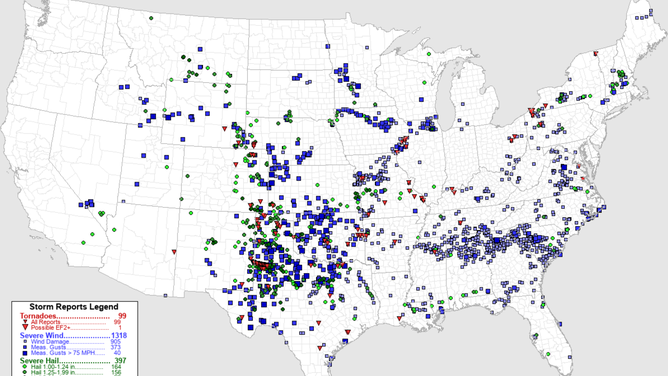
June 2025 severe weather reports
Alongside bouts of severe weather, many areas also reported flooding, which, in some cases in Oklahoma and Texas, occurred as drivers were caught off guard in their vehicles.
According to NWS forecasters, just 6 inches of fast-moving water can knock an adult off their feet, and a foot of floodwater can carry a car away.
Fortunately, the FOX Forecast Center does not believe the current unsettled pattern will lead to widespread flooding concerns, as the thunderstorms’ forward momentum will be rather quick and more than two-thirds of the region is considered unusually dry.

(FOX Weather)
HOW ABSENCE OF EL NIÑO, LA NIÑA COULD INFLUENCE ACTIVE HURRICANE SEASON FORECAST
The general pattern could feature mesoscale convective systems (MCS), which can travel hundreds of miles across the northern tier of the country.
The formation of an MCS usually happens during the warmer months when nighttime temperatures are sufficient to aid in thunderstorm development, without relying solely on daytime heating.
Once an MCS forms, it can essentially take on a life of its own, generating weather features that help it maintain strength and structure well after initial development.
These weather systems are an important part of climate patterns, as some areas from the Gulf Coast to the Midwest rely on complexes of thunderstorms for more than 50% of their annual rainfall.
Squall lines and derechos are considered to be types of MCS events, which can lead to significant crop damage and billions of dollars in losses.
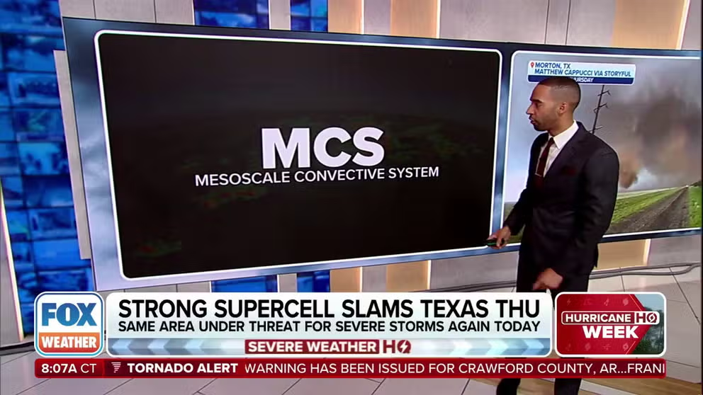
What is a mesoscale convective system?
A mesoscale convective system is complex of thunderstorms which becomes organized and persists for several hours.