Nearly a dozen killed after flash flooding swamps San Antonio area, leading to water rescues
The San Antonio Fire Department reported that, in addition to 11 fatalities, several people remain unaccounted for and the number of victims could rise.

Houston floods as torrential rain, thunderstorms move in Thursday
Torrential rain and thunderstorms pushing across portions of Texas led to reports of flooding in cities like San Antonio and Houston, and more rain is on the way. FOX Weather Correspondent Katie Byrne was in Houston with the latest on June 12, 2025.
SAN ANTONIO – Nearly a dozen people have been found dead following days of significant rainfall around San Antonio, according to local first responders.
As much as 8 inches of rainfall fell in parts of the region over a short period of time between Wednesday night and Thursday morning, which triggered the flooding.
The San Antonio Fire Department reported that, in addition to 11 fatalities, several people remain unaccounted for and the number of victims could rise.
![Photos show flooding across Matagorda, Texas on June 12, 2025. Photos taken early Thursday morning, showing homes and vehicles flooded across the South Texas Community after heavy rainfall.]() Image 1 of 14
Image 1 of 14Photos show flooding across Matagorda, Texas on June 12, 2025. Photos taken early Thursday morning, showing homes and vehicles flooded across the South Texas Community after heavy rainfall. (Kurt Linda Berckmans)
![Photos show flooding across Matagorda, Texas on June 12, 2025. Photos taken early Thursday morning, showing homes and vehicles flooded across the South Texas Community after heavy rainfall.]() Image 2 of 14
Image 2 of 14Photos show flooding across Matagorda, Texas on June 12, 2025. Photos taken early Thursday morning, showing homes and vehicles flooded across the South Texas Community after heavy rainfall. (Kurt Linda Berckmans)
![Photos show flooding across Matagorda, Texas on June 12, 2025. Photos taken early Thursday morning, showing homes and vehicles flooded across the South Texas Community after heavy rainfall.]() Image 3 of 14
Image 3 of 14Photos show flooding across Matagorda, Texas on June 12, 2025. Photos taken early Thursday morning, showing homes and vehicles flooded across the South Texas Community after heavy rainfall. (Kurt Linda Berckmans)
![Photos show flooding across Matagorda, Texas on June 12, 2025. Photos taken early Thursday morning, showing homes and vehicles flooded across the South Texas Community after heavy rainfall.]() Image 4 of 14
Image 4 of 14Photos show flooding across Matagorda, Texas on June 12, 2025. Photos taken early Thursday morning, showing homes and vehicles flooded across the South Texas Community after heavy rainfall. (Kurt Linda Berckmans)
![Photos show flooding across Matagorda, Texas on June 12, 2025. Photos taken early Thursday morning, showing homes and vehicles flooded across the South Texas Community after heavy rainfall.]() Image 5 of 14
Image 5 of 14Photos show flooding across Matagorda, Texas on June 12, 2025. Photos taken early Thursday morning, showing homes and vehicles flooded across the South Texas Community after heavy rainfall. (Kurt Linda Berckmans)
![Photos show flooding across Matagorda, Texas on June 12, 2025. Photos taken early Thursday morning, showing homes and vehicles flooded across the South Texas Community after heavy rainfall.]() Image 6 of 14
Image 6 of 14Photos show flooding across Matagorda, Texas on June 12, 2025. Photos taken early Thursday morning, showing homes and vehicles flooded across the South Texas Community after heavy rainfall. (Kurt Linda Berckmans)
![Photos show flooding across Matagorda, Texas on June 12, 2025. Photos taken early Thursday morning, showing homes and vehicles flooded across the South Texas Community after heavy rainfall.]() Image 7 of 14
Image 7 of 14Photos show flooding across Matagorda, Texas on June 12, 2025. Photos taken early Thursday morning, showing homes and vehicles flooded across the South Texas Community after heavy rainfall. (Kurt Linda Berckmans)
![Photos show flooding across Matagorda, Texas on June 12, 2025. Photos taken early Thursday morning, showing homes and vehicles flooded across the South Texas Community after heavy rainfall.]() Image 8 of 14
Image 8 of 14Photos show flooding across Matagorda, Texas on June 12, 2025. Photos taken early Thursday morning, showing homes and vehicles flooded across the South Texas Community after heavy rainfall. (Kurt Linda Berckmans)
![Photos show flooding across Matagorda, Texas on June 12, 2025. Photos taken early Thursday morning, showing homes and vehicles flooded across the South Texas Community after heavy rainfall.]() Image 9 of 14
Image 9 of 14Photos show flooding across Matagorda, Texas on June 12, 2025. Photos taken early Thursday morning, showing homes and vehicles flooded across the South Texas Community after heavy rainfall. (Kurt Linda Berckmans)
![Photos show flooding across Matagorda, Texas on June 12, 2025. Photos taken early Thursday morning, showing homes and vehicles flooded across the South Texas Community after heavy rainfall.]() Image 10 of 14
Image 10 of 14Photos show flooding across Matagorda, Texas on June 12, 2025. Photos taken early Thursday morning, showing homes and vehicles flooded across the South Texas Community after heavy rainfall. (Kurt Linda Berckmans)
![Photos show flooding across Matagorda, Texas on June 12, 2025. Photos taken early Thursday morning, showing homes and vehicles flooded across the South Texas Community after heavy rainfall.]() Image 11 of 14
Image 11 of 14Photos show flooding across Matagorda, Texas on June 12, 2025. Photos taken early Thursday morning, showing homes and vehicles flooded across the South Texas Community after heavy rainfall. (Kurt Linda Berckmans)
![Photos show flooding across Matagorda, Texas on June 12, 2025. Photos taken early Thursday morning, showing homes and vehicles flooded across the South Texas Community after heavy rainfall.]() Image 12 of 14
Image 12 of 14Photos show flooding across Matagorda, Texas on June 12, 2025. Photos taken early Thursday morning, showing homes and vehicles flooded across the South Texas Community after heavy rainfall. (Kurt Linda Berckmans)
![Heavy rainfall on 6/12/2025 causes flooding around Houston County, Texas.]() Image 13 of 14
Image 13 of 14Heavy rainfall on 6/12/2025 causes flooding around Houston County, Texas. (TxDOT)
![Heavy rainfall on 6/12/2025 causes flooding around Houston County, Texas.]() Image 14 of 14
Image 14 of 14Heavy rainfall on 6/12/2025 causes flooding around Houston County, Texas. (TxDOT)


"Our hearts are with the families of those we’ve lost to this week’s flash floods and the families who continue searching for their loved ones," San Antonio Mayor Ron Nirenberg said in a statement.
Since the start of the flooding event, firefighters have responded to more than 70 water rescues and over a dozen more high water investigations.
"If you are missing a loved one who may have been impacted by the flood and are unable to locate them, please call the San Antonio Police Department (SAPD) at 210-207-4817," the city said in a statement.

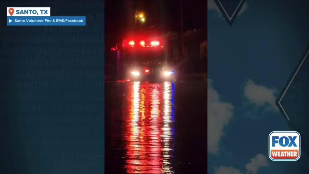
Watch: Flooding reported in Santo, Texas
A video shared from Santo, Texas, shows significant flooding that occurred on Thursday, June 12, 2025.
Officially, San Antonio has picked up 6.67 inches of rain over the past two days, with more than 6 inches of that falling Thursday. This makes Thursday the wettest June day on record in San Antonio, nearly doubling the city's previous daily record of 3.26 inches set in 1973.
Thursday was originally reported to be San Antonio's 8th-wettest day overall since records began in July 1885, but a recalculation of the day's total rainfall moved it to the 10th-wettest day overall.

(FOX Weather)
More than 3 inches of rain fell in the New Braunfels area, northwest of San Antonio, in about 30 minutes.
A video recorded in Santo, Texas, showed significant flooding taking place as the heavy rain fell.
Another video showed first responders rescuing residents from flooding conditions on Panama Road. Officials said water as high as 4 feet was reported in some areas, with "water flowing swiftly in most areas."
KNOW YOUR FLOOD TERMINOLOGY: WHAT FLOOD WATCHES, WARNINGS AND EMERGENCIES REALLY MEAN
Watch: Residents rescued from floodwaters in Santo, Texas
A video shared from Santo, Texas, shows residents being rescued after flooding early Thursday morning. Officials said water as high as 4 feet was reported in some areas.
The National Weather Service said 40 low-water crossings were closed in Bexar County alone, along with several others in Comal and Hays counties.
In addition, Leon Creek at Loop 410 near Leon Valley in the San Antonio area rose sharply by 13 feet in two hours and had more than 41,000 cubic feet of water per second flowing through it.
Along the Texas coast, Matagorda County issued a disaster declaration on Thursday due to the severe weather and flash flooding in the region. According to the Matagorda County Emergency Operation Center, the disaster declaration now authorizes officials to take necessary actions to mitigate the impact of the storm and ensure the safety of residents.
Photos from Matagorda County showed how dire the situation was Thursday morning. Floodwaters could be seen creeping dangerously close to homes while water covers green space and roads across the area.
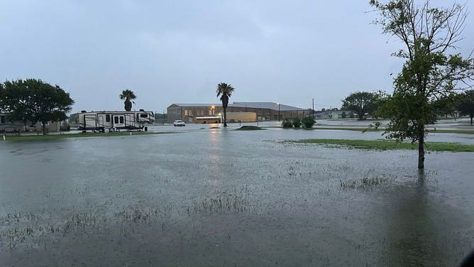
Photos show flooding across Matagorda, Texas on June 12, 2025. Photos taken early Thursday morning, showing homes and vehicles flooded across the South Texas Community after heavy rainfall.
(Kurt Linda Berckmans / FOX Weather)
In Victoria, residents had been told to stay home for safety due to the flooding.
"The Victoria Office of Emergency Management has not issued a shelter-in-place order," officials said on Facebook. "However, due to current weather and road conditions, residents are advised to stay home for their safety."
Flooding was also reported in Houston. FOX Weather Correspondent Katie Byrne was in Houston on Thursday morning and shared video of high water in the Lake Houston Forest neighborhood.
In addition to the flooding rain, the storms packed a punch.
Numerous homes were damaged when a tornado with 100-mph winds touched down behind some apartments northeast of Wharton just after 3 a.m. Thursday. Preliminary surveys by the National Weather Service Office in the Houston/Galveston region found damage consistent with an EF-1 twister.
Another tornado with a preliminary rating of EF-0 touched down east of Burr and caused tree damage along County Road 117, according to the NWS.
DOWNLOAD THE FREE FOX WEATHER APP

(FOX Weather)