White Thanksgiving: Powerful snowstorm prompts blizzard warnings, dangerous whiteout conditions
Periods of whiteout and life-threatening driving conditions will be possible across Michigan's Upper Peninsula, as well as places downwind of Lakes Erie and Ontario in Ohio, western Pennsylvania and western New York, beginning Wednesday through Friday. People in Michigan's U.P. are being advised to avoid traveling on Wednesday and Thanksgiving Day.

Blizzard conditions confirmed in South Dakota amid blizzard warning
A blizzard warning is in effect for parts of Western Minnesota and Northeastern South Dakota through Tuesday night. Blizzard conditions in Aberdeen, South Dakota, were confirmed on Tuesday afternoon with reduced visibility and winds of 35-49 mph.
Blizzard warnings have been issued across parts of the Upper Midwest as a powerful snowstorm brings the potential to wreck Thanksgiving travel plans.
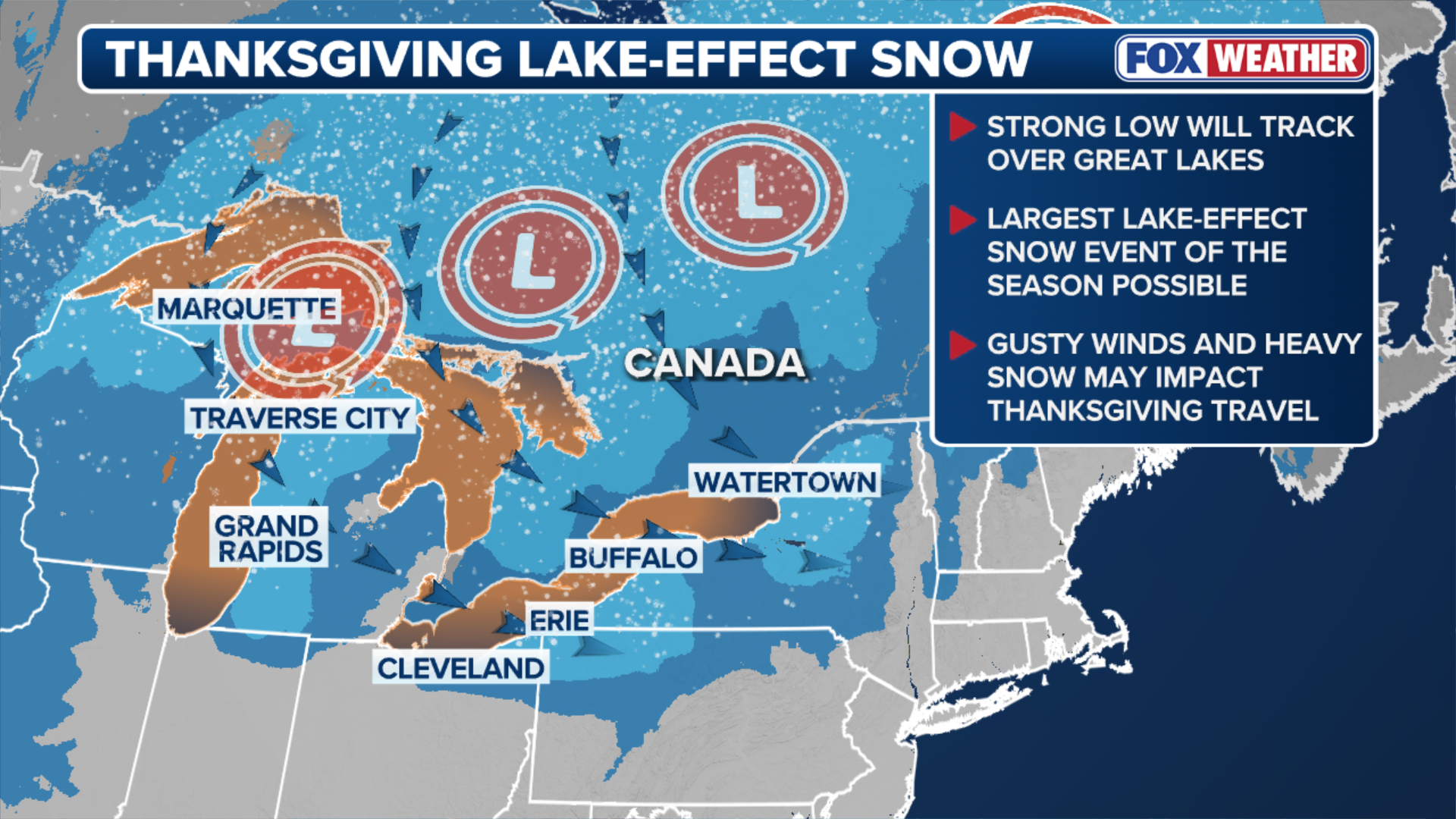
Thanksgiving travel could be snarled across the Great Lakes Snowbelts, as the FOX Forecast Center tracks what it expects to be the most significant lake-effect snow event of the season thus far beginning Wednesday and lasting through Thanksgiving Day and into Black Friday.
The National Weather Service office in Aberdeen, South Dakota, confirmed blizzard conditions on Tuesday afternoon, with reports of wind gusts between 35 and 49 mph and significantly reduced visibility at Aberdeen Regional Airport since Tuesday morning.
THANKSGIVING WEEK STORM LIVE TRACKER: RADAR, FLIGHT DELAYS AND CANCELLATIONS AND FORECASTS

Multi-vehicle pileup unfolded in Clay County, Minnesota, as the winter weather has created unsafe travel conditions
DRIVE SLOW: A multi-vehicle pileup has unfolded in Clay County, Minnesota, this evening as winter weather has created unsafe travel conditions in the region. Be sure to drive slowly and safely while traveling for the holidays this week.
Blizzard Warnings are in effect throughout parts of western Minnesota, northeastern South Dakota, northern Michigan and northwestern Wisconsin Tuesday with some alerts lasting through Friday.
More than six inches of snow was reported across parts of North Dakota on Tuesday afternoon.
Wind gusts of 50 mph will be possible across Michigan's Upper Peninsula, as well as places downwind of Lakes Erie and Ontario in Ohio, western Pennsylvania and western New York, which will create periods of whiteout and life-threatening driving conditions through Friday.

(FOX Weather)
The National Weather Service (NWS) has issued Winter Storm Watches for those locations beginning Wednesday, with most lasting through Friday evening. Confidence from computer forecast models continues to increase that Michigan's Upper Peninsula will see snowfall that will be measured in feet, all told.
The NWS office in Marquette advised people in Michigan's U.P. to alter their holiday plans and avoid traveling on Wednesday and Thanksgiving Day.
(FOX Weather)
This snow-making storm will follow a system out of the Northern Plains that is expected to bring mostly rain to the Great Lakes on Tuesday. Snow will likely be confined to the Dakotas and Minnesota, with the potential for a wintry mix by Wednesday, which will be driven by a fast-moving system out of the Northern Plains.
That initial round of moisture will lift back into Canada sometime on Wednesday, but arctic air is expected to wrap behind that system, creating the conditions for significant lake-effect snow in Michigan's U.P.

(FOX Weather)
The changeover from rain to snow itself could create hazardous driving conditions, although the exact timing of the changeover is not completely clear. Those who need to travel in the area on Wednesday afternoon should stay updated with the latest forecasts.
DRIVING ON THE ICE AND DRIVING ON THE SNOW
By Thanksgiving Day, lake-effect snow will be fully underway across the U.P. and snow bands could be intense and long-lasting. Marquette could see between 2-3 feet of snow through Friday, although snow totals will be highly dependent on wind direction.

(FOX Weather)
Meanwhile, the FOX Forecast Center said forecast uncertainty is higher around Lakes Erie and Ontario. But currently, computer forecast models are coming into agreement that the heaviest snow bands will set up over counties just south of Buffalo, New York, blanketing places in-and-around Dunkirk and Jamestown.
Winds are expected to shift on Friday and push snow bands farther south, according to the FOX Forecast Center.
HOW LA NIÑA, POLAR VORTEX WINDS COULD FUEL A FAST-START TO BRUTAL WINTER FOR PARTS OF THE US

Some Snowbelt locales in Ohio, Pennsylvania and western New York could see a foot of snow or more through Black Friday.
Be sure to watch FOX Weather for the latest on this developing story.