Winter storm spreading snow from mid-South to East Coast; travel impacts expected along I-95 corridor
Thursday is the snowiest day in Nashville, Tennessee, since Jan. 22, 2016
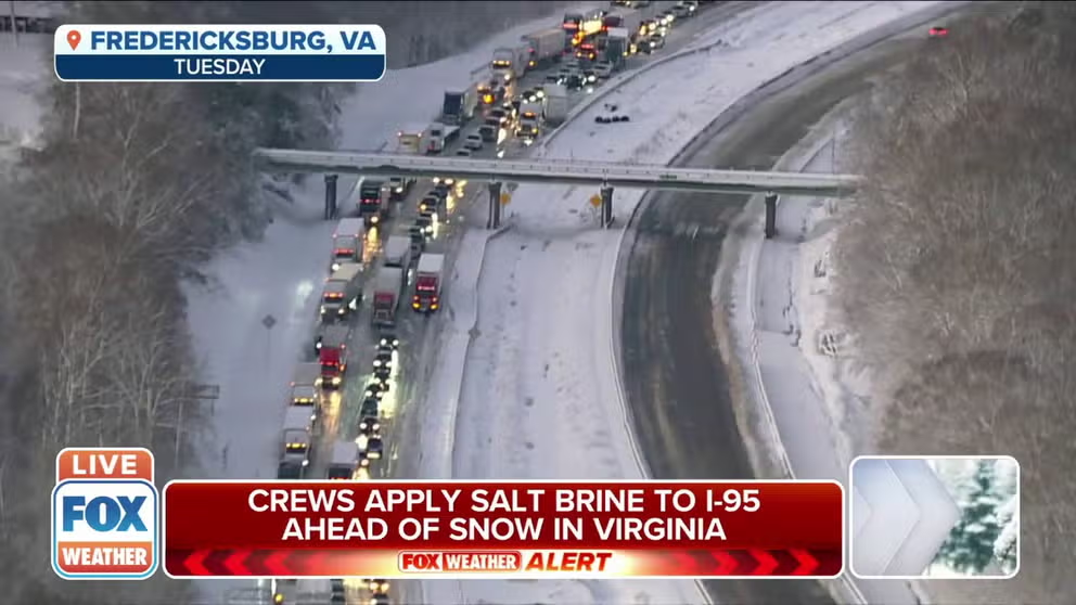
Crews apply salt brine to Virginia I-95 ahead of next storm
Crews in Virginia apply salt brine to Interstate 95 ahead of the next snowstorm in an effort to prevent another traffic nightmare.
A winter storm is spreading snow across the mid-South and will reach the East Coast by Thursday night, following closely on the heels of a storm that dumped more than a foot of snow from Virginia to New Jersey earlier this week.
The snow is causing travel delays along major interstates and secondary roadways, which is certainly not the news people want to hear after motorists were stranded on a portion of Interstate 95 in Virginia for nearly a day during the Sunday and Monday winter storm.
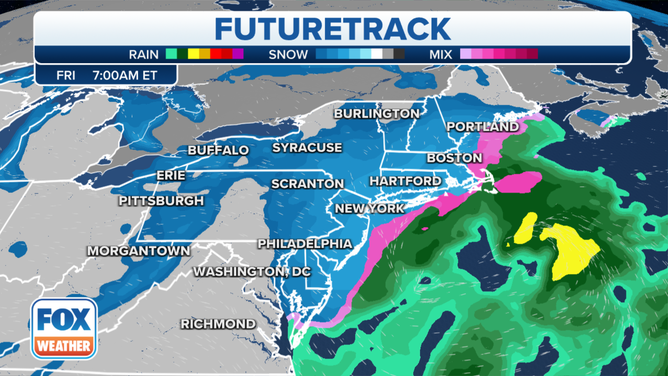
Northeast Futuretrack valid 7 a.m. Eastern time Friday, Jan. 7, 2022.
(FOX Weather)
Virginia Governor Ralph Northam has declared a state of emergency in advance of this storm. "While we typically have ample resources for snowstorms, these back-to-back events will generate landmark winter weather that requires extra flexibility," he said in a statement. The emergency order will cover costs of both storms.
According to the Virginia Department of Transportation, road crews in the Fredericksburg area began pre-treating Interstate 95 with a salt brine on Thursday morning. That will be followed by pre-treatment of the primary roads in the area.
LIVE UPDATES: WINTER STORM TAKES AIM AT MID-SOUTH, EAST COAST
Storm timeline: Mid-South
The National Weather Service has issued Winter Storm Warnings and Winter Weather Advisories across the mid-South. Cities under a Winter Storm Warning include Nashville, Tennessee; Lexington, Kentucky; and Charleston, West Virginia.
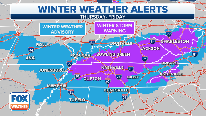
Winter weather alerts are in effect across the mid-South on Thursday, Jan. 6, 2022.
(FOX Weather)
Snow will quickly spread north and eastward through the day Thursday across Tennessee, Kentucky, the Ohio Valley and the central and southern Appalachians.
Rain is expected in the Deep South, though some snow, sleet or freezing rain might mix in as far south as northern Alabama and extreme northern Georgia.
Untreated roads, particularly bridges and overpasses, will likely turn slippery in areas that see snow or ice. Be prepared for hazardous driving conditions in Memphis, Nashville and Knoxville, Tennessee; Louisville and Lexington, Kentucky; and Charleston and Huntington, West Virginia.
7 THINGS YOU NEED TO KNOW ABOUT WINTER DRIVING
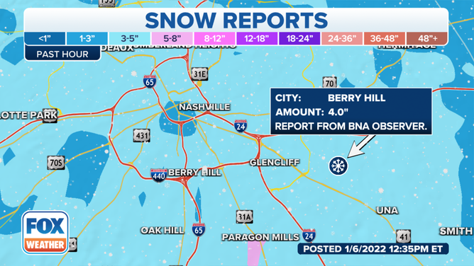
As of late Thursday, 6.3 inches of snow was measured at Nashville International Airport. It's also Music City's snowiest day since Jan. 22, 2016, when 8 inches piled up.
(FOX Weather)
Storm timeline: East Coast
The National Weather Service has issued Winter Storm Warnings, Winter Storm Watches and Winter Weather Advisories across the mid-Atlantic and Northeast. Boston and Providence, Rhode Island, are among the cities under a Winter Storm Warning. The entire New York City, Philadelphia, Baltimore and Washington metro areas are under Winter Weather Advisories.

Winter weather alerts are in effect across the mid-Atlantic and Northeast into Friday, Jan. 7, 2022.
(FOX Weather)
Thursday night, snow will continue in the central and southern Appalachians while also spreading into the mid-Atlantic and southern and central New England.
This includes the entire Interstate 95 corridor from Boston to New York City, Philadelphia, Baltimore, Washington and Richmond, Virginia.
The snow could turn heavy at times as the low-pressure system responsible for it strengthens near the East Coast.
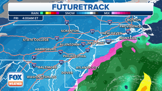
I-95 corridor Futuretrack valid 4 a.m. Eastern time Friday, Jan. 7, 2022.
(FOX Weather)
Travel conditions will be hazardous throughout this region Thursday night into Friday morning. The morning commute will likely be challenging due to falling snow and snow-covered roads along the Interstate 95 corridor between Boston and Washington.
VDOT: ‘COMPLETELY UNACCEPTABLE’ FOR DRIVERS TO BE STRANDED FOR HOURS ON INTERSTATE
Snow will gradually taper off in the mid-Atlantic through Friday morning, but it may linger much of the day in New England and be heavy at times before ending Friday evening. The storm will pull away from the Northeast on Friday night.
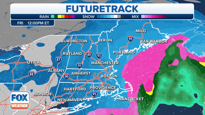
New England Futuretrack valid 12 p.m. Eastern time Friday, Jan. 7, 2022.
(FOX Weather)
Gusty winds could create areas of blowing and drifting snow at times, especially near the New England coast.
WHAT YOU SHOULD KNOW ABOUT BLOWING, DRIFTING SNOW
How much snow?
Between 1 and 5 inches of snow is forecast for many areas of Tennessee and Kentucky, including Nashville, Knoxville and Louisville. Less than an inch is expected in Memphis.
Some of the higher elevations of the central Appalachians will see snowfall totals on the order of 5 to 8 inches, particularly the mountains of eastern Kentucky and West Virginia, including parts of the Charleston metro area.
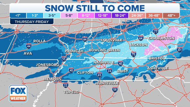
Snow forecast in the mid-South.
(FOX Weather)
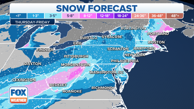
Between 3 and 5 inches is currently expected along much of the Interstate 95 corridor from New York City to Philadelphia and Washington.
Parts of eastern and southeastern New England, including the Boston metro area, could see 5 to 8 inches of snow from this winter storm. There might also be similarly higher totals in portions of southeastern New Jersey.
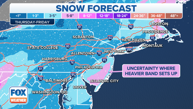
Snow forecast along the Interstate 95 corridor.
(FOX Weather)
If at least 1 inch of snowfall is recorded in New York and Boston, it will be the first 1-inch or greater snow event of the season for both cities. As of Thursday morning, only 0.2 inches has fallen in New York City, while Boston has picked up 0.4 inches so far.
CITIES IN ALABAMA, TENNESSEE HAVE RECEIVED MORE SNOW THAN NEW YORK CITY THIS WINTER
Snow forecast in the Northeast and mid-Atlantic.
(FOX Weather)