Halfway to Christmas: How El Nino could impact the upcoming winter
La Niña winters typically produce more widespread snowfall events than El Niños. El Niños usually lead to more snowfall in the eastern Rockies but large snowfall deficits can be experienced in the Upper Midwest.
What is an El Nino weather pattern
El Ninos are known to produce extreme weather around the globe. The world entered an El Nino in June 2023, and events are known to produce both good and bad impacts.
The countdown is on to the holiday season, with the year nearly halfway over and only about six months to go before Kris Kringle pays children around the world a visit.
Due to a warming central and eastern Pacific, the world is set to have its first full-fledged El Niño winter since 2018-19, which will mean some climate changes for the season from recent years.
Thanks to climatology and the FOX Weather app, meteorologists have a good sense of what temperatures and precipitation patterns could be in place by the end of the year.
On any Christmas Day, high temperatures tend to vary greatly across the Lower 48, thanks to the jet stream’s position, which is usually the demarcation between warm air to the south and cold air on the northern side.
During a typical winter El Niño pattern, an enhanced subtropical jet keeps the South cooler and stormier. The polar jet is often dislodged farther north, which keeps colder air bundled up over the extreme northern tier of the country and Canada.
The pattern can lead to impacts on everything from shoppers’ sentiment to travel delays to even who will see a white Christmas.
HERE’S WHAT AN EL NINO CLIMATE PATTERN IS
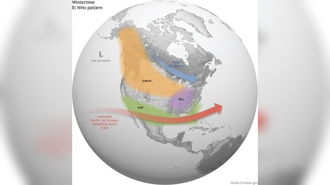
Classic El Niño set up
(NOAA)
Current El Niño was well forecast
NOAA officially declared the 2023 El Niño underway June 8 after water temperatures in the eastern and central Pacific warmed to more than 0.5 degrees Celsius above normal levels.
The entrance of El Niño into the worldwide weather pattern is the first time since 2019 that sea surface temperatures have reached this status.
Some climate models indicate that El Niño could be rather stout, with average anomalies reaching at least 1.5 degrees Celsius above average values.
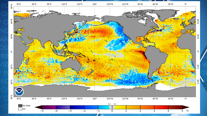
Water temperature anomalies around globe
(NOAA)
The last super El Niño events were in 1982-83, 1997-98 and 2015-16, but it remains to be seen whether 2023 will join the echelon.
According to NOAA, a typical El Niño lasts nine to 12 months, meaning that the current climate pattern could last well into 2024.
TRANSITION INTO EL NINO COULD LEAD TO RECORD HEAT AROUND GLOBE
Typical El Niño winter impacts
The impacts from the climate pattern are rather complex and vary depending on whether the world is in a weak, moderate or strong El Niño phase.
Typically, strong El Niños produce warm signals across much of the Lower 48, while more moderate events can lead to warmth or extreme cold. Weaker El Niños tend to produce the coldest winters out of the three stages.
Strong El Niños, or what are typically called Super Niños, are rare. When they do happen, California and parts of the West have reported the wettest winters on record, with significant snowfall over the Sierra Nevada and major flooding.
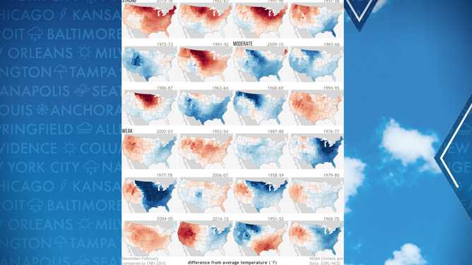
Winters of weak, moderate and strong El Ninos
(FOX Weather)
Elsewhere, snowfall can be hard to come by for the Midwest, and only average accumulation totals are reached along the East Coast.
La Niñas typically bring more snowfall to the northern tier, including the Plains and the Midwest.
Southern states typically see stormier weather than normal, and if cold enough, precipitation can fall in the frozen variety of ice or snow.
Last El Niño winter
The winter of 2018-19 was controlled by a weak El Niño pattern where water temperature anomalies never reached above 1 degree Celsius in the Pacific.
NOAA reported the season was the wettest winter on record with above-average precipitation, while regions in the Mississippi, Ohio and Tennessee river valleys and High Plains seeing an uptick in wet weather.
During the winter, Eau Claire, Wisconsin, broke its all-time snowiest month record with 53.7 inches falling during February. Las Vegas reported its first measurable snowfall in a decade and Flagstaff, Arizona, saw a record 35.9 inches of snow during a single day.
Despite the increased precipitation, temperatures came in 1.2 degrees Fahrenheit above average from December through February.
WHAT ARE THE ODDS OF A WHITE CHRISTMAS?
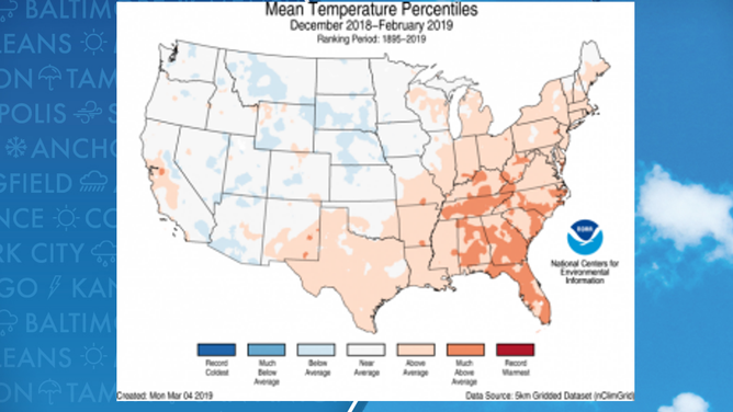
Winter 2018-2019 mean temperatures
(NOAA)
Florida had its second-warmest February on record, with Naples reaching 90 degrees.
Some of the states that reported their coldest temperatures were Montana, Wyoming, South Dakota and Nebraska.
No states reported temperatures extreme enough to set all-time records for record warmth or cold.
Christmas holiday forecast
On a typical Christmas Day, high temperatures tend to vary greatly across the Lower 48, thanks to the jet stream’s position, which usually is the demarcation between warm air to the south and cold air on the northern side.
Normal high temperatures on Dec. 25 in the Northeast are mostly in the 40s and 50s, while the Midwest usually sees highs in the 30s and 40s.
The Southeast tends to have the warmest air, with highs that reach the 50s, 60s and even 70s in parts of Florida.
On the West Coast, the weather can run the gamut from temperatures in the 20s and 30s along the Canadian border to 60s and 70s in the desert Southwest.
HOW TO WATCH FOX WEATHER ON TV
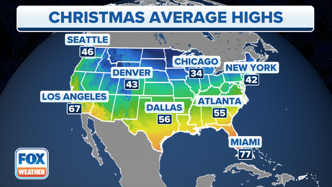
Average high temperatures on Christmas Day.
(FOX Weather)
FutureView is here to help
As you get ready to plan out vacations and holidays during the second half of the year, use the FutureView planning feature on the FOX Weather app to find out what the weather will be like.
FOX Weather’s FutureView allows you to track the weather for important dates up to nearly a year in advance.
In the FOX Weather app, click on the "Events" icon at the bottom of the screen to get started tracking the weather for weddings, vacations or even Christmas Day.
For example, the FOX Weather app expected mostly clear skies in Minneapolis on Dec. 25, with lows starting out in the single digits and highs in the lower 20s.
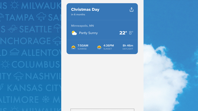
FOX Weather App forecast for Minneapolis, Minnesota, for Christmas Day 2023.
(FOX Weather)