Another storm system to bring rain, snow, wind to Pacific Northwest starting Sunday
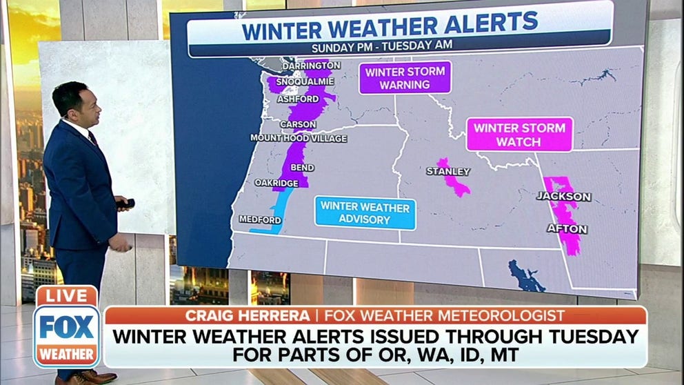
Winter Storm Warnings stretch across the Cascades from Darrington in northern Washington, south through the state and into central Oregon
Wet, windy weather returns to the Pacific Northwest
Another storm system will deliver rain and snow across the Pacific Northwest starting Sunday.
Another active pattern is on the way for the Pacific Northwest, bringing wet and windy weather to the region starting Sunday and lasting through the first half of the week.
HOW TO WATCH FOX WEATHER ON TV

Winter Storm Warnings stretch across the Cascades from Darrington in northern Washington, south through the state and into central Oregon, including Mount Hood Village, Bend and Oakridge.
A Winter Weather Advisory is in effect from central Oregon to the California border.

In addition to rain and snow, the winds will be quite strong.
High Wind Watches have been posted for eastern Washington through northern Idaho and across most of Montana.
High Wind Warnings are in effect further to the south in Oregon, where the National Weather Service in Medford said winds between 30-40 mph are expected, with some areas seeing gusts up to 65 mph.

While rain and snow are expected for the weekend, strong upper-level winds will provide the chance for enhanced rain and mountain snow to start the workweek.
With wind gusts up to 60 mph, blowing dust will reduce visibility in the lower elevations, while blowing snow will reduce visibility in higher elevations.
Significant snow is expected in higher elevations. The National Weather Service says that snow levels will fall to 2,000 feet come Monday.
"Snow will be measured in feet," FOX Weather meteorologist Samantha Thomas says. "The Washington and Oregon Cascades will be especially hard hit."

Lingering showers will continue Tuesday, but conditions are expected to improve.
By the time the storm system begins to wind down, several inches of rain are expected to fall in areas along the coast of Washington south into Oregon.