Battle of air masses will mean dramatic temperature divide for 200 million Americans
Troughing in the Western U.S. will allow temperatures to dip below normal for an extended period while a ridge in the Southeast will help pump warm air in.

Battle of air masses creating dramatic temperature divide across US
Troughing in the Western U.S. will allow temperatures to dip below normal for an extended period while a ridge in the Southeast will help pump warm air in.
A big shift in the jet stream that will allow for storminess in the West and dry weather in the Southeast has the potential to simultaneously lead to unusually warm and cold temperatures, with few areas not experiencing one of the extremes.
The FOX Forecast Center expects the cooler air mass to impact more than 100 million Americans, while warmer air will impact closer to 150 to 200 million residents.
The warm temperatures will continue across the eastern U.S. into the weekend as a ridge of high pressure will allow temperatures to reach 10-20 degrees above average.
The unseasonably warm weather will impact areas from Texas through the mid-Atlantic and into the Northeast, where plenty of 70s and even 80s will be fairly common.
"We’ve got lots of 80s back on the map in some cases, especially from Texas to Florida," FOX Weather meteorologist Craig Herrera said. "It’s tough because you have some nice warm weather out there but some more humidity in place. And then also the allergies have been pretty high in this part of the country."
A clash between the warm and cold air will also help trigger showers and thunderstorms during the remaining days of the workweek. The Storm Prediction Center is tracking the potential for a few of the storms becoming severe.
WHEN IS THE LAST FREEZE IN MY AREA?

Tracking the cold air
On the other hand, the FOX Forecast Center expects cold air that will settle into parts of the Northwest and Great Basin to lead to temperatures 20 to 30 degrees below average.
The air mass will likely not be cold enough to set record lows, but it does have a chance of keeping temperatures significantly from where they should be for this time of the year.

High temperatures in the 20s and 30s will be common throughout large parts of the mountain West.
The large-scale patterns are similar to the outlooks released by NOAA’s Climate Prediction Center for the spring.
Forecasters pointed to increased odds of a warmer-than-average spring along the Gulf and East coasts, while parts of the West see the effects of increased storminess and a deep snowpack.
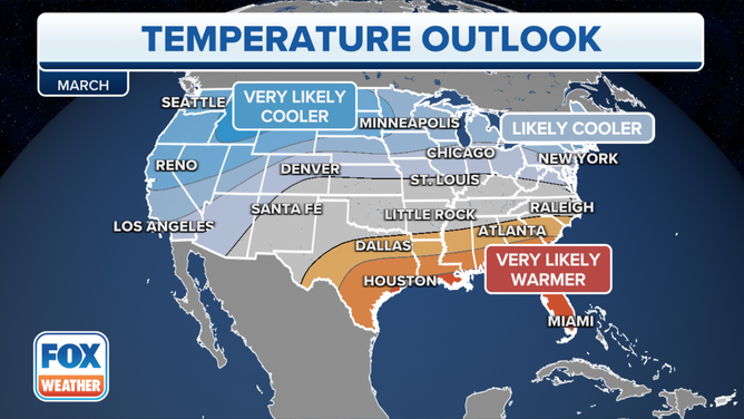
March temperature outlook from NOAA's Climate Prediction Center.
(FOX Weather)