

Multiday washout targets Florida as heavy downpours, thunderstorms linger through weekend
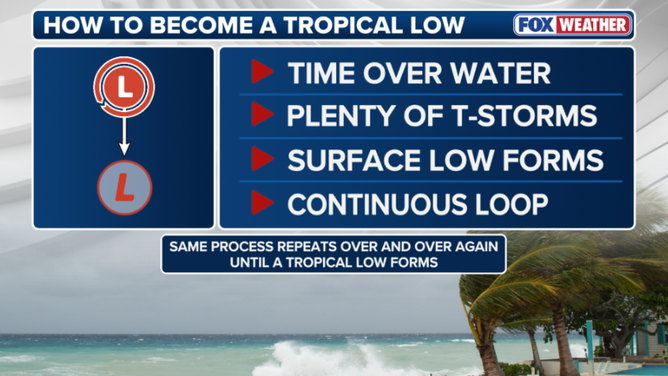
While a stalled cut-off low can occasionally spark heavy storms that lower surface pressure and foster a surface low, a tropical system can only form if the disturbance lingers nearly stationary over warm water for several consecutive days.
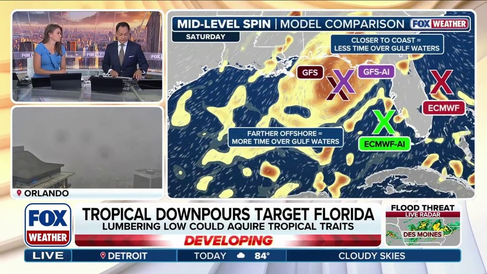
Tropical moisture surges as disturbance takes aim at Florida
Florida’s stormy week is just getting started. Tropical moisture brings daily downpours through mid-week before a mid-level low moves into the Gulf on Thursday, sparking questions about potential tropical development.
THE TAKEAWAY:
- Florida is facing a stormy week as tropical downpours target the region.
- Sea-breeze collisions could bring 1–2+ inches of rain per hour, creating a daily minor flash-flood threat.
- The odds remain low for any tropical disturbance to develop from the nearby low-pressure system.
FLORIDA – Another stormy week has kicked off across the Sunshine State as tropical moisture surges across the region.
This follows a soggy weekend that triggered numerous flood alerts, including in areas that had been unusually dry.
Tropical downpours will drench portions of Florida all week long, through Wednesday, as a massive high pressure heat dome anchored over the eastern U.S. fuels gusty winds and thunderstorms.
WHAT IS A HEAT DOME AND HOW CAN IT AFFECT YOU DURING THE SUMMER MONTHS?
The FOX Forecast Center expects repeated rounds of slow-moving rain showers and thunderstorms, producing precipitation totals of over 1 to 2 inches per hour and fueling a daily flood threat.
By Thursday, the storm pattern will intensify as a mid-level low pressure system is forecast to move out of the Atlantic, across the Florida peninsula and into the Gulf of America.
While this could have brought the possible chance for potential tropical development, odds now remain low.
(FOX Weather)
"As the low tracks across Florida from Thursday into Friday, it is expected to become cut off," the FOX Forecast Center said. "Crucially, this disturbance originates as a cold-core low rather than a warm-core system, which is a distinction that matters for any potential tropical development."
Only a warm-core low can tap into the warm surface waters of the Gulf as fuel. In contrast, a cold-core low relies on steep temperature gradients high above the surface to sustain its strength and rotation.
The FOX Forecast Center said that when a cutoff low gets stuck over the Gulf for a few days, it can trigger widespread showers and thunderstorms.

Cars drive through floodwater after Miami deluge
Heavy rain flooded streets in South Beach, Miami, on Wednesday. The footage shows cars driving through floodwater in South Beach near the MacArthur Causeway.
This system begins as a cold-core low, meaning its spin is sustained by temperature contrasts aloft—such as warm air from a northern heat dome colliding with cooler air within the low—rather than relying directly on warm Gulf waters like a warm-core system.
While a stalled cut-off low can occasionally spark heavy storms that lower surface pressure and foster a surface low, a tropical system can only form if the disturbance lingers nearly stationary over warm water for several consecutive days.
(FOX Weather)
As of Tuesday, computer models are showing a shift, with guidance now indicating the system will stall near Florida or barely graze the northeastern Gulf instead of moving deep into the basin.
Because it will not dwell over open water long enough to complete a structural transformation, the chance for tropical development has dropped to essentially zero.
FLORIDA COUPLE INJURED AFTER BEING STRUCK BY LIGHTNING WHILE OUT ON A WALK
In addition, the FOX Forecast Center notes that when it comes to a low-pressure system of this nature, you can get some different impacts than if it was an area of low pressure closer to the surface.
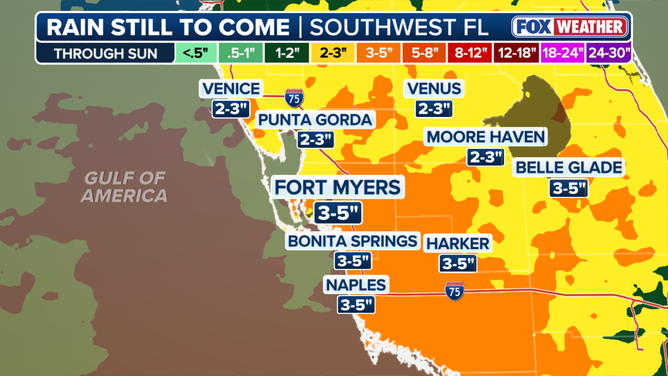
This graphic shows rain still to come in Southwest Florida through Sunday.
(FOX Weather)
Cold air aloft interacting with warm surface conditions could create steep lapse rates, fueling potentially strong storms.
However, dry air wrapping into the system may limit overall storm coverage at times. Frequent lightning, gusty winds, and reduced visibility remain the primary hazards.
HOW HIGH PRESSURE AND LOW PRESSURE DRIVE THE WEATHER
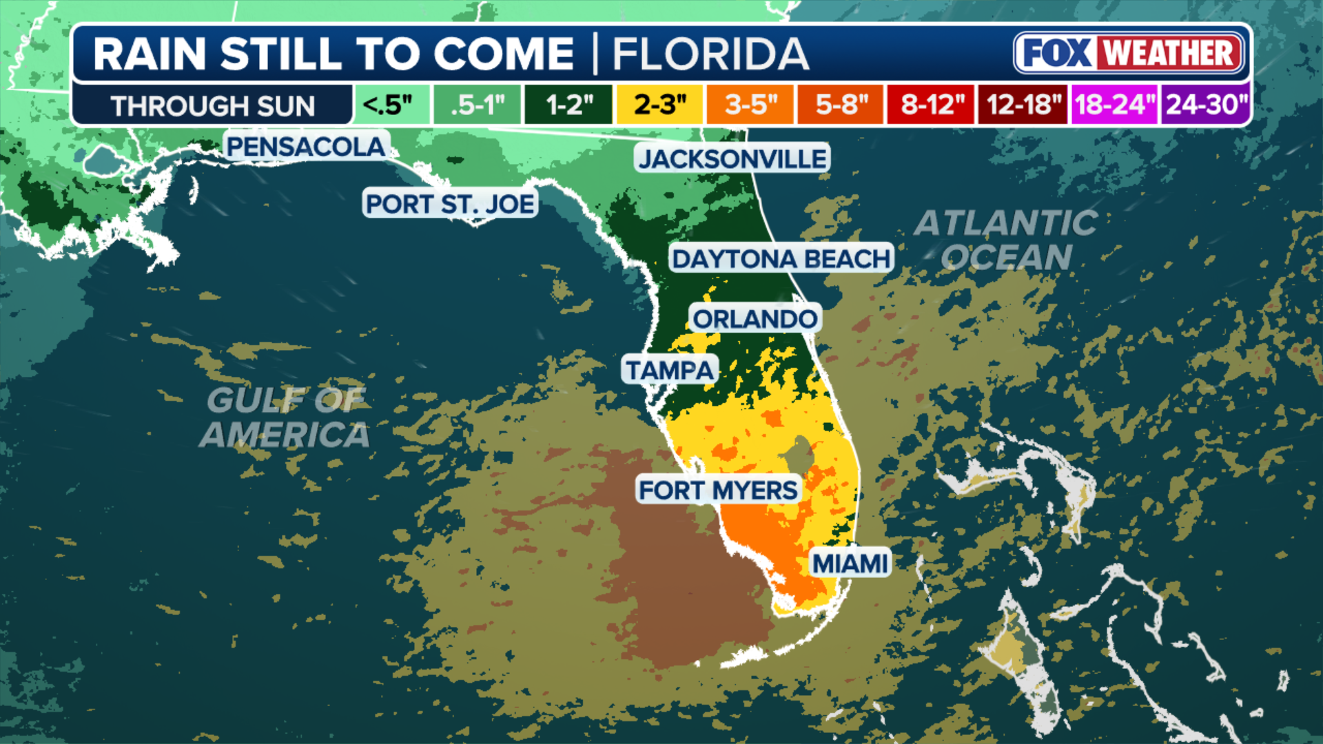
Rain chances stay elevated through the weekend as the low shifts into the Gulf and winds turn southerly, focusing the highest totals over interior areas and the Gulf Coast.
Many spots will pick up 3 to 5 inches of rain by week's end, with some of the highest totals expected around Naples and potentially Miami.
Stay with FOX Weather for the latest forecast.