Severe storms could spawn damaging winds, flooding in Southeast on Monday
The greatest risk for severe weather on Monday will be in northern Florida into portions of Alabama, Georgia and South Carolina.
Severe weather could spawn tornadoes, flash flooding across South
The severe weather threat spans from Florida Panhandle into the Carolinas through Monday night. Flash Flood Warnings are in effect for parts of Georgia on Monday as heavy rain moves through the region.
ATLANTA – Severe thunderstorms are expected across the Southeast on Monday, bringing threats of damaging winds, a few tornadoes and flash flooding.
Monday's severe weather threat is happening on the warm side of the storm system that will eventually become a nor'easter as it blasts the Northeast and New England with heavy snow Monday night and Tuesday.
On Sunday, this system spawned more than 50 reports of severe weather from Texas to western Georgia. That included giant hail as large as 3 inches in diameter just outside of Shreveport in Louisiana. Cars were also damaged by baseball-sized hail in East Texas, according to the National Weather Service.

(FOX Weather)
The soggy start to the workweek was causing delays for commuters in Atlanta, where water rescues were reported as storms prompted flooding, especially on the south side of the metro area.
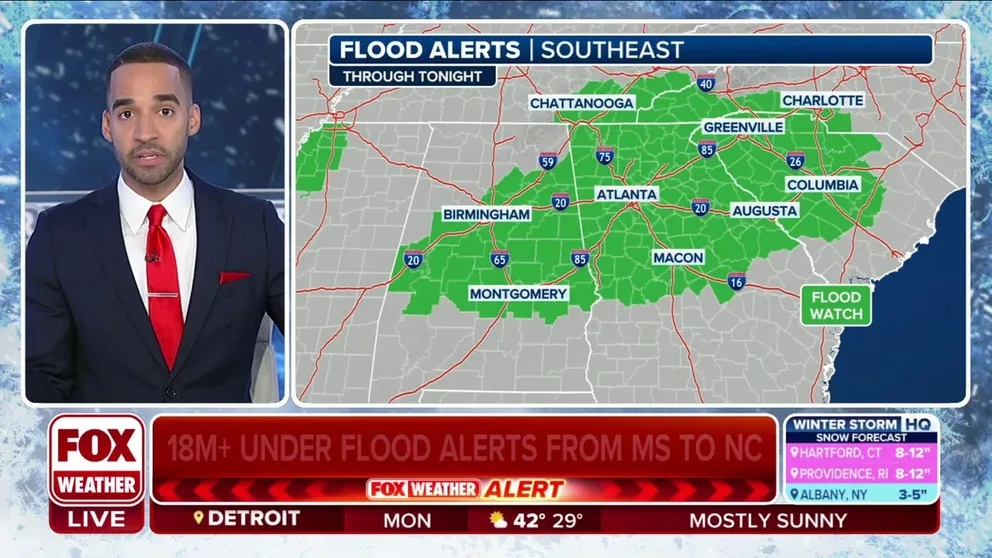
A Flood Watch is in effect for parts of Alabama, including Birmingham and Montgomery, and northern Georgia, including Atlanta, into southeastern Tennessee and parts of the Carolinas.

(FOX Weather)
With heavy rain expected to continue in this region, the Flood Watch is in effect through Monday night.
NOAA's Storm Prediction Center issued a Level 2 out of 5 risk for severe thunderstorms on Monday from northern Florida into portions of Alabama, Georgia and South Carolina.
Damaging wind gusts and a few tornadoes are possible as the storms fire up throughout the day. The greatest risk for severe weather is highlighted in red on the map below.
"We continue with the severe weather threat as this boundary continues to work off to the east," FOX Weather Meteorologist Stephen Morgan said. "Out ahead of it, we still have a supportive environment for severe weather."
A Tornado Watch issued by NOAA's SPC for portions of the eastern Florida Panhandle and southwestern Georgia expired around 3 p.m. EST.

(FOX Weather)
Meanwhile, the threat of flash flooding is highest across parts of Alabama, Georgia and the Carolinas, the FOX Forecast Center said.
FLOOD WATCH, WARNING AND EMERGENCY: HERE ARE THE DIFFERENCES THAT COULD SAVE YOUR LIFE

(FOX Weather)
Between 3 and 5 inches of rain is forecast for the Atlanta metro area through Monday.
The rain and potentially severe storms could cause delays for travelers to and from Atlanta Hartsfield-Jackson International Airport. According to FlightAware, the Atlanta airport was at the top of its MiseryMap on Monday morning with the most delays out of U.S. airports.
"As these storms work off to the east, we're still going to see them moving at a snail's pace. That's going to make those flooding problems and concerns even worse," Morgan said. "As this storm begins to transfer some of its energy into the Atlantic, we'll see that solid shield of moisture through parts of the Carolinas. But on the backside, I don't know how far south that snow might come. Maybe northern Mississippi, parts of Middle Tennessee, a few flakes."

(FOX Weather)
The region will dry out starting Tuesday for a few days before rain likely returns for the third straight weekend.
After the rain pounds the Southeast, the system will move north, eventually becoming a nor'easter. The FOX Forecast Center is forecasting heavy snow for the Northeast, including New York City and Boston.
Severe storms rumbled across the South over the weekend
This potent system worked across the South on Sunday, prompting rounds of Tornado Warnings across Texas and Louisiana, bringing repeated downpours, severe thunderstorms and the potential for flash flooding.
Storms fired off early Sunday across parts of Texas, bringing hail and strong wind gusts.
The National Weather Service office in San Angelo, Texas, reported winds of more than 50 mph early Sunday with half-inch-diameter hail.
![Pea size hail in College Station, Texas on Feb. 11, 2024.]() Image 1 of 2
Image 1 of 2Pea size hail in College Station, Texas on Feb. 11, 2024. (Image: @loganen3/X) ( )
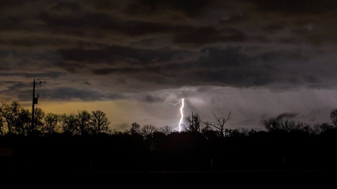
![Lightning seen looking toward Andice, Texas from Liberty Hill on Feb. 11, 2024 during a thunderstorm]() Image 2 of 2
Image 2 of 2Lightning seen looking toward Andice, Texas from Liberty Hill on Feb. 11, 2024 during a thunderstorm. (image: @philostrophy/X) ( )