Why we're watching the northern Gulf of Mexico for tropical development later this week
There’s a lot of energy in the warm Gulf waters, so something could spin up quickly if the ingredients come together
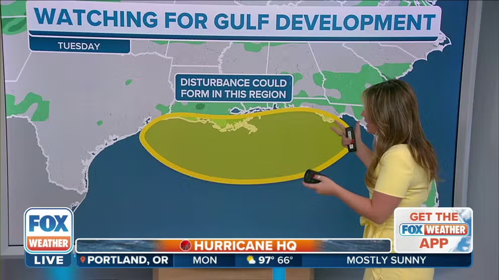
Tropical depression could form in the Gulf of Mexico later this week
This area of tropical moisture, in combination with an upper-level disturbance over Florida, could fuse together and form a tropical depression sometime later this week.
Update as of 9:00 a.m. Monday Eastern time
Two weather features will meet in the northern Gulf of Mexico in the next few days. The combination could trigger a tropical system to quickly spin up over the extra-warm Gulf water.
The water temperature is running several degrees above average – in the high 80s – due to the recent extremely hot weather across the South.
HOW TO WATCH FOX WEATHER ON TV

(FOX Weather)
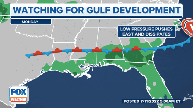
An old cold front has died out along the northern Gulf Coast. Fronts are long areas of lower pressure, and that low pressure can be one factor in the formation of an organized tropical system – if other ingredients are in place.
Over the southern Gulf between Cuba and Mexico, there’s a large, prominent upper-level disturbance. It is drifting toward that old frontal zone in the northern Gulf. The combination of these two systems in the next couple of days might lead to a new system trying to organize.
The National Hurricane Center is giving it a fairly low chance of happening at this point. The two systems are still well separated, so the process of development, if it’s going to happen, has not begun.
Since the front is so close to land, it’s impossible to know if an organized system would form over the water, where it conceivably could gain a circulation and strengthen. Or it might develop over land, where it would be mostly just a big rainmaker.
DAYS-LONG TORRENTIAL RAIN BRINGS FLOODING CONCERNS TO GULF COAST, SOUTHEAST
(FOX Weather)
There is no consensus in the computer forecast models on exactly what’s going to happen, though there is general agreement that a concentrated area of low pressure will begin to form somewhere between Louisiana and the Florida Panhandle in the next day or two. If it forms over the water, eventually, it would likely drift inland. The question is, does it remain over the water long enough to organize and possibly strengthen?
In any case, significant rainfall is likely along the northern Gulf Coast, though the exact location of the heaviest rain will be dependent on what develops and exactly where.
Be ready for changing forecasts this week from Louisiana to the Florida Panhandle. There’s a lot of energy in the warm Gulf waters, so something could spin up quickly if the ingredients come together.
WHERE TROPICAL STORMS AND HURRICANES TYPICALLY OCCUR DURING EACH MONTH OF ATLANTIC HURRICANE SEASON
Elsewhere in the tropics, there is a lot of dust and dry air, so things are quiet.

(FOX Weather)
Be sure to download the FOX Weather app to stay up-to-date on everything in the tropics this hurricane season. The free FOX Weather livestream is also available 24/7 on the website and app and on your favorite streaming platform. The FOX Weather Update podcast also provides weather information for the entire country.
CLICK HERE TO GET THE FOX WEATHER UPDATE PODCAST
FOX Weather Hurricane Specialist Bryan Norcross also has a podcast, Tracking the Tropics with Bryan Norcross, available now on FOX News Audio. You can download it on your device by clicking here.