Tropical disturbance continues to produce flash flooding as it spins across Southwest Texas
Some parts of Texas have seen 6 to more than 7 inches of rain from the tropical disturbance that's spinning across the Lone Star State.
Tropical moisture brings flash flood threat to Southwest Texas on Tuesday
The final bit of tropical moisture will work it's way into Southwest Texas today before weakening and dissipating by Wednesday morning.
A tropical disturbance that pushed onshore in Texas over the weekend continues to spin across the state, bringing heavy rain and the risk of flooding to the region on Tuesday.
South Texas saw several Flash Flood and Tornado Warnings on Monday as the system drifted toward the northwest.
Now on Tuesday, Flash Flood Warnings have been issued in parts of Southwest Texas.
HOW TO WATCH FOX WEATHER ON TV

(FOX Weather)
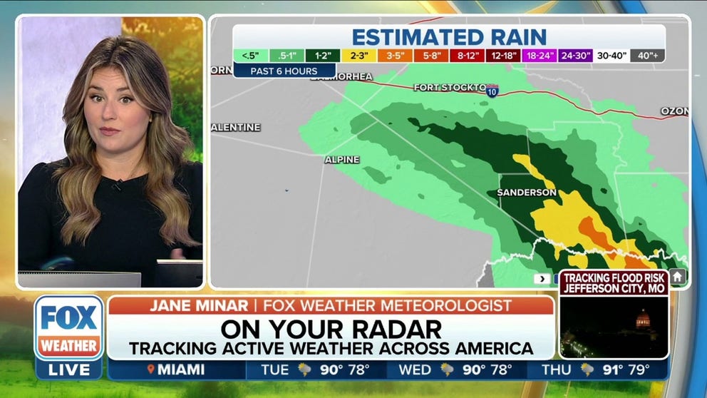
"We've seen significant rain over the last six hours, especially to the south of Sanderson, where we have picked up a swath of anywhere from 2 to 3 up to 5 inches of rain," FOX Weather meteorologist Jane Minar said.
And more heavy rain is expected on Tuesday and Tuesday night.
The highest totals will be found across Southwest Texas, where some areas, like Fort Stockton and Alpine, could see those 3- to 5-inch rain totals.
Farther west, El Paso will likely see an additional 1 to 2 inches before the system moves out of the region by Wednesday.
EXPLAINING FLOOD ALERTS ISSUED BY NATIONAL WEATHER SERVICE

(FOX Weather)
There have also been some impressive rain totals across Texas over the past three days, according to the FOX Forecast Center.
Port O'Connor has seen more than 7 inches of rain so far, while Hebbronville has received just under 7 inches.
Monday was the wettest day in Laredo in almost five years – since Sept. 26, 2017 – with 3.19 inches of rain, crushing the Aug. 15 daily record of 0.91 inches.
Corpus Christi broke a rainfall record on Sunday after receiving more than 2 inches of rain during the day. That broke its old record of 1.09 inches set back in 1998.
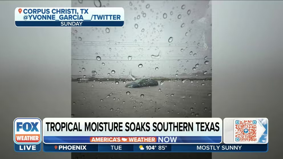
Cars attempt to drive through floodwaters in South Texas
Vehicles submerged in water as tropical moisture soaks Corpus Christi, Texas.
The heavy rain led to flooding across the region, especially in Corpus Christi, where several photos and videos posted to social media showed water covering roads.
It's advised that if you're driving and you see water covering a roadway, it's best to turn around, don't drown.
It doesn't take much water to carry a vehicle away.
7 FACTS YOU SHOULD KNOW ABOUT FLASH FLOODS

(FOX Weather)
The greatest flash flooding risk on Tuesday includes areas of Southwest Texas from around the Van Horn area south through Valentine, Alpine, Presidio and Study Butte.
This is because as the tropical disturbance continues to spin across the area, bands of heavy rain and thunderstorms are likely to fall across the same places over an extended period of time.
Any bands of showers and thunderstorms are likely to produce very heavy rainfall rates, and that could overwhelm drainage systems designed to help remove water on roads and highways.