Atlantic Basin to become more conducive for tropical development heading into August
FOX Weather Hurricane Specialist Bryan Norcross says he sees signs that conditions may become more conducive for tropical development in the Atlantic Ocean as we head into August.

Hurricane analysis: Atlantic tropical wave train is rolling off Africa
FOX Weather Hurricane Specialist Bryan Norcross says dives into the changes we're seeing this week in the Atlantic for tropical development. With August right around the corner, Norcross said it's typical for activity to pick up during hurricane season.
MIAMI – It’s been a relatively quiet start to the 2025 Atlantic hurricane season, but all that could change dramatically as we head into the first part of August as there are signs that conditions are set to become more conducive for tropical development, according to FOX Weather Hurricane Specialist Bryan Norcross.
"We're not trying to pin anything down, just saying it looks like conditions could become more conducive maybe eight, nine, 10 days from now based on a consensus of the various models, but certainly nothing specific," Norcross said on Tuesday.
(FOX Weather)
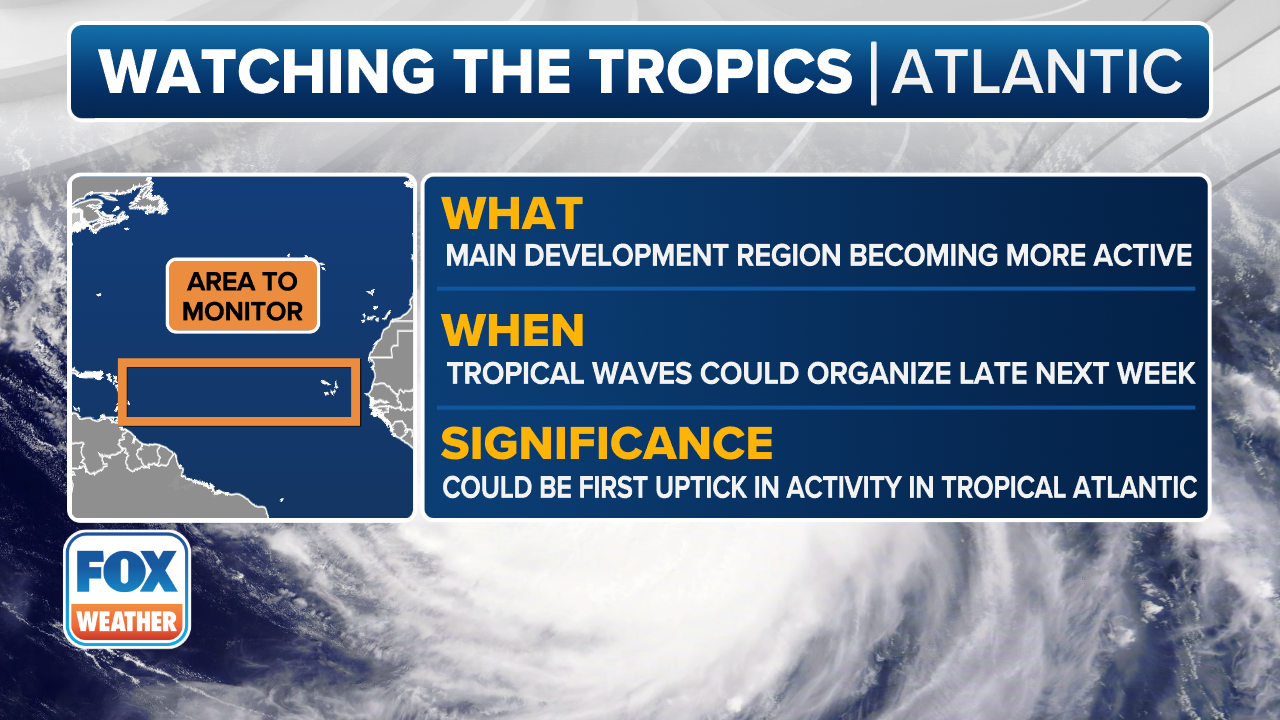
The Atlantic's Main Development Region shows signs of life
While dry, dusty air from the Sahara desert and hostile winds have effectively put a lid on tropical development in the Atlantic Ocean's Main Development Region so far, the atmospheric conditions that have been so supportive of tropical development in the Pacific Ocean Basin are going to shift into the Gulf, Caribbean and Atlantic.
"We're just going to keep an eye as the atmosphere becomes just more ready for storms to develop somewhere in this tropical zone, not too far from the U.S."
That timing lines up with what we can typically expect to see from the Madden-Julian Oscillation (MJO), which is a global weather pattern that can help to boost tropical activity when it moves over a region.
The MJO does look to become more favorable for the Atlantic in early August if it can hold together in the Eastern Pacific.
DOWNLOAD THE FREE FOX WEATHER APP
Meanwhile, the FOX Forecast Center is monitoring two disturbances that have moved off the coast of Africa and into the Atlantic Ocean.
Much of the Atlantic is still blanketed with Saharan dust and dry air, but some computer forecast models are suggesting that this disturbance is carrying enough moisture that it could survive its trek toward the Caribbean.
It won’t be an easy journey, however.
The FOX Forecast Center said dry air and hostile winds high in the atmosphere will likely weaken the system as it moves off to the west, so the most likely outcome is just a wave of moisture reaching the Caribbean later this week.
That being said, the FOX Forecast Center said both traditional computer forecast models and newer, AI-driven models do show the disturbance possibly holding together as a weak tropical disturbance near the northeastern Caribbean by this weekend.
There’s no indication at this point that it will be a strong system, but it’s something worth watching in the coming days.
BRYAN NORCROSS: FIRST SIGNIFICANT AFRICAN DISTURBANCE TO TRACK ACROSS ATLANTIC THIS WEEK

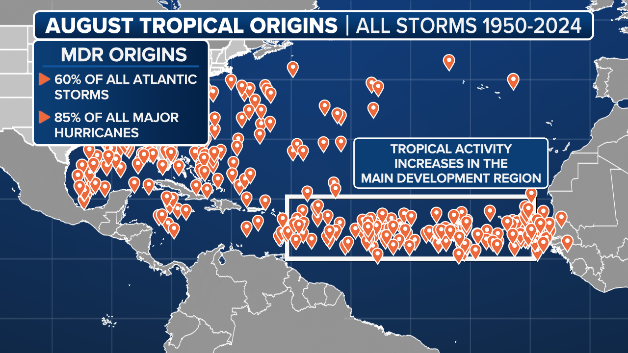
This map shows where tropical cyclone activity tends to occur in August.
(FOX Weather)
But looking ahead, as the atmosphere over the Caribbean and Atlantic becomes more conducive for tropical development, a belt of warm water has emerged across the southern part of the Atlantic's Main Development Region, which would support those tropical disturbances moving off the coast of Africa.
"There is this corridor of very warm water here down to the south. And these storms ... or systems are going to kind of track along that corridor of warm water," Norcross said.
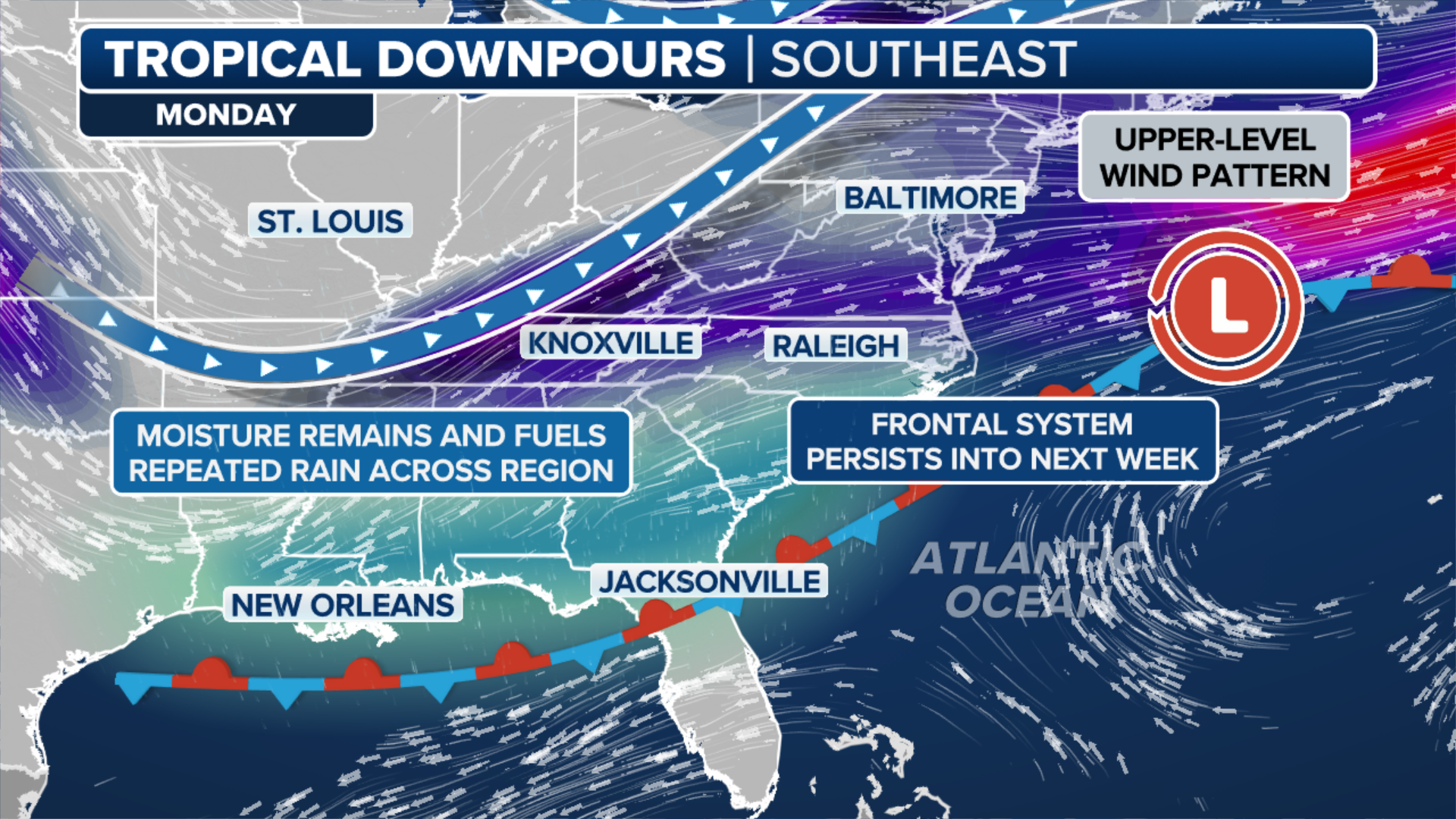
More activity possible along Southeast, Gulf coasts
(FOX Weather)
It’s not only the Atlantic and Caribbean that bears watching.
The FOX Forecast Center is once again monitoring possible tropical trouble near the Southeast coast as a front stalls later this week.
No disturbances are immediate, but heavy rain and thunderstorms across the region could once again bring a flood threat.
The region has been a hotspot lately, and that’s not expected to change anytime soon.
A powerful cold front will move from the northern tier into the Southeast, stalling out well into the Atlantic.
NOAA's Climate Prediction Center (CPC) is highlighting the area as having a low chance of tropical development.
BRYAN NORCROSS TACKLES MORE HURRICANE SEASON QUESTIONS WITH EXPERT INSIGHT
(FOX Weather)
Again, it’s still too early to pinpoint any single disturbance along the cold front, but that setup could bring another round of unsettled weather to the same areas that have already been active over the past few weeks.
If that front stalls in a more favorable atmosphere pocket, there’s an outside chance that a weak tropical system could try and form.
It’s also still unknown if an area of low pressure would form well into the Atlantic or closer to the Southeast coast or the Gulf Coast.
Each area would result in a potentially different scenario.