'Omega block' breaking down to bring hot, rainy weather to much of US
Meteorological summer begins on June 1 and will end on the last day in August. The greatest temperature anomalies will exist over the Mississippi and Ohio valleys, where highs could reach at least 10 degrees above average.
Pattern change to bring rain, spring temperatures next week
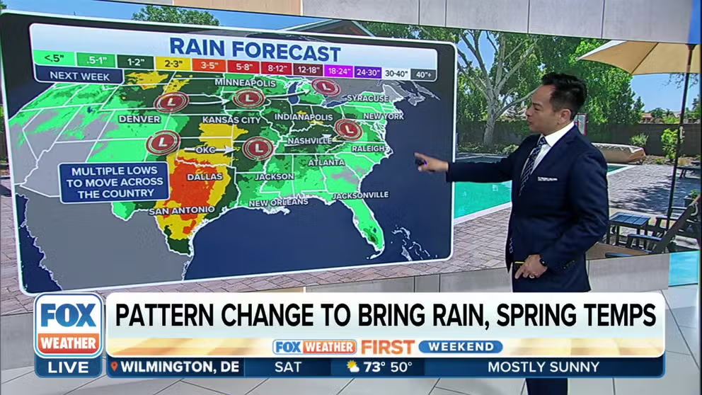
Rain is expected to develop next week across the majority of the Central and Eastern U.S., bringing along summerlike temperatures and moisture.
The FOX Forecast Center is tracking changes in the nation’s weather that could result in a summerlike pattern across much of the country.
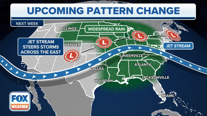
Since late April, the majority of the lower 48 have been dominated by an Omega block, which resulted in stormy weather along the coasts and drier weather across the heartland. A more zonal flow will increase the chances of rain and allow for warmer temperatures.

FILE - A woman holds an umbrella.
(David Paul Morris/Bloomberg via Getty Images / Getty Images)
"We’ll start to bring in those rain chances into portions of the Southeast and into all the way the upper Midwest and the Great Lakes region as well. Now, temperature-wise, we’ll still be on the warmer side of things, rather, so about 10 to 20 degrees above average," said FOX Weather meteorologist Kendall Smith.
The projected weather appears to be a bit of change than what NOAA expected to see during the last month of climatological spring, but forecasters caution the month is still young, and there are questions about how long the new pattern will stick around.
U.S. Pattern Change Setup Forecast
(FOX Weather)
Rainfall outlook
Forecast models show several areas of low pressure will traverse across the country over the next week, leading to decent chances of precipitation from Texas into the central Plains and into the Mississippi and Ohio valleys.
This could lead to 3-5" of rain for some communities in the Lone Star State, with many parts of the Plains seeing between 1-3".
The precipitation will be welcome news, where nearly every county in the Plains is dealing with drought conditions. Nearly 40 percent of Kansas is in what the U.S. Drought Monitor identifies as an exceptional drought. The severity of the drought can lead to widespread crop and pasture losses as well as shortages of water.

"It’s definitely going to help out with those drought-stricken areas, especially like in western Kansas and into the panhandles of Oklahoma and Texas," said Smith.
Some areas, however, may experience flash flooding due to the heavy rain.
The storm systems will largely lose their moisture content east of the Appalachians, which means expected rainfall values will be greatly reduced compared to the central Plains.
The FOX Forecast Center said the pattern does not typically support widespread severe weather outbreaks, but some storms will occasionally produce hail and damaging winds, if local atmospheric conditions are conducive.

Temperature outlook
Unlike an organized cold front that typically brings in a rush of cooler, drier air, these storm systems are not expected to lead to a drop in temperatures.
Throughout the next week, areas of the Plains, Mississippi and Ohio valleys will be the target of warm air, allowing temperatures to rise at least 10 degrees above normal.
Oklahoma City could see several days of temperatures in the 80s and even 90s, while climatologically, they should only be in the 70s.

Cities such as St. Louis, Missouri, and Des Moines, Iowa, are in much the same scenario, with daily high temperatures expected to feel more like summer.
The summerlike temperatures will also be seen farther north.
"The Pac Northwest will be warming up for the middle part of next week," said FOX Weather meteorologist Britta Merwin. "That's great news for cities like Portland. It has been gray, you're heading into your Rose Festival, so it's nice to have some warmer weather for you."
The warm and stormy pattern for millions could break down as early as next weekend, but forecasters say it is still too early to determine if and when any colder and drier air will return.