Tropical Storm Jerry soaks Leeward Islands with several inches of rain as Karen forms in North Atlantic
All former Tropical Storm Warnings have been discontinued. But even in its weaker state, Jerry is still drenching some of the Leeward Islands with several inches of rain, triggering flash flooding dangers.
Tropical Storm Jerry soaks Leeward Islands with 2-6 inches of rain
Tropical Storm Jerry was lashing some of the northern Leeward Islands Friday bringing heavy rains and flash flooding threats.
MIAMI – Tropical Storm Jerry continues to lash the northern Leeward Islands with heavy rains on Friday morning, but it's slowly pulling away, with decreasing impacts expected as the day progresses.
All former Tropical Storm Warnings have been discontinued. But even in its weaker state, Jerry is still drenching some of the Leeward Islands with several inches of rain, triggering flash flooding dangers.
DOWNLOAD THE FREE FOX WEATHER APP

(FOX Weather)
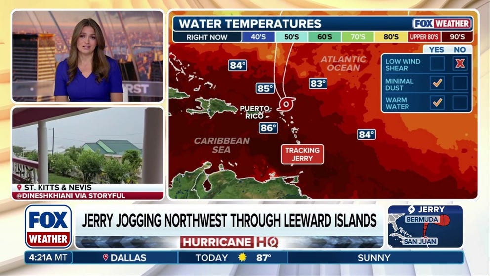
As of the latest advisory from the NHC, Tropical Storm Jerry's maximum sustained winds have dropped to 50 mph with some higher gusts. The storm is located about 140 miles to the north of the northern Leeward Islands and is moving off to the northwest at 16 mph.
The National Hurricane Center (NHC) says Jerry is still fighting moderate to strong wind shear, preventing it from gaining any further traction. In fact, the NHC has pulled back on Jerry's future prospects, no longer predicting the storm will reach hurricane strength.
Heavy rains soaking the Leeward Islands
Through Friday, about 2-4 inches of rain with some locally higher amounts of up to 6 inches is expected across the Leeward Islands and the British and U.S. Virgin Islands.
That rainfall brings the risk of flash flooding, especially in areas of higher terrain.
In parts of Puerto Rico, moisture associated with Jerry, combined with local orographic effects, may result in up to 2-4 inches of rain, with some locally higher amounts of up to 6 inches possible.
In addition, swells generated by Tropical Storm Jerry are spreading westward toward the Greater Antilles on Friday and into the weekend. Those swells are likely to cause large waves and life-threatening rip currents at local beaches.
(FOX Weather)
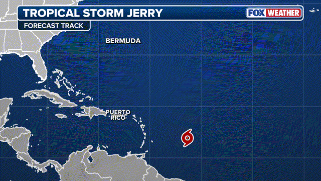
Jerry is forecast to continue to pull away to the north of the Leeward Islands Friday, and continue north through the weekend in open waters as a moderate to strong tropical storm. The storm will then take a sharp turn to the east on Monday and continue its journey away from North America through early next week.
Subtropical Storm Karen formes in North Atlantic

(FOX Weather)
Just to keep the tropics map busy, another storm percolating in the far North Atlantic suddenly gained some tropical characteristics late Thursday and became named Subtropical Storm Karen overnight.
A subtropical storm has characteristics of both tropical and extratropical cyclones. Most of its energy is derived from the clash of warm and cold air, but the cyclone does not have fronts and is cold-core in the upper levels of the atmosphere.
WHAT'S THE DIFFERENCE BETWEEN A TROPICAL STORM AND A SUBTROPICAL STORM?
Karen was found to have both traits and was estimated to have winds of 45 mph, meeting the criteria to earn a name from the NHC.
However, Karen will mainly be just a footnote in the tropical season, as it is expected to lose its tropical features on Saturday and become absorbed into another passing storm over the weekend.