Tropical Depression Nine expected to become Tropical Storm Harold before Texas landfall
A Tropical Storm Warning has been issued for the mouth of the Rio Grande to Port O'Connor, Texas. A Tropical Storm Watch is in effect for Port O'Connor to Sargent, Texas.
Tropical Depression Nine threatening to become Tropical Storm Harold and making landfall in Texas
FOX Weather is tracking Tropical Depression Nine which is forecast to strengthen into Tropical Storm Harold and making landfall in Texas.
As of Tuesday at 2:00 A.M, the National Hurricane Center noted in their latest advisory that Tropical Depression Nine has strengthened into Tropical Storm Harold. Continuous coverage of Harold has moved here.
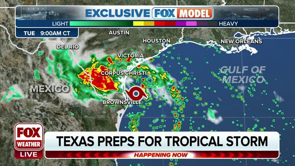
Tropical Depression Nine is strengthening in the central Gulf of Mexico and is on track to eventually become Tropical Storm Harold as it eyes a South Texas landfall Tuesday, bringing the potential for heavy rain, gusty winds, and some coastal flooding.
A tropical depression has maximum sustained winds of 38 mph or less, and unlike tropical storms and hurricanes, tropical depressions are identified with numbers and not names.
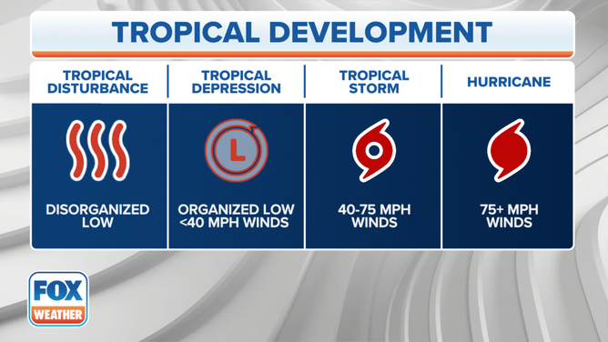
The stages of tropical development.
(FOX Weather)
Where is Tropical Depression Nine?
Tropical Depression Nine is in the central Gulf of Mexico about 260 miles east-southeast of Port Mansfield, Texas, and is expected to approach the western Gulf of Mexico coastline by Tuesday as it charges west at about 18 mph. Maximum sustained winds are 35 mph.
GUIDE FOR 2023 ATLANTIC HURRICANE SEASON

(FOX Weather)
What is the forecast track for Tropical Depression Nine?
Satellite images indicate that the system is becoming better organized, and the NHC says Nine is expected to eventually become Tropical Storm Harold overnight.
The current forecast track has the storm continuing west, making landfall on the South Texas coast Tuesday morning or midday.

(FOX Weather)
HERE ARE THE HURRICANE NAMES FOR THE 2023 ATLANTIC SEASON
What watches and warnings are in effect for Tropical Depression Nine?
A Tropical Storm Warning has been issued for the mouth of the Rio Grande to Port O'Connor, Texas. A Tropical Storm Watch is in effect for Port O'Connor to Sargent, Texas.
A Tropical Storm Warning means that tropical storm conditions are expected somewhere within the warning area, in this case within 24 hours. A Tropical Storm Watch means that tropical storm conditions are possible within the watch area, in this case within 24 hours.
"Tropical Storm-force winds and heavy rains expected to begin overnight," wrote the NHC warning South Texas.

(FOX Weather)
What are the expected impacts of Tropical Depression Nine?
The system, regardless of strength, is expected to bring much-needed rain to the South Texas area Tuesday and Wednesday, the FOX Forecast Center said. Tree to five inches of rain is forecast for South Texas, but some locations may pick up as much as 7 inches of rain through Wednesday morning.
The heavy rainfall may produce areas of flash and urban flooding.

(FOX Weather)
With generally dry ground thanks to rapidly developing drought conditions, flash flooding will be a concern for places like Corpus Christi, Laredo, and Brownsville on Tuesday.
A couple of tornadoes are also possible early Tuesday into the afternoon.

(FOX Weather)
In addition, some coastal flooding is possible along the south Texas coast Monday night through Tuesday morning with a minor storm surge. The deepest surge will occur along the coast near and to the north of the storm's eventual landfall, according to the NHC, with potential of 1-3 feet of water rise from the Rio Grande to Sargent, including Baffin Bay, Corpus Christi Bay and Matagorda Bay.
"Surge-related flooding depends on the relative timing of the surge and the tidal cycle, and can vary greatly over short distances," the NHC said.
Rain will taper off later Wednesday with dry weather returning for the rest of the week.