Developing nor'easter triggers high wind alerts, flood watches for millions along the East Coast
A brewing nor'easter is expected to slam the Atlantic Seaboard over multiple days with heavy rains, 'major' coastal flooding and potentially damaging wind gusts.

Bryan Norcross: Nor'easter set to pummel from Carolinas to New England
Several impacts from coastal flooding to damaging wind gusts to heavy rains are likely up and down the Eastern Seaboard as a powerful Nor'easter takes shape.
NEW YORK – A brewing nor'easter is expected to slam the Atlantic Seaboard over multiple days with heavy rains, 'major' coastal flooding and potentially damaging wind gusts, prompting one state to already preemptively declare a state of emergency.
Over its multiple-day journey up the coast, the storm is set to thrash the coastal Carolinas on Saturday, then spread its impacts into the Northeast on Sunday. Forecasters in New Jersey are warning of possible major coastal flooding over the latter half of the weekend in the southern half of the state, with even the potential need for some evacuations.
Acting New Jersey Governor Tahesha Way says all 21 counties in New Jersey are in a statewide emergency starting midday Saturday due to the storm's threat. The declaration will help speed up emergency services and free up more resources for storm preparations and response.

Meanwhile, the wind threat has already triggered High Wind Watches across parts of the nation's most populous corridor, with forecasters saying gusts up to 60 mph could impact close to 10 million Americans along the New Jersey Coast on Sunday and in New York's Brooklyn, Queens and Long Island by Sunday night. It'll then be New England's turn to weather the storm early next week.
"As this coastal storm approaches, I’m urging all New Yorkers to stay alert, watch the forecast closely, and take steps now to prepare," New York Governor Kathy Hochul announced. "Conditions can change quickly, so please use caution if you need to travel and check on friends and neighbors who may need extra help. Staying vigilant and informed will help keep everyone safe through the weekend."
According to the FOX Forecast Center, some areas along the East Coast may see major coastal flooding rivaling high water marks set by Superstorm Sandy or approach all-time records.
Carolinas feel Nor'easter's impacts starting Saturday
Into the morning on Saturday, our Nor'easter will begin to take shape, impacting portions of the Carolinas and the Outer Banks.
Heavy rain will begin impacting the coastlines in the morning through late evening with widespread totals of 2-3 inches, with locally higher amounts across the Outer Banks of 3-5 inches or more, according to the FOX Forecast Center.

Southeast rain forecast through Sunday.
A Level 2/4 flash flood risk is in place from Wilmington, North Carolina, through Norfolk, Virginia on Saturday.
Meanwhile, winds will increase into the afternoon with gusts around 40–50 mph along the coastline.
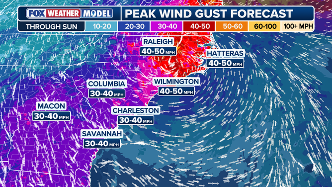
Southeast Guts Forecast
With persistent onshore winds, coastal flooding and high surf will remain a concern for already vulnerable coastlines. Coastal Flood Advisories are in place across North Carolina, while Coastal Flood Warnings remain in place along the Atlantic coast of Florida.
High winds, coastal flooding slam mid-Atlantic on Sunday
By Sunday morning, the center of our Nor'easter will be somewhere close to coastal Virginia. Rain will begin to move into Maryland through southern Long Island by early morning, the FOX Forecast Center said. Downpours will continue through the afternoon as winds also increase.
High Wind Watches are in place from Long Island through coastal New Jersey and Delaware. This calls for wind gusts upwards of 60 mph and sustained winds around 25-35 mph along the coast. Already, New York has suspended Fire Island ferry service for Sunday and Monday.

(FOX Weather)
But as winds remain out of the northeast and wave heights build, coastal flooding will also be a concern from Virginia through New England.
While over 25 million are under Coastal Flood Alerts along a 400-mile stretch from Atlantic City, New Jersey, through Boston and remain in effect through Monday, concern is growing for major impacts along the New Jersey and Delaware coast.
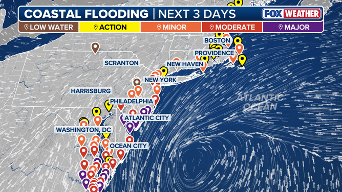
Northeast Coastal Flooding
(FOX Weather)
"Moderate to Major coastal flood impacts are increasingly likely," National Weather Service forecasters in Mount Holly, New Jersey wrote Friday morning. "Widespread roadway flooding and impassable roads, inundation of structures, and evacuations are possible Sunday-Monday. Significant beach erosion and dune breaching is possible due to very high surf. Now is the time to prepare your property for the threat of coastal flooding."

Northeast Rainfall Forecast
Heavy rain will also increase the risk of flash flooding. A widespread 3-5 inches of rain is possible along the coast through Tuesday.

(FOX Weather)
A large Level 2/4 flash flood risk is present from Ocean City, Maryland, through the Jersey coast, Long Island and southern New England for Sunday.
"There's going to be huge disruptions if this forecast works out anything like this. Huge disruptions to everything in the Tri-State area here," said FOX Weather Hurricane Specialist Bryan Norcross. "All three (New York area) airports, Boston-Logan; it's just going to be a mess because these winds coming in with this velocity at this angle, it's just going to be very difficult to operate anything up there."
And Norcross noted the winds would be piling water up at the coast.
"(It will be) pushing water into New York Harbor, pushing water into Barnegat Bay and the other bays and rivers and inlets that are along the Jersey shore, not to mention up here in New England. And then on Tuesday, it weakens and kind of moves away."

Ahead of the anticipated arrival of the nor'easter, the boardwalk in Rehoboth Beach, DE was still crowded on Friday afternoon.
(Courtesy of Mike Seidel / FOX Weather)
Rain slowly dissipates Monday, but soggy conditions remain
Into Monday morning, heavy rain and gusty winds will slowly begin to dissipate as the system moves onshore over New Jersey and Pennsylvania and weakens. But soggy conditions and breezy winds will likely last through the afternoon, along with coastal flooding concerns as winds remain onshore for another day, The FOX Forecast Center said.